
Deep River (Indiana) facts for kids
Quick facts for kids Deep River |
|
|---|---|

Lake George, a 275 acre man-made lake on Deep River, in Hobart, Indiana.
|
|
| Country | United States |
| State | Indiana |
| Cities | Crown Point, Hobart, Lake Station |
| Physical characteristics | |
| Main source | Indiana 675 ft (206 m) 41°25′25″N 087°19′09″W / 41.42361°N 87.31917°W |
| River mouth | Confluence of Deep River with Little Calumet River Lake County, Indiana 591 ft (180 m) 41°34′16″N 087°17′32″W / 41.57111°N 87.29222°W |
| Basin features | |
| Tributaries |
|
The Deep River is a river in northern Indiana, United States. It flows for about 29.5 miles (47.5 kilometers) towards the northeast. This river joins the Little Calumet River in Lake County. Deep River is part of a larger water system. This system helps drain about 10% of northern Indiana. Eventually, its waters reach Lake Michigan at the Port of Indiana-Burns Harbor.
Contents
Deep River's Story: A Look Back in Time
The Deep River area has a long history. In the summer of 1834, William Ross became the first settler in Lake County. He built his home near where Turkey Creek meets Deep River.
Just two years later, in 1836, land was bought from the Potawatomi people. This land was where Deep River meets the Little Calumet River. A town called Liverpool was planned there. Later, George Earle bought Liverpool. He then moved about two miles southeast and planned the town of Hobart in 1848. Liverpool was briefly the county seat, but Crown Point soon took its place.
The Historic Wood's Mill
In 1835, a man named John Wood started a mill project. By 1837, he had built both a saw-mill and a grist mill. A grist mill grinds grain into flour. This place was first called Woodvale. Today, it is known as Deep River, Indiana. It is also the site of the Deep River County Park. The original grist mill has been rebuilt there. A local vintage baseball team even calls themselves "the Grinders" after the mill!
Where Deep River Flows: Understanding its Watershed
A watershed is an area of land where all the water drains into a single river or lake. The Deep River starts near Interstate 65 on the east side of Crown Point. It begins where two ditches, Main Beaver Dam Ditch and Smith Ditch, meet.
The river then flows east and northeast. It reaches a man-made lake called Lake George in Hobart. This lake was created by a dam built in 1840 by George Earle. Lake George is about 3 miles (5 kilometers) long and 980 feet (300 meters) wide.
From Lake George, Deep River winds its way north and northeast. It then joins the Little Calumet River (LCR) in Lake Station. The LCR then flows east through a man-made channel called "Burns Ditch." This channel connects to the East Arm Little Calumet River. Finally, the water flows north into Lake Michigan through the Port of Indiana-Burns Harbor in Portage, Indiana.
Deep River's Tributaries
Tributaries are smaller streams or rivers that flow into a larger one. Deep River has three main tributaries:
- Turkey Creek
- Deer Creek
- Duck Creek
Nature Along Deep River: Its Ecology
More than 10% of the land around Deep River is covered by wetlands. Wetlands are important areas where land and water meet. They help filter water and provide homes for many plants and animals.
The "Save the Dunes" group has received money to help nature around Deep River. They are working to change 18 acres of farmland back into marshland in Hobart Marsh. This marsh is next to Lake George and Deep River. Once finished, this land will become part of the Indiana Dunes National Park.
Trees and Fish
The trees along Deep River are typical for wet, low-lying areas. You can find elm, ash, and maple trees. Other common trees include sycamore, box elder, river birch, and willow.
The Burns Waterway, which connects to Deep River, is known for its fish. It is a special stream for salmon and trout. These fish are known to swim up Deep River as far as the Lake George dam.
Fun on Deep River: Recreation
Deep River is generally slow-moving. Its speed is usually less than one mile per hour. Some parts of the river have many log jams, which can make it hard to travel by boat.
The best time for canoeing on Deep River is in the spring. During the summer, the water levels can get too low for canoeing.
Images for kids
-
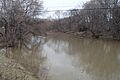
Deep river between Hobart and Lake Station
-
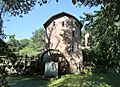
Wood's Grist Mill Built in 1837-1838 by John Wood, re-built in 1876 and recently restored by Lake County Parks. It was the first industry in the county.


