
Trail Creek (Lake Michigan) facts for kids
Quick facts for kids Trail Creek |
|
|---|---|

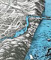
Bird's Eye View of Michigan City, 1869, by A. Ruger (partial sketch).
|
|
| Native name | Myewes-zibiwe |
| Other name(s) | La Rivière du Chemin (River of the Trail) |
| Country | United States |
| State | Indiana |
| Region | LaPorte County |
| City | Michigan City, Indiana |
| Physical characteristics | |
| River mouth | Lake Michigan Michigan City, Indiana 581 ft (177 m) 41°43′27″N 086°54′32″W / 41.72417°N 86.90889°W |
| Basin features | |
| Tributaries |
|
Trail Creek is a stream in Indiana, about 7.3 miles (11.7 km) long. It flows north and northwest. The main part of the creek starts where the West Branch Trail Creek and East Branch Trail Creek meet in LaPorte County, Indiana. Trail Creek flows into Lake Michigan, forming a harbor and marina next to Washington Park in Michigan City, Indiana.
Contents
History of Trail Creek

The Potawatomi people called this creek Myewes-zibiwe. This name means "trail-creek." It referred to the "Potawotami Trail," which was a path that went from Chicago along the south shore of Lake Michigan. The trail followed Trail Creek, then went to Hudson Lake, and finally to the French Fort St. Joseph in what is now Niles, Michigan.
The French named the creek La Rivière du Chemin, which also means "River of the Trail." Later, in 1815 and 1818, people called it the Road River or Chemin River.
In 1816, a survey showed that Trail Creek was about 30 feet (9.1 m) wide. Near its mouth, on the west side of the harbor, there was a huge sand dune called "Hoosier Slide." This dune was about 200 feet (61 m) tall. For comparison, today's Mount Baldy in Indiana Dunes National Park is only 120 feet (37 m) tall.
The top of Hoosier Slide was covered with trees. People from Chicago would visit for picnics and weddings. They enjoyed beautiful views of the lake and the large lumberyards in Washington Park. From 1890 to 1920, Hoosier Slide was removed by mining its sand. This sand was used to make glass and to fill land in Chicago's Jackson Park. It was also used for the Illinois Central Railroad tracks. The area where Hoosier Slide once stood was later used to build a power plant in the late 1920s.
In 1832, a man named Isaac Elston bought 160 acres (65 ha) of land, including Trail Creek and its harbor. He wanted to build a road for settlers in central Indiana. This road would help them send their farm crops to Lake Michigan for trade. Michigan City grew because of Elston's plan.
Early visitors loved the area's wild beauty, its many wildflowers and berries, and especially the amazing Hoosier Slide and other sand dunes. Michigan City became an official town in 1836. Its early success came from the flowing water of Trail Creek. This water was perfect for building lumber and gristmills. In the 1800s, 13 gristmills were built along the banks of Trail Creek.
Trail Creek's Watershed and Path


A watershed is an area of land where all the water drains into a single river, lake, or ocean. The Trail Creek Watershed is in northwestern Indiana's LaPorte County. It covers about 59.1 square miles (153 km²) and drains into Lake Michigan.
This watershed has three main parts: the Main Branch, the East Branch, and the West Branch. The Main Branch area has the most developed land, including businesses, factories, and homes. The East Branch and West Branch areas are mostly rural. They have farms, places for livestock, hayfields, and natural areas.
For a long time, Trail Creek has acted like a natural barrier against fires.
Animals and Plants of Trail Creek
Pinhook Bog is a special wetland in the Trail Creek Watershed. It was named a National Natural Landmark in 1965 and is part of the Indiana Dunes National Lakeshore. Pinhook Bog is the only true bog in Indiana. A bog is a type of wetland where dead plant material builds up, forming acidic peat. This bog was created by melting ice from glaciers on a clay bed. Pinhook Bog covers about 580 acres (230 ha). About 145 acres (59 ha) of this is a floating mat of peat.
Several rare or protected animal species live in LaPorte County. These include the Indiana bat (Myotis sodalis), the bald eagle (Haliaeetus leucocephalus), the eastern massasauga (Sistrurus catenatus catenatus), and Mitchell’s satyr butterfly (Neonympha mitchellii mitchellii).
Trail Creek is one of the few streams in Indiana that has cold water. This cold water is important because it can support salmon and trout for spawning. Spawning is when fish lay their eggs.
Protecting Trail Creek
People have worked hard to protect Trail Creek. In 1993, a plan called the "Trail Creek Watershed Management Plan" was created. This plan focused on reducing pollution that comes from many different places, not just one pipe. It suggested ways to reduce dirt and extra nutrients flowing into the creek.
Some projects were started based on this plan. These included restoring stream banks and building a wetland to treat sewage. However, there was no "Lead Agency" chosen to keep coordinating these efforts. This made it harder to continue the work.
The 1993 plan had four main goals. Many of these goals are still important today:
- Reduce health risks from poor water quality in Trail Creek.
- Improve the life for aquatic animals (those living in water).
- Increase fun activities in the creek to help the economy.
- Help people learn about the special opportunities Trail Creek offers.
In 2003, the Indiana Department of Environmental Management (IDEM) reported high levels of E. coli bacteria in Trail Creek. E. coli can make people sick. The report said that pollution from specific sources, like wastewater treatment plants, would be controlled. But pollution from many different sources needed local monitoring and help from grants to reduce it.
The Michigan City Sanitary District took on the job of leading the new Trail Creek Watershed Management Plan. This plan was approved in 2007. They have been monitoring the creek since 2005. Their data helped set new water quality goals for the creek:
- Meet state water quality standards for E. coli.
- Reduce dirt and the need for dredging (removing mud from the bottom).
- Decrease nutrient pollution in the creek.
- Keep the stream channel and water flow natural.
In 2011, the Trail Creek Watershed Steering Committee decided to start putting the plan into action. They got a grant to help. The project's goals were to:
- Put the plan into action by helping people pay for good practices in urban and farm areas.
- Hire someone to coordinate these efforts.
- Improve water quality using these practices.
The Indiana Department of Natural Resources (IDNR) gives advice on eating fish from Trail Creek. In 2010, they suggested limiting how much brown trout, carp, rock bass, smallmouth bass, and walleye people eat. For other fish, they suggested eating no more than one meal per week, especially for children or pregnant women.
The Nature Conservancy helped protect a special area called "Trail Creek Fen." This 37-acre (15 ha) wetland was given to the Save the Dunes Conservation Fund in 2005.
Fun Activities on Trail Creek
Boating and fishing are very popular activities on Trail Creek's harbor and marina. From the marina to the E Street Bridge, the creek is lined with homes, businesses, marinas, and the Blue Chip casino. Creek Ridge Park is also a LaPorte County park, located five miles east of US 421 on County Road 400 in Michigan City.
The Northwest Indiana Paddling Association (NWIPA) helps with fun activities and protecting Trail Creek. They are part of the Trail Creek Watershed Partnership. NWIPA hosts an annual "Trail Creek Fun Float" and a "Ride the Wave Regatta." They also take part in the "Trail Creek Week." Trail Creek Week is a five-day event where students learn about the creek through hands-on activities.
Trail Creek is known as a great place for trout and salmon fishing. It has one of the few remaining cold water fisheries in Indiana. In the early 1970s, the Indiana Department of Natural Resources started adding fish to Trail Creek. These included Chinook salmon (Oncorhynchus tshawytscha), Coho salmon (Oncorhynchus kisutch), and steelhead (Oncorhynchus mykiss).
Trail Creek has produced some record-breaking fish!
- In 1980, Rich Baker caught the Indiana state record Chinook salmon here, weighing 38 pounds (17 kg).
- In 1999, Evan Nicholson caught the state record Steelhead Trout, weighing 26.62 pounds (12.07 kg).
- Also in 1999, Steven Bay caught a state record Brown trout (Salmo trutta) weighing 24.18 pounds (10.97 kg). This record was broken in 2006 by a larger one caught in Lake Michigan.
Trail Creek is also home to many other native fish species.
Images for kids
-
Bird's Eye View of Michigan City, 1869, by A. Ruger (partial sketch).
