Niles Charter Township, Michigan facts for kids
Quick facts for kids
Niles Charter Township, Michigan
|
||
|---|---|---|
|
Charter township
|
||
|
||
| Motto(s):
"The Township with a Historical Past"
|
||

Location within Berrien County
|
||
| Country | United States | |
| State | Michigan | |
| County | Berrien | |
| Area | ||
| • Total | 38.4 sq mi (99.4 km2) | |
| • Land | 37.3 sq mi (96.6 km2) | |
| • Water | 1.1 sq mi (2.8 km2) | |
| Elevation | 745 ft (227 m) | |
| Population
(2020)
|
||
| • Total | 14,417 | |
| Time zone | UTC-5 (Eastern (EST)) | |
| • Summer (DST) | UTC-4 (EDT) | |
| ZIP code(s) |
49107, 49120
|
|
| Area code(s) | 269 | |
| FIPS code | 26-57780 | |
| GNIS feature ID | 1626807 | |
Niles Charter Township is a special type of local government area called a charter township in Berrien County, Michigan. It's located in the U.S. state of Michigan. In 2020, about 14,417 people lived here.
On June 5, 2006, the local government board decided that Niles Township would become Niles Charter Township. This change gives the township more control over its own rules and services, similar to a city.
Contents
Communities in Niles Charter Township
The city of Niles is mostly located within the township's boundaries. However, the city of Niles has its own separate government and is not part of the township's administration. There are no other official cities or towns inside Niles Charter Township. Many areas of the township are considered part of the larger urban areas of Niles or South Bend, Indiana.
Bertrand: A Historic Community
Bertrand is a small, unofficial community located in the southern part of Niles Charter Township. It is found by the St. Joseph River, about 4 miles south of Niles.
This area has a long history. Around 1812, a French Canadian named Joseph Bertrand had a trading post here. He was married to the daughter of a Potawatomi chief, and through her, he gained land. Later, in 1833, after the Potawatomi people had given up their lands to the U.S. government, a man named Daniel G. Garnsey got permission to start a village on Mrs. Bertrand's land.
Alonzo Bennett officially mapped out the village of Bertrand in 1833. He also became its first postmaster in 1834. Bertrand was an important stop on the road between Detroit and Chicago. In 1844, the Sisters of the Holy Cross started their very first convent in the United States right here. However, the town slowly became less important after railroads were built that did not pass through Bertrand. The post office eventually closed in 1901.
Geography of Niles Charter Township
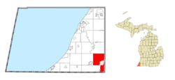
Niles Charter Township has an unusual shape. It has a southern part that extends like an arm, located between the St. Joseph River to the west and Cass County to the east, with the Indiana state line to the south.
Neighboring Areas
Niles Charter Township is surrounded by several other townships:
- To the west and south is Bertrand Township.
- To the west is Buchanan Township.
- To the north is Berrien Township.
- In Cass County, to the northeast is Pokagon Township.
- To the east is Howard Township.
- To the southeast is Milton Township.
- To the south, in St. Joseph County, Indiana, is Clay Township.
- To the southwest is German Township.
Land and Water
According to the United States Census Bureau, Niles Charter Township covers a total area of about 99.4 square kilometers (or 38.4 square miles). Most of this area, about 96.6 square kilometers (37.3 square miles), is land. The remaining 2.8 square kilometers (1.1 square miles), which is about 2.79% of the total area, is water.
Population Information
As of the census in 2020, the total population of Niles Charter Township was 14,417 people. The median age in the township was 39 years old. This means that half the people were younger than 39 and half were older.
See also
 In Spanish: Municipio de Niles (Míchigan) para niños
 | Leon Lynch |
 | Milton P. Webster |
 | Ferdinand Smith |


