Pokagon Township, Michigan facts for kids
Quick facts for kids
Pokagon Township, Michigan
|
||
|---|---|---|
|
||

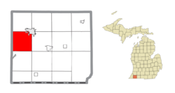
Location within Cass County
|
||
| Country | United States | |
| State | Michigan | |
| County | Cass | |
| Established | 1829 | |
| Area | ||
| • Total | 34.2 sq mi (88.7 km2) | |
| • Land | 34.0 sq mi (88.1 km2) | |
| • Water | 0.2 sq mi (0.6 km2) | |
| Elevation | 751 ft (229 m) | |
| Population
(2020)
|
||
| • Total | 2,119 | |
| • Density | 61.87/sq mi (23.890/km2) | |
| Time zone | UTC-5 (Eastern (EST)) | |
| • Summer (DST) | UTC-4 (EDT) | |
| ZIP code(s) |
49047, 49120
|
|
| Area code(s) | 269 | |
| FIPS code | 26-65300 | |
| GNIS feature ID | 1626922 | |
Pokagon Township is a special kind of local government area called a civil township in Cass County, Michigan. In 2020, about 2,119 people lived here. The township includes two small communities right next to each other: Pokagon and Sumnerville. Both are located along the M-51 highway.
Pokagon Township is famous for a few things. It's where the well-known hymn "The Old Rugged Cross" was first performed in public. It's also the birthplace of Webb Miller, a famous journalist. Plus, the main offices for the Pokagon Band of Potawatomi Indians are located here.
Contents
Exploring Pokagon Township's Location
Pokagon Township is found in the western part of Cass County. It shares its western border with Berrien County. The city of Dowagiac is right on the northeast edge of the township.
Land and Water Features
The total area of Pokagon Township is about 88.7 square kilometers (or 34.2 square miles). Most of this area, about 88.1 square kilometers (34.0 square miles), is land. A small part, about 0.6 square kilometers (0.2 square miles), is water. This means water makes up less than 1% of the township's total area.
The Dowagiac River flows through the western side of the township. This river is a "tributary," which means it's a smaller river that flows into a larger one. The Dowagiac River eventually joins the St. Joseph River.
People of Pokagon Township
| Historical population | |||
|---|---|---|---|
| Census | Pop. | %± | |
| 2000 | 2,199 | — | |
| 2010 | 2,029 | −7.7% | |
| 2020 | 2,119 | 4.4% | |
In 2000, there were 2,199 people living in Pokagon Township. These people lived in 818 households, and 630 of those were families. The population density was about 63.6 people per square mile (24.6 people per square kilometer).
Community Life
About 30% of the households in 2000 had children under 18 living there. Most households, around 63%, were married couples living together. About 19% of all households were made up of people living alone. Also, about 9% of households had someone aged 65 or older living by themselves.
The average household had about 2.59 people. For families, the average size was about 2.93 people.
Age and Income
The people in Pokagon Township had a range of ages in 2000. About 23.6% were under 18 years old. About 15.5% were 65 years or older. The median age, which is the middle age of all the people, was 40 years.
The median income for a household in the township was $38,850. For families, the median income was $41,286. "Median income" means half the households earned more than this amount, and half earned less.
See also
 In Spanish: Municipio de Pokagon para niños
 | Kyle Baker |
 | Joseph Yoakum |
 | Laura Wheeler Waring |
 | Henry Ossawa Tanner |


