
Baroda, Michigan facts for kids
Quick facts for kids
Baroda, Michigan
|
||
|---|---|---|
|
Village
|
||
|
||

Location within Berrien County
|
||

Baroda, Michigan
Location in Michigan
|
||
| Country | United States | |
| State | Michigan | |
| County | Berrien | |
| Township | Baroda | |
| Incorporated | 1907 (village) | |
| Government | ||
| • Type | Village council | |
| Area | ||
| • Total | 0.72 sq mi (1.86 km2) | |
| • Land | 0.72 sq mi (1.86 km2) | |
| • Water | 0.00 sq mi (0.00 km2) | |
| Elevation | 643 ft (196 m) | |
| Population
(2020)
|
||
| • Total | 875 | |
| • Density | 1,220.36/sq mi (471.37/km2) | |
| Time zone | UTC-5 (Eastern (EST)) | |
| • Summer (DST) | UTC-4 (EDT) | |
| ZIP code(s) |
49101
|
|
| Area code(s) | 269 | |
| FIPS code | 26-05500 | |
| GNIS feature ID | 2398036 | |

Baroda is a small village located in Berrien County, in the U.S. state of Michigan. In 2020, about 875 people lived there. The village is part of Baroda Township. It's a quiet community with a rich history.
Contents
History of Baroda Village
Early Settlers and Founding
The first European American settlers arrived in the Baroda area around the 1830s. They worked hard to clear the land, drain swamps, and build homes and farms.
A man named Michael Houser is known as the founder of Baroda. Around 1890, he made a deal with the Indiana and Lake Michigan Railway Company. He convinced them to build a train station on his land. This helped the community grow.
How Baroda Got Its Name
Michael Houser named the village "Baroda" after a city in Gujarat, India, which is now called Vadodara. The village officially became an incorporated village in 1907. The Baroda Post Office opened its doors on January 1, 1891, helping the community connect with the outside world.
Geography of Baroda
Where is Baroda Located?
Baroda is located in southwestern Michigan. According to the United States Census Bureau, the village covers a total area of about 0.72 square miles (1.86 square kilometers). All of this area is land, meaning there are no large lakes or rivers within the village limits.
People Living in Baroda
Population Changes Over Time
The number of people living in Baroda has changed over the years. Here's a quick look at how the population has grown:
| Historical population | |||
|---|---|---|---|
| Census | Pop. | %± | |
| 1910 | 248 | — | |
| 1920 | 223 | −10.1% | |
| 1930 | 291 | 30.5% | |
| 1940 | 302 | 3.8% | |
| 1950 | 344 | 13.9% | |
| 1960 | 488 | 41.9% | |
| 1970 | 504 | 3.3% | |
| 1980 | 627 | 24.4% | |
| 1990 | 657 | 4.8% | |
| 2000 | 858 | 30.6% | |
| 2010 | 873 | 1.7% | |
| 2020 | 875 | 0.2% | |
| U.S. Decennial Census | |||
Baroda's Population in 2010
In 2010, the census showed that 873 people lived in Baroda. There were 381 households and 229 families. This means there were about 1,212.5 people per square mile.
Most people in Baroda were White (95.6%). There were also small percentages of African American, Native American, Asian, and other races. About 2.5% of the population identified as Hispanic or Latino.
Households and Families
About 30.4% of households had children under 18 living with them. Many households (43.6%) were married couples. Some households were led by a single parent. About 33.1% of all households were individuals living alone.
The average age of people in Baroda in 2010 was 37.8 years old. About 24.1% of residents were under 18. About 14% were 65 years old or older. The village had a nearly even split of males (48.8%) and females (51.2%).
Images for kids
-
The official seal of Baroda, Michigan.
-
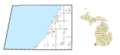
A map showing Baroda's location within Berrien County, Michigan.
See also
 In Spanish: Baroda (Míchigan) para niños
