Lake Charter Township, Michigan facts for kids
Quick facts for kids
Lake Charter Township, Michigan
|
||
|---|---|---|
|
Charter township
|
||
|
||

Location within Berrien County
|
||
| Country | United States | |
| State | Michigan | |
| County | Berrien | |
| Area | ||
| • Total | 18.6 sq mi (48.3 km2) | |
| • Land | 18.6 sq mi (48.2 km2) | |
| • Water | 0.04 sq mi (0.1 km2) | |
| Elevation | 709 ft (216 m) | |
| Population
(2020)
|
||
| • Total | 3,316 | |
| Time zone | UTC-5 (Eastern (EST)) | |
| • Summer (DST) | UTC-4 (EDT) | |
| ZIP code(s) |
49101, 49106, 49125, 49127
|
|
| Area code(s) | 269 | |
| FIPS code | 26-44260 | |
| GNIS feature ID | 1626580 | |
Lake Charter Township is a special type of local government area called a charter township. It is located in Berrien County, which is in the state of Michigan in the United States. In 2020, about 3,316 people lived here.
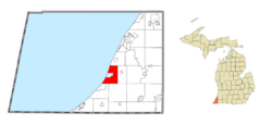
Lake Charter Township is in the western part of Berrien County. To its west, you'll find Lake Michigan and the city of Bridgman. Other nearby areas include Lincoln Township to the north and Baroda Township to the east.
Contents
Exploring Lake Charter Township's Communities
Lake Charter Township is home to a few interesting communities. Some of these have changed a lot over time.
Browntown: A Village from the Past
- Browntown was once a small village within Lake Township.
- It was officially planned out in 1861.
- Today, Browntown no longer exists as a separate village.
Livingston: A Small, Unincorporated Area
- Livingston is a small community that is not officially a town or city.
- It is located where Livington and Gast roads meet.
- This area is just east of I-94 and Red Arrow Highway.
- A post office served Livingston from August 1890 until July 1912.
- Back in 1848, a larger village called Livingston was planned.
- However, this plan never fully happened, and the land became farms.
Understanding Lake Charter Township's Geography
Lake Charter Township covers a total area of about 48.3 square kilometers (18.6 square miles). Most of this area, 48.2 square kilometers (18.6 square miles), is land. Only a small part, about 0.1 square kilometers (0.04 square miles), is water.
I-94, a major highway, runs through the township. It follows along the shore of Lake Michigan. You can also find Warren Dunes State Park in the southwestern part of the township. This park is known for its large sand dunes.
Why Lake Charter Township Experiences Flooding
Lake Charter Township got its name because it has a high water table. This means the ground is naturally very wet. The community was actually built on top of an ancient lake called "Lake Baroda."
Because of the type of soil and how water is managed, the area often experiences flooding. There have been several big floods in recent years, including in 2018, 2020, 2021, and 2023. Sometimes, people have to leave their homes for weeks or months because of the damage. Even though there's a lot of flooding, the area is not officially called a FEMA flood zone. This means residents often cannot get help from the government for the costs of flood damage.
Population and People of Lake Charter Township
The number of people living in Lake Charter Township has changed over the years.
| Historical population | |||
|---|---|---|---|
| Census | Pop. | %± | |
| 2000 | 3,148 | — | |
| 2010 | 2,972 | −5.6% | |
| 2020 | 3,316 | 11.6% | |
| Sources: | |||
In 2000, there were 3,148 people living in the township. Most of the people were White (97.74%). A small number were African American, Native American, or Asian. About 0.92% of the population identified as Hispanic or Latino.
The average household in 2000 had about 2.61 people. Many households (34.8%) had children under 18 living with them. The median age of people in the township was 40 years old. This means half the population was younger than 40, and half was older.
See also
 In Spanish: Municipio de Lake (condado de Berrien) para niños
 | James B. Knighten |
 | Azellia White |
 | Willa Brown |


