Sherwood, Michigan facts for kids
Quick facts for kids
Sherwood, Michigan
|
|
|---|---|
|
Village
|
|
| Village of Sherwood | |

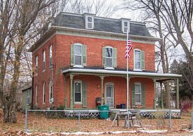
Henry A. Locke House in Sherwood
|
|

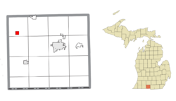
Location within Branch County
|
|
| Country | United States |
| State | Michigan |
| County | Branch |
| Township | Sherwood |
| Settled | 1832 |
| Incorporated | 1887 |
| Government | |
| • Type | Village council |
| Area | |
| • Total | 1.00 sq mi (2.59 km2) |
| • Land | 1.00 sq mi (2.59 km2) |
| • Water | 0.00 sq mi (0.00 km2) |
| Elevation | 879 ft (268 m) |
| Population
(2020)
|
|
| • Total | 285 |
| • Density | 285.00/sq mi (110.04/km2) |
| Time zone | UTC-5 (Eastern (EST)) |
| • Summer (DST) | UTC-4 (EDT) |
| ZIP code(s) |
49089
|
| Area code(s) | 517 |
| FIPS code | 26-73420 |
| GNIS feature ID | 0637777 |
Sherwood is a small village located in Branch County, in the state of Michigan, USA. In 2020, about 285 people lived there. This village is part of Sherwood Township.
Contents
History of Sherwood Village
The area where Sherwood is now was first settled in 1832. It was originally called Hazenville. This name came from the farmland of E. F. Hazen.
Early Names and Post Offices
A post office opened in the community on March 8, 1833. It was first named Durham. Later, on June 10, 1839, the name was changed to Sherwood. The village was named after Alexander Tomlinson. He was one of the first settlers and came from Sherwood Forest in England.
The first Sherwood post office closed in 1866. However, a new post office called Newstead, which started in early 1867, moved to this location. It took over the Sherwood name on April 16, 1868.
Growth and Incorporation
In 1871, the Michigan Central Railroad built a train line through the community. This helped the village grow. Sherwood officially became an incorporated village in 1887.
Geography of Sherwood
According to the U.S. Census Bureau, Sherwood village covers a total area of about 1.00 square mile (2.59 square kilometers). All of this area is land.
The St. Joseph River flows just northwest of the village.
Population Information
| Historical population | |||
|---|---|---|---|
| Census | Pop. | %± | |
| 1880 | 211 | — | |
| 1890 | 447 | 111.8% | |
| 1900 | 366 | −18.1% | |
| 1910 | 346 | −5.5% | |
| 1920 | 250 | −27.7% | |
| 1930 | 282 | 12.8% | |
| 1940 | 281 | −0.4% | |
| 1950 | 362 | 28.8% | |
| 1960 | 356 | −1.7% | |
| 1970 | 400 | 12.4% | |
| 1980 | 353 | −11.7% | |
| 1990 | 320 | −9.3% | |
| 2000 | 324 | 1.3% | |
| 2010 | 309 | −4.6% | |
| 2020 | 285 | −7.8% | |
| U.S. Decennial Census | |||
Sherwood's Population in 2010
In 2010, the village had 309 people living there. There were 106 households and 77 families. The village had about 315 people per square mile. There were 128 housing units in total.
Most of the people living in Sherwood were White (95.1%). A small number were African American (0.6%) or Native American (3.6%). About 0.6% of residents were of two or more races. Less than 1% of the population (0.3%) was Hispanic or Latino.
Households and Families
Out of the 106 households, 40.6% had children under 18 living with them. Half of the households (50.0%) were married couples. About 12.3% had a female head of household with no husband. Another 10.4% had a male head of household with no wife. About 27.4% were non-family households.
Around 20.8% of all households had only one person living there. About 10.4% of households had someone aged 65 or older living alone. The average household had 2.92 people, and the average family had 3.32 people.
Age and Gender in 2010
The average age of people in the village was 39.2 years. About 23.9% of residents were under 18 years old. Around 11.7% were between 18 and 24. People aged 25 to 44 made up 26.6% of the population. Those aged 45 to 64 were 26%. Finally, 12% of the population was 65 years or older.
The village had a nearly equal number of males and females. About 50.5% of the population was male, and 49.5% was female.
See also
 In Spanish: Sherwood (Míchigan) para niños
 | Claudette Colvin |
 | Myrlie Evers-Williams |
 | Alberta Odell Jones |


