
Jonesville, Michigan facts for kids
Quick facts for kids
Jonesville, Michigan
|
|
|---|---|
| City of Jonesville | |
.jpg)
Looking southwest along U.S. Route 12
|
|

Location within Hillsdale County
|
|

Jonesville, Michigan
Location in Michigan

Jonesville, Michigan
Location in the United States
|
|
| Country | United States |
| State | Michigan |
| County | Hillsdale |
| Founded | 1828 |
| Incorporated | 1855 (village) 2014 (city) |
| Government | |
| • Type | Council–manager |
| Area | |
| • Total | 2.83 sq mi (7.33 km2) |
| • Land | 2.79 sq mi (7.23 km2) |
| • Water | 0.03 sq mi (0.10 km2) |
| Elevation | 1,076 ft (328 m) |
| Population
(2020)
|
|
| • Total | 2,176 |
| • Density | 887.46/sq mi (342.65/km2) |
| Time zone | UTC-5 (Eastern (EST)) |
| • Summer (DST) | UTC-4 (EDT) |
| ZIP code(s) |
49250
|
| Area code(s) | 517 |
| FIPS code | 26-41920 |
| GNIS feature ID | 0629385 |
Jonesville is a city located in Hillsdale County, in the state of Michigan, United States. In 2020, about 2,176 people lived here. It is a small but historic city with an interesting past.
Contents
History of Jonesville
Early Settlement and Growth
The area where Jonesville now stands was first settled in 1828. Two brothers, Benaiah and Edmund Jones, came from Painesville, Ohio. They bought land and started planning the community by 1831.
Jonesville became the first county seat for Hillsdale County. A county seat is the main town where the county government is located. The county was officially formed in 1835. The first post office in Jonesville opened on January 21, 1841.
From Village to City
In 1855, Jonesville officially became a village. For many years, it was an important stop on the Lake Shore and Michigan Southern Railway. This railway helped connect Jonesville to other places.
In August 2014, the people of Jonesville voted to become a city. This meant they adopted a new set of rules for their local government.
Historic Places in Jonesville
Jonesville is home to several important historic sites. Three of these places are listed on the National Register of Historic Places. This is a list of buildings, sites, and objects that are important in American history.
These historic sites include:
These three sites are also recognized as Michigan State Historic Sites. Other state historic sites in Jonesville are the Delevan (Munro) House and the Kiddie Brush and Toy Company. The toy company used the same building as the old Carriage Factory. Today, the Carriage Factory building has been updated into apartments.
Geography and Location
Understanding Jonesville's Area
According to the U.S. Census Bureau, Jonesville covers a total area of about 2.83 square miles (7.33 square kilometers). Most of this area, about 2.79 square miles (7.23 square kilometers), is land. A small part, about 0.04 square miles (0.10 square kilometers), is water.
The St. Joseph River flows right through the city. Rivers are often important for a city's history and development.
Main Roads in Jonesville
Two important highways pass through Jonesville:
 US 12: This road, also known as W. Chicago Street, runs southwest through the middle of the city.
 M-99: This highway runs from south to north through Jonesville. For a short distance, it shares the same path as US 12.
Population and People
How Many People Live Here?
The population of Jonesville has changed over the years. Here is a look at the population from different U.S. censuses:
| Historical population | |||
|---|---|---|---|
| Census | Pop. | %± | |
| 1850 | 565 | — | |
| 1860 | 1,008 | 78.4% | |
| 1880 | 1,445 | — | |
| 1890 | 1,288 | −10.9% | |
| 1900 | 1,307 | 1.5% | |
| 1910 | 1,396 | 6.8% | |
| 1920 | 1,274 | −8.7% | |
| 1930 | 1,316 | 3.3% | |
| 1940 | 1,302 | −1.1% | |
| 1950 | 1,594 | 22.4% | |
| 1960 | 1,896 | 18.9% | |
| 1970 | 2,081 | 9.8% | |
| 1980 | 2,172 | 4.4% | |
| 1990 | 2,283 | 5.1% | |
| 2000 | 2,337 | 2.4% | |
| 2010 | 2,258 | −3.4% | |
| 2020 | 2,176 | −3.6% | |
| U.S. Decennial Census | |||
In 2010, there were 2,258 people living in Jonesville. There were 894 households, which are groups of people living together in one home. The average number of people in each household was about 2.41.
Who Lives in Jonesville?
The median age in Jonesville in 2010 was 37.6 years old. This means half the people were younger than 37.6, and half were older.
- About 26.3% of residents were under 18 years old.
- About 17.4% of residents were 65 years old or older.
The population was made up of 47.4% male and 52.6% female residents.
Education in Jonesville
The city of Jonesville has its own school district called Jonesville Community Schools. This district serves students within the city and also from several nearby townships.
Images for kids
-
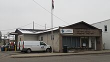
U.S. Post Office in Jonesville -
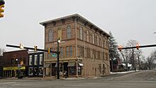
Jonesville City Hall -
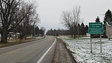
Signage along eastbound US 12 -
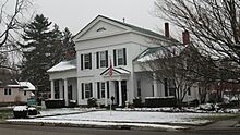
Munro House (built around 1834)


,_Jonesville_Michigan.jpg)
See also
 In Spanish: Jonesville (Míchigan) para niños
