Emmett Charter Township, Michigan facts for kids
Quick facts for kids
Emmett Charter Township, Michigan
|
|
|---|---|
|
Charter township
|
|

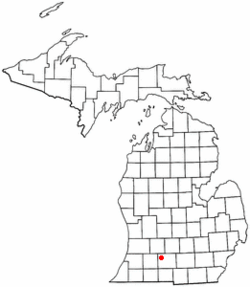
Location of Emmett Charter Township in Michigan
|
|
| Country | United States |
| State | Michigan |
| County | Calhoun |
| Area | |
| • Total | 32.5 sq mi (84.2 km2) |
| • Land | 32.0 sq mi (82.9 km2) |
| • Water | 0.5 sq mi (1.3 km2) |
| Elevation | 889 ft (271 m) |
| Population
(2020)
|
|
| • Total | 11,744 |
| • Density | 361.24/sq mi (139.48/km2) |
| Time zone | UTC-5 (Eastern (EST)) |
| • Summer (DST) | UTC-4 (EDT) |
| FIPS code | 26-25935 |
| GNIS feature ID | 1626239 |
Emmett Charter Township is a special type of charter township located in Calhoun County, in the U.S. state of Michigan. It is part of the larger Battle Creek area. In 2020, about 11,744 people lived in Emmett Charter Township.
Contents
History of Emmett Township
When this area was first organized, it was called Androver Township. Later, in 1839, its name was changed to Emmett Township.
Communities in Emmett Township
Emmett Charter Township is home to several communities. Some of these are "unincorporated communities." This means they are places where people live, but they do not have their own separate city government. They are still part of the larger township.
- The city of Battle Creek is right next to Emmett Township. Some parts of Battle Creek used to be within the township. This includes the former village of Verona.
- Beadle Lake is a community built around a lake. It is located in the western part of the township. Beadle Lake Elementary School is on the southeast side of the lake. A major highway, Interstate 94 (I-94), passes just north of the community.
- Brownlee Park is another unincorporated community within the township. It is a busy area just east of Battle Creek. It also includes the nearby community of Greenfield Park.
- Ceresco is an unincorporated community located on the Kalamazoo River. It sits right on the border between Emmett Township and Marshall Township.
- Sunrise Heights is a neighborhood in the northwest part of the township. It is next to Battle Creek. This area is bordered by several roads and the Kalamazoo River.
- Wattles Park is an unincorporated community within the township. It is centered around Wattles Road, between Michigan Avenue and I-94.
Geography of Emmett Township
Emmett Charter Township covers a total area of about 84.2 square kilometers (which is about 32.5 square miles). Most of this area, about 82.9 square kilometers (32.0 square miles), is land. The remaining 1.3 square kilometers (0.5 square miles) is water, like lakes or rivers.
Population and People
In 2000, there were 11,979 people living in Emmett Charter Township. These people lived in 4,834 households. About 30.6% of these households had children under 18 living with them.
The population was spread out by age:
- About 24.5% of the people were under 18 years old.
- About 8.5% were between 18 and 24 years old.
- About 29.7% were between 25 and 44 years old.
- About 24.5% were between 45 and 64 years old.
- About 12.8% were 65 years old or older.
The average age of people in the township was 37 years.
See also
 In Spanish: Municipio de Emmett (condado de Calhoun) para niños
 | Emma Amos |
 | Edward Mitchell Bannister |
 | Larry D. Alexander |
 | Ernie Barnes |

