
Mosherville, Michigan facts for kids
Quick facts for kids
Mosherville, Michigan
|
|
|---|---|
.jpg)
Intersection of Winfield Road and North Street
|
|

Mosherville, Michigan
Location in Michigan

Mosherville, Michigan
Location in the United States
|
|
| Country | |
| State | |
| County | Hillsdale |
| Township | Scipio |
| Settled | 1838 |
| Platted | 1852 |
| Elevation | 850 ft (260 m) |
| Time zone | UTC-5 (Eastern (EST)) |
| • Summer (DST) | UTC-4 (EDT) |
| ZIP code(s) |
49250 (Jonesville)
49258 |
| Area code(s) | 517 |
| GNIS feature ID | 632744 |
Mosherville is a small, quiet place in Hillsdale County, Michigan. It's known as an "unincorporated community." This means it doesn't have its own official city government or exact borders like a town or city. Instead, it's part of a larger area called Scipio Township.
Even though Mosherville doesn't have its own population count, it does have its own post office. This post office uses the ZIP Code 49258, mostly for post office box services.
Contents
Where is Mosherville?

Mosherville is located in the northern part of Scipio Township. This is in the north-central area of Hillsdale County. It's about 25 miles (40 km) southeast of a city called Coldwater.
The community is about 0.5 miles (0.8 km) south of the line that separates Hillsdale County from Jackson County. Mosherville is a rural area, meaning it's mostly countryside. It doesn't have big highways or airports nearby.
- To the west, you'll find Litchfield.
- Jonesville is to the south.
- The village of Hanover is to the northeast.
- Other small communities nearby include Pulaski to the north, Stoney Point to the northeast, and Moscow to the east.
Mosherville Lake is the biggest lake in the area. There are also several smaller lakes nearby that don't have names. The south branch of the Kalamazoo River flows right through Mosherville. The new Scipio Township Hall is located in Mosherville at 11180 Concord Road.
Students in Mosherville attend schools in the Jonesville Community Schools district, which is located south in the city of Jonesville. The Mosherville post office is at 11200 Winfield Road. While it uses the 49258 ZIP Code for post office boxes, mail delivery for the surrounding area comes from the Jonesville post office, which uses the 49250 ZIP Code.
A Look at Mosherville's Past

The Mosherville area was first settled way back in 1838. A man named David Mosher from New York was one of the first to arrive. His brothers, Charles, James, and Giles, later joined him. David eventually went back to New York, but his brothers stayed. They built a sawmill and a grist mill, which were important for processing wood and grain.
A post office first opened here on July 2, 1849. It was originally named Scipio, after the township. The community was officially mapped out in 1852 and grew more in 1856. For a short time, the post office was called Tylerville. However, by 1857, maps showed the area as Mosherville. On April 20, 1858, the post office was officially renamed Mosherville.
In 1899, a company called Omega Portland Cement Company started operating near Mosherville, by Cobb Lake. The many small lakes in the area had special mud (sediments) needed to make Portland cement, which is used in concrete. The company built several buildings in Mosherville. They would dig up the sediments from the lakes and send them to Millbury, Ohio, for more processing. This company stopped working in 1914.
Mosherville also used to have a train station. It was part of the Fort Wayne and Jackson Railroad, which was a branch of the New York Central Railroad. The train station was still running in 1923, but today, the station and train tracks are gone from Mosherville. There was even another community called East Mosherville, just to the east, which also had its own train station. While Mosherville is still an active community, East Mosherville has become a ghost town, meaning it's mostly deserted.
Mosherville Church and School Complex
Two of the most important old buildings in Mosherville are the Mosherville Church and the Mosherville School. These two buildings together were recognized as a special Michigan State Historic Site on April 24, 1979. The next year, a historical marker was put up to tell their story.
The church is located at 1520 North Street. It was built between 1861 and 1862 on land given by Joseph and Mary Riggs. It started as a branch of a Methodist Episcopal Church from Litchfield. In 1870, it became its own independent church. In 1891, the Ladies' Aid Society helped expand the church. The Mosherville Church is still active today and holds weekly services for everyone.
The Mosherville School started in 1847. Its first school building was built in 1857–1858. The current school building was built next to the church in 1872 and cost $2,800. It was the oldest school in Scipio Township. It was a two-room schoolhouse that taught students from first grade all the way up to tenth grade. Later, it only taught eighth graders. The school closed in 1967. After that, the Ladies' Aid Society used it, and now it serves as a fellowship hall for the Mosherville Church.
Images for kids
-
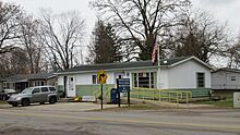
U.S. Post Office in Mosherville -
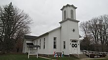
Mosherville Church -
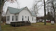
Mosherville School

.jpg)
.jpg)
