
Allendale, Michigan facts for kids
Quick facts for kids
Allendale, Michigan
|
|
|---|---|

Location of Allendale, Michigan
|
|
| Country | United States |
| State | Michigan |
| County | Ottawa |
| Area | |
| • Total | 24.15 sq mi (62.54 km2) |
| • Land | 23.23 sq mi (60.18 km2) |
| • Water | 0.91 sq mi (2.36 km2) |
| Elevation | 653 ft (199 m) |
| Population
(2020)
|
|
| • Total | 27,073 |
| • Density | 1,165.18/sq mi (449.88/km2) |
| Time zone | UTC-5 (Eastern (EST)) |
| • Summer (DST) | UTC-4 (EDT) |
| ZIP code |
49401 (Allendale)
|
| Area code(s) | 616 |
| FIPS code | 26-01340 |
| GNIS feature ID | 1626370 |
Allendale is a community in Ottawa County, in the state of Michigan, USA. It is known as a census-designated place (CDP), which means it's an area the government counts for population statistics.
In 2020, about 27,073 people lived in Allendale. It's part of a larger area that includes Grand Rapids. Many people who live in Allendale travel to Grand Rapids for work or school.
The name Allendale comes from Allendale Charter Township. The township was named after Agnes Allen. She was the first person to pay taxes in the area. Agnes was the widow of Hannibal Allen, whose father was Ethan Allen, a hero from the American Revolutionary War.
Allendale is also home to the main campus of Grand Valley State University.
Contents
Exploring Allendale's Location
Allendale is located in the western part of Michigan. It covers about 24 square miles (62 square kilometers). Most of this area is land, but about 0.9 square miles (2.36 square kilometers) is water.
Water Features in Allendale
Who Lives in Allendale?
Allendale has grown quite a bit over the years. In 2000, there were about 11,555 people. By 2020, the population had grown to 27,073 people.
The community has a mix of ages. Many young people live here because of the university. The average age in Allendale in 2000 was 21 years old.
Learning in Allendale
Allendale offers many schools for students of all ages.
Schools for Kids and Teens
Allendale has its own public school system, called Allendale Public Schools.
- Allendale High School
- New Options Alternative High School
- Allendale Middle School
- Oakwood Intermediate School
- Springview Elementary
- Evergreen Elementary
- Allendale Christian School
Higher Education Opportunities
Grand Valley State University (GVSU) has its main campus in Allendale. It was started in 1960. The university is quite large, covering about 1,237 acres. GVSU is known for growing quickly in both student numbers and buildings. It offers over 200 different study programs. Nearly 25,000 students attend GVSU across its campuses.
Allendale Parks and Recreation
Allendale Community Park is a large park, about 40 acres in size. It has a special area called the Veterans Garden of Honor. This garden celebrates U.S. soldiers with nine statues. One statue, put in place in 1998, shows soldiers from different sides of a past conflict. This statue has caused some discussion in the community.
Cool Places to Visit
On the University Campus
- Lubbers Stadium: This is where the Grand Valley State Laker football team plays.
- Cook Carillon Tower: A tall tower with bells that play music.
- The Meadows at Grand Valley State University: A golf course.
- GVSU Fieldhouse: A large sports facility.
Around Allendale
- Grand River: A major river for outdoor activities.
- Bass River State Recreation Area: A place for nature and outdoor fun.
- Placid Wake Park: A park for water sports.
- Grand River Park
Allendale's Local Media
You can find local news and entertainment in Allendale through different media.
Newspapers
- Grand Valley Lanthorn: The student newspaper for GVSU.
Radio Stations
- WGVU-FM (88.5 FM): This is GVSU's public radio station, playing jazz and NPR programs.
- WCKS "The Whale": A radio station run by GVSU students.
Television Channels
- WGVU-TV: GVSU's PBS TV station.
- GVBN: A TV station run by GVSU students.
Getting Around Allendale
Public Transportation
- Interurban Transit Partnership (The Rapid): This bus system helps people travel around Allendale, GVSU, and nearby areas like Grand Rapids. It connects the Allendale campus with GVSU's other campus in Grand Rapids.
Main Roads
 M-45 (Lake Michigan Drive): A major highway that goes through Allendale.
Images for kids
-
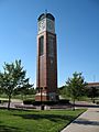
The Cook Carillon Tower at Grand Valley State University.
-
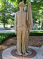
A monument in the Veterans Garden of Honor at Allendale Community Park.
-
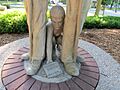
A detail of a statue in the Veterans Garden of Honor.


See also
 In Spanish: Allendale (Míchigan) para niños
