Manistee River facts for kids
Quick facts for kids Manistee River |
|
|---|---|
 |
|
| Physical characteristics | |
| Main source | Mancelona Township, Antrim County, Michigan 1,250 ft (380 m) 44°56′06″N 84°52′06″W / 44.93501°N 84.86837°W |
| River mouth | Lake Michigan 579 ft (176 m) 44°15′00″N 86°20′40″W / 44.25°N 86.34453°W |
| Length | 190 mi (310 km) |
| Basin features | |
| Basin size | 1,780 sq mi (4,600 km2) |
| Type: | Recreational |
| Designated: | March 3, 1992 |
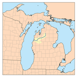
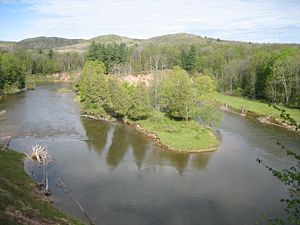
The Manistee River is a cool river in Michigan, a state in the United States. It flows for about 190 miles (310 km) (or 306 kilometres (190 mi)) through the northwestern part of Michigan's Lower Peninsula. The river starts in Antrim County and ends up in Lake Michigan at a town called Manistee. People think it's one of the best places to catch trout fish east of the Rocky Mountains!
The river begins in sandy hills in southeastern Antrim County. These deep sands help keep the water clean and cold all year. This makes the Manistee River a great spot for fishing and canoeing. The river drops from about 1,250 feet (380 m) (381 metres (1,250 ft)) high to 579 feet (176 m) (176 metres (577 ft)) high by the time it reaches Lake Michigan.
Contents
River's Past: How the Manistee Got Its Name
The name "Manistee" comes from an Ojibwe word. We aren't totally sure what it means. But it might mean "river with islands at its mouth."
Long ago, the Ojibwe (also called Chippewa) and Ottawa people lived along this river. The Ottawa people even had a special area, called a reservation, on the river starting in 1836. Today, the Little River Band of Ottawa Indians still lives on their land in Manistee County.
Logging History and Its Impact
In the past, the upper part of the river was famous for its amazing grayling fish. People used to catch more than 1,000 fish in just one weekend! But this changed in the 1880s.
Around that time, settlers from Europe started cutting down a lot of trees. This is called logging. Between 1880 and 1910, many trees were cut down. This logging hurt the river's environment. Dirt and wood pieces got into the water, making it dirty.
The Manistee River was perfect for moving logs. It was wide, flowed smoothly, and didn't have many difficult spots. Huge white pine logs, some as big as 6 feet (1.8 m) (1.8 metres (5 ft 11 in)) across, floated down the river. They went to cities like Grand Rapids, Milwaukee, and Chicago. This wood helped build many towns and cities in the Midwestern United States. You can still see some of these old logs stuck at the bottom of the river today!
Manistee River's Natural Environment
The Manistee River State Game Area is a special place along the river. It has marshlands and small water channels called bayous. This area is managed by the Michigan Department of Natural Resources. It covers about 3,920 acres (about 1,586 hectares).
Wildlife in the Marshlands
The Manistee River State Game Area is home to many animals. The marshlands and nearby forests are great places for wood ducks to live. Wood ducks build their nests in tree holes. They eat acorns, seeds, berries, insects, and water plants.
Many other wetland animals also live here. These marshlands are important for ducks, geese, herons, and other birds that nest or stop here during their long journeys. You can also find muskrats, mink, frogs, turtles, and snakes in these wet areas.
Fighting Invasive Plants
Workers are busy removing plants that don't belong here. One of these is called phragmites, also known as common reed. This tall grass can grow up to 15 feet (4.6 m) (4.6 metres (15 ft)) high.
Invasive phragmites can harm the wetlands. It grows very thick, pushing out native plants and animals. It can also block views of the shoreline and make it harder to go swimming, fishing, or hunting. Plus, the dry phragmites plants can be a fire danger.
A special project, funded by the Great Lakes Restoration Initiative, is helping to restore the Manistee Marsh. By reducing the phragmites, they can create a "hemi-marsh." This is a mix of half plants and half open water, which is very good for waterfowl like ducks and geese.
These wetlands are open for everyone to enjoy. You can go hiking, canoeing, kayaking, taking pictures of wildlife, fishing, and birdwatching. It's a great place to spend a day exploring!
Fun Activities on the Manistee River
Today, many people use the Manistee River for fun activities. It's an excellent place for canoeing, boating, and fishing. After the logging era, the river has been cleaned up. Now, it's considered one of the best rivers in the country for catching trout and salmon. Bigger boats can even travel on the lower parts of the river, below the Tippy Dam.
Manistee River Bridges
| Route | Type | City | County | Location |
|---|---|---|---|---|
| Maple Street | City Street | Manistee | Manistee | |
| Cypress Street | City Street | |||
| M-55 | Michigan Highway | |||
| North High Bridge Road | County Road | |||
| County Road 115 | County Highway | Wexford | ||
| M-37 | Michigan Highway | |||
| US-131 | US Route | 44°29′3.18″N 85°24′22.82″W / 44.4842167°N 85.4063389°W | ||
| West Farney Road | County Road | Missaukee | ||
| Coster Road Southwest | County Road | Kalkaska | ||
| County Road 66 | County Road | |||
| West Sharon Road | County Road | |||
| County Road 571 | County Road | |||
| Sunset Trail Southeast | County Road | |||
| M-72 | Michigan Highway | Crawford | 44°41′34.29″N 84°50′50.55″W / 44.6928583°N 84.8473750°W |
 | Madam C. J. Walker |
 | Janet Emerson Bashen |
 | Annie Turnbo Malone |
 | Maggie L. Walker |


