Treaty of Washington (1836) facts for kids
The Treaty of Washington was an important agreement made in 1836 between the United States government and leaders from the Ottawa and Chippewa Native American nations. This treaty involved a huge amount of land in what is now the state of Michigan.
Contents
What Was the Treaty of Washington (1836)?
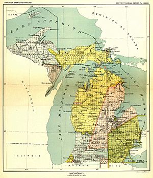
This treaty meant that the Ottawa and Chippewa tribes gave up control of about 13.8 million acres of their land. That's a massive area, almost 56,000 square kilometers! This land was located in the northwest part of Michigan's Lower Peninsula and the eastern part of its Upper Peninsula. This area makes up about 37% of the land in Michigan today.
Who Signed the Treaty?
The treaty was officially signed on March 28, 1836. It happened in Washington D.C., the capital of the United States.
- For the United States, the main person who signed was Henry Schoolcraft. He was the Indian Commissioner, which meant he worked for the government on matters related to Native Americans.
- Many leaders and representatives from the Ottawa and Chippewa nations also signed the treaty.
The treaty was then officially announced on May 27, 1836.
Where Was the Land Located?
The treaty described the exact boundaries of the land that was given up. It's a bit like drawing a big shape on a map!
Starting Point
The boundary started at the mouth of the Grand River on its north side. This river is in Michigan.
Following Rivers and Lines
- From the Grand River, the line went east until it met areas from older treaties (the 1821 Treaty of Chicago and the 1819 Treaty of Saginaw). This spot is near Saranac and Lowell in Ionia County today.
- Then, the boundary went in a straight line to the start of the Thunder Bay River. This is in Montmorency County, between Lewiston and Atlanta.
- The line followed the Thunder Bay River all the way to where it flows into Lake Huron.
- From there, it went northeast to the border between the United States and Canada.
- It followed this international border through the St. Mary's River into Lake Superior.
Across the Upper Peninsula
- The boundary then went to a point in Lake Superior, north of a river called Gitchy Seebing (also known as the Chocolay River). This is near Marquette in Marquette County.
- It followed the Chocolay River to its source, which is near Gwinn.
- From there, it continued in a straight line to the start of the Escanaba River.
- The line then followed the south bank of the Escanaba River to where it flows into the Little Bay de Noc, near Escanaba.
Back to the Start
- Finally, the boundary went through the shipping channel into Green Bay and then through Lake Michigan.
- It went to a point west of the Grand River's mouth and then due east, right back to where it started!
 | Janet Taylor Pickett |
 | Synthia Saint James |
 | Howardena Pindell |
 | Faith Ringgold |


