Lowell, Michigan facts for kids
Quick facts for kids
Lowell, Michigan
|
|
|---|---|
| City of Lowell | |

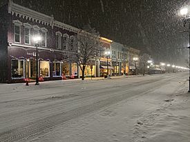
Historic district along Main Street (M-21)
|
|

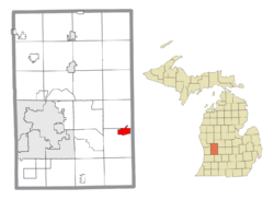
Location within Kent County
|
|
| Country | United States |
| State | Michigan |
| County | Kent |
| Founded | 1831 |
| Government | |
| • Type | Mayor–council |
| Area | |
| • Total | 3.10 sq mi (8.03 km2) |
| • Land | 2.88 sq mi (7.46 km2) |
| • Water | 0.22 sq mi (0.57 km2) |
| Elevation | 640 ft (200 m) |
| Population
(2020)
|
|
| • Total | 4,142 |
| • Density | 1,438.19/sq mi (555.29/km2) |
| Time zone | UTC-5 (Eastern (EST)) |
| • Summer (DST) | UTC-4 (EDT) |
| ZIP code(s) |
49331
|
| Area code(s) | 616 |
| FIPS code | 26-49540 |
| GNIS feature ID | 1626644 |
Lowell is a friendly city located in Kent County, in the state of Michigan, United States. As of the 2020 census, about 4,142 people call Lowell home.
This city is part of the larger Grand Rapids metropolitan area and is situated about 15 miles (24 km) east of Grand Rapids. Lowell is special because it sits just north of where the Flat River flows into the Grand River. Even though it's surrounded by Lowell Township, Lowell manages its own city affairs. Its charming downtown area is so important that it's recognized as a historic district.
Contents
Discovering Lowell's Past
Early Inhabitants: The Odawa People
Long ago, the land around the Flat River and Grand River was home to the Grand River Odawa, a Native American tribe. They had several villages along the Grand River. In the early 1800s, leaders like Wabiwindego, Keewaycooshcum, and later Cobmoosa guided these villages. In the 1830s, Cobmoosa bought land for his people where their village stood. The Odawa lived there until 1858, when they moved to a reservation in Manistee, Michigan.
How Lowell Began
The city we know today as Lowell started in 1831. A man named Daniel Marsac set up a trading post on the south bank of the Grand River. He traded with the Odawa village that was already there. For a few years, Marsac even lived with the Odawa leader Wabiwindego.
Later, in 1847, Marsac bought land on the north side of the river. He planned and mapped out this new area, calling it "Dansville." In 1851, a post office opened there and was named "Lowell," after the surrounding township. The community was re-planned in 1854 and officially took the name "Lowell" from the post office. It became an official village in 1861.
Exploring Lowell's Geography
Land and Water
Lowell covers a total area of about 3.10 square miles (8.03 square kilometers). Most of this area, about 2.88 square miles (7.46 square kilometers), is land. The rest, about 0.22 square miles (0.57 square kilometers), is water.
Nature and Trails
Lowell is proud to be the home of the North Country Trail Association. This amazing trail runs just north of downtown Lowell and follows parts of the Flat River. It's a great place for outdoor adventures!
Main Roads
- M-21 is a major highway that goes through the middle of Lowell, running east and west.
Lowell's Climate
Lowell experiences a type of weather called a humid continental climate. This means the city has big changes in temperature throughout the year. Summers are usually warm to hot, and sometimes humid. Winters are cold, and can sometimes be very cold.
Lowell's Community: Who Lives Here?
Lowell has seen its population grow over the years.
| Historical population | |||
|---|---|---|---|
| Census | Pop. | %± | |
| 1860 | 547 | — | |
| 1870 | 1,503 | 174.8% | |
| 1880 | 1,538 | 2.3% | |
| 1890 | 1,829 | 18.9% | |
| 1900 | 1,736 | −5.1% | |
| 1910 | 1,761 | 1.4% | |
| 1920 | 1,730 | −1.8% | |
| 1930 | 1,919 | 10.9% | |
| 1940 | 1,944 | 1.3% | |
| 1950 | 2,191 | 12.7% | |
| 1960 | 2,545 | 16.2% | |
| 1970 | 3,068 | 20.6% | |
| 1980 | 3,707 | 20.8% | |
| 1990 | 3,983 | 7.4% | |
| 2000 | 4,013 | 0.8% | |
| 2010 | 3,783 | −5.7% | |
| 2020 | 4,142 | 9.5% | |
| U.S. Decennial Census | |||
According to the 2020 census, 4,142 people lived in Lowell. The city is a mix of different people and families. Many households include children under 18. The average age in Lowell is around 37 years old.
Fun Things to Do in Lowell: Parks and More!
Lowell has several parks where you can play and relax:
| Lowell Parks | Location |
|---|---|
| Creekside Park | Located in the 1600 block of Gee Dr. |
| Recreation Park | Located in the 300 block of S. Broadway St. |
| Richards Park | Located in the 300 block of N. Hudson St. |
| Stoney Lakeside Park | Located in the 1200 block of Bowes Rd. |
| Lowell Dog Park | Located in the 1200 block of Bowes Rd. |
Learning in Lowell: Schools for Everyone
The Lowell Area Schools district serves the community. Students in the city attend Bushnell and Cherry Creek elementary schools. For older students, Lowell Middle School and Lowell High School welcome students from the entire school district.
Famous Faces from Lowell
Many interesting people have connections to Lowell:
- William Seward Burroughs I: He invented the adding machine and founded the Burroughs Corporation. He lived in Lowell in the 1860s and graduated from Lowell High School.
- Cobmoosa: A leader of the Odawa people who operated a trading post where Lowell is today.
- Mike Dumas: A professional football player who is now retired.
- Mabel Gillespie: A farmer, teacher, journalist, and politician who lived in Lowell for many years.
- Ernest R. Graham: An architect born in Lowell. He designed famous buildings in Chicago, like the Wrigley Building and the Shedd Aquarium.
- Jennie Harris Oliver: A poet who was born in Lowell.
- Dave Hildenbrand: A politician from Michigan.
- Anthony Kiedis: The lead singer of the famous band Red Hot Chili Peppers.
- Howard Henry Peckham: A professor and historian who graduated from Lowell High School.
- Ann Rule: An author of true crime novels, born in Lowell, Michigan.
- John Addison Scott: A U.S. Navy Rear Admiral and a recipient of the Navy Cross award.
- Glendon Swarthout: A novelist who graduated from Lowell High School.
- Daniel Vosovic: A fashion designer who also graduated from Lowell High School.
See also
 In Spanish: Lowell (Míchigan) para niños
 | Mary Eliza Mahoney |
 | Susie King Taylor |
 | Ida Gray |
 | Eliza Ann Grier |


