Lewiston, Michigan facts for kids
Quick facts for kids
Lewiston, Michigan
|
|
|---|---|

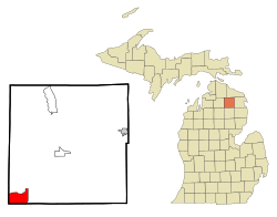
Location in Montmorency County and the state of Michigan
|
|
| Country | |
| State | |
| County | Montmorency |
| Township | Albert |
| Area | |
| • Total | 4.12 sq mi (10.66 km2) |
| • Land | 2.83 sq mi (7.34 km2) |
| • Water | 1.28 sq mi (3.32 km2) |
| Elevation | 1,243 ft (379 m) |
| Population
(2020)
|
|
| • Total | 996 |
| • Density | 351.45/sq mi (135.68/km2) |
| Time zone | UTC-5 (Eastern (EST)) |
| • Summer (DST) | UTC-4 (EDT) |
| ZIP code |
49756
|
| Area code(s) | 989 |
| FIPS code | 26-47260 |
| GNIS feature ID | 0630355 |
Lewiston is a small community in Montmorency County, Michigan, United States. It is not an official city or town, but it is a special area called a census-designated place (CDP). This means it has clear borders for counting people. In 2020, about 996 people lived in Lewiston.
History of Lewiston
Lewiston officially started in 1892. The first post office opened on April 25, 1892.
You can visit the Lewiston Area Historical Society Museum. It is in an old home from 1892. This house first belonged to David Kneeland. He was the manager of a lumber company called Michelson & Hanson. His family lived in Lewiston from 1892 to 1910.
When the lumber mill closed, the Kneeland family sold their home to George and Martha Sachs. The Sachs family helped make the town bigger and set its current boundaries. Lewiston is also known as "Timber Town" because of its history with lumber.
Geography and Location
Lewiston is located in the southwestern part of Montmorency County. It is in western Albert Township, Michigan. The community is next to Oscoda County, Michigan on its south side.
Lewiston is about 16 miles southwest of Atlanta, Michigan. Atlanta is the main town of Montmorency County. It is also about 27 miles southeast of Gaylord, Michigan.
The community is mainly on the north side of East Twin Lake. However, the area defined for counting people (the CDP) goes all the way around the entire lake.
The total area of Lewiston is about 4.1 square miles. About 2.8 square miles of this is land, and 1.3 square miles is water. This means about 38% of Lewiston's area is water. East Twin Lake and West Twin Lake are part of the Au Sable River system. This river flows into Lake Huron.
Population and People
| Historical population | |||
|---|---|---|---|
| Census | Pop. | %± | |
| 2000 | 990 | — | |
| 2010 | 1,392 | 40.6% | |
| 2020 | 996 | −28.4% | |
| U.S. Decennial Census | |||
In 2000, there were 990 people living in Lewiston. By 2010, the population grew to 1,392 people. In 2020, the population was 996.
In 2010, there were slightly more females than males living in Lewiston. There were 718 females and 674 males. Most households in Lewiston are families. Many of these are married couples living together. About 19% of households had children under 18 years old.
The average income for people in Lewiston was about $31,576 in 2010.
See also
 In Spanish: Lewiston (Míchigan) para niños
 | James Van Der Zee |
 | Alma Thomas |
 | Ellis Wilson |
 | Margaret Taylor-Burroughs |

