Missaukee County, Michigan facts for kids
Quick facts for kids
Missaukee County
|
|
|---|---|

Missaukee County Courthouse in Lake City
|
|

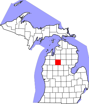
Location within the U.S. state of Michigan
|
|
 Michigan's location within the U.S. |
|
| Country | |
| State | |
| Founded | 1840 (created) 1871 (organized) |
| Seat | Lake City |
| Largest city | Lake City |
| Area | |
| • Total | 574 sq mi (1,490 km2) |
| • Land | 565 sq mi (1,460 km2) |
| • Water | 9.1 sq mi (24 km2) 1.6%% |
| Population
(2020)
|
|
| • Total | 15,052 |
| • Density | 26/sq mi (10/km2) |
| Time zone | UTC−5 (Eastern) |
| • Summer (DST) | UTC−4 (EDT) |
| Congressional district | 1st |
Missaukee County is a county located in the state of Michigan in the United States. In 2020, about 15,052 people lived here. The main town and county seat is Lake City.
Missaukee County is part of the Cadillac area. This area is known as a "micropolitan statistical area." It is also considered to be part of Northern Michigan.
Contents
History of Missaukee County
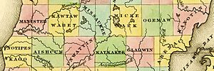
Missaukee County was first created on April 1, 1840. It was separated from Mackinac County. People expected more people to move to the area.
Later, for legal reasons, Missaukee County was linked to other counties. It was connected to Grand Traverse County in 1851. Then it was linked to Manistee County in 1855. Finally, it was linked to Wexford County in 1869. The county officially started to govern itself in 1871.
What Does "Missaukee" Mean?
The name Missaukee County might come from a famous Ottawa chief. His name was Nesaukee. He signed important agreements in 1831 and 1833.
However, some people say "Nesaukee" could also mean 'large mouth of the river'. This refers to a place where a big river flows into a lake or another river.
Geography of Missaukee County
Missaukee County covers a total area of about 574 square miles. Most of this area, 565 square miles, is land. The rest, about 9.1 square miles, is water. This means about 1.6% of the county is water.
Lakes and Rivers in Missaukee County
Missaukee County has 33 natural freshwater lakes. The biggest lake is Lake Missaukee. It covers about 1,800 acres.
Many lakes and streams in the county flow into the Muskegon River. This river flows from north to south through the eastern part of the county. The Clam River is another important river. It is about 51 miles long and flows from west to east. It is a branch of the Muskegon River.
The Reedsburg Dam is also located in Missaukee County. The Manistee River flows through the far northwest part of the county.
Main Roads in Missaukee County
- M-42 is a short road that goes east to west. It connects M-66 near Lake City to US Highway 131 in Manton.
- M-55 is a road that goes east to west across the entire Lower Peninsula.
- M-66 is a road that goes north to south. It runs from the Indiana border all the way to US Highway 31 in Charlevoix.
Neighboring Counties
Missaukee County shares borders with several other counties:
- Kalkaska County to the north
- Crawford County to the northeast
- Roscommon County to the east
- Clare County to the southeast
- Osceola County to the southwest
- Wexford County to the west
- Grand Traverse County to the northwest
Communities in Missaukee County
Missaukee County has two main cities and many smaller towns and communities.
Cities in Missaukee County
Townships in Missaukee County
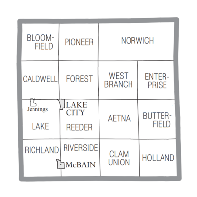
A township is a type of local government area. Missaukee County has several townships:
- Aetna Township
- Bloomfield Township
- Butterfield Township
- Caldwell Township
- Clam Union Township
- Enterprise Township
- Forest Township
- Holland Township
- Lake Township
- Norwich Township
- Pioneer Township
- Reeder Township
- Richland Township
- Riverside Township
- West Branch Township
Other Communities in Missaukee County
These are smaller places that are not officially cities or townships:
People of Missaukee County
| Historical population | |||
|---|---|---|---|
| Census | Pop. | %± | |
| 1870 | 130 | — | |
| 1880 | 1,553 | 1,094.6% | |
| 1890 | 5,048 | 225.0% | |
| 1900 | 9,308 | 84.4% | |
| 1910 | 10,606 | 13.9% | |
| 1920 | 9,004 | −15.1% | |
| 1930 | 6,992 | −22.3% | |
| 1940 | 8,034 | 14.9% | |
| 1950 | 7,458 | −7.2% | |
| 1960 | 6,784 | −9.0% | |
| 1970 | 7,126 | 5.0% | |
| 1980 | 10,009 | 40.5% | |
| 1990 | 12,147 | 21.4% | |
| 2000 | 14,478 | 19.2% | |
| 2010 | 14,849 | 2.6% | |
| 2020 | 15,052 | 1.4% | |
| 2023 (est.) | 15,311 | 3.1% | |
| U.S. Decennial Census 1790-1960 1900-1990 1990-2000 2010-2018 |
|||
In 2000, there were 14,478 people living in Missaukee County. There were 5,450 households, which are groups of people living together. About 4,043 of these were families. The population density was about 26 people per square mile.
Most people in the county were White (97.50%). A smaller number were Native American (0.50%) or Asian (0.24%). About 1.17% of the people were Hispanic or Latino. Many people had Dutch (24.6%), German (18.3%), or English (10.0%) backgrounds. Most people (97.9%) spoke English.
By 2020, the population grew to 15,052 people. Most residents were still non-Hispanic white.
In 2000, the average income for a household was $35,224. For a family, it was $39,057. About 10.70% of all people in the county lived below the poverty line. This included 13.20% of those under 18 years old.
Religions in Missaukee County
The Christian Reformed Church in North America is the largest religious group in Missaukee County. In 2000, it had 2,010 members and 7 churches. This means almost half of the county's population belonged to this church.
Other religious groups include the Reformed Church in America, with 3 churches and 830 members. The United Methodist Church had 3 churches and 500 members. The county also has Catholic churches, with 1 church and 800 members. There is also an Amish community in the county. It started in 2000.
Education in Missaukee County
The Wexford–Missaukee Intermediate School District helps schools in the county. This district is based in Cadillac. It offers special education services and career programs for students.
Missaukee County has two main public school districts:
- Lake City Area School District
- McBain Rural Agricultural Schools
There is also one private school in Missaukee County. It is called Northern Michigan Christian School.
See also
 In Spanish: Condado de Missaukee para niños
 | Dorothy Vaughan |
 | Charles Henry Turner |
 | Hildrus Poindexter |
 | Henry Cecil McBay |


