Falmouth, Michigan facts for kids
Quick facts for kids
Falmouth, Michigan
|
|
|---|---|

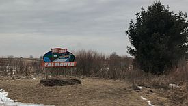
Welcome sign to Falmouth (February 2018)
|
|
| Country | United States |
| State | Michigan |
| County | Missaukee |
| Township | Clam Union |
| Settled | 1871 |
| Area | |
| • Total | 0.68 sq mi (1.76 km2) |
| • Land | 0.68 sq mi (1.76 km2) |
| • Water | 0.00 sq mi (0.00 km2) |
| Population
(2020)
|
|
| • Total | 183 |
| • Density | 269.12/sq mi (103.95/km2) |
| Time zone | UTC-5 (Eastern (EST)) |
| • Summer (DST) | UTC-4 (EDT) |
| ZIP Code |
49632
|
| Area code(s) | 231 |
| GNIS feature ID | 625817 |
| FIPS code | 26-27320 |
Falmouth is a small community in Michigan, United States. It is located in Missaukee County, within Clam Union Township. In 2020, about 183 people lived there. Falmouth is known as an "unincorporated community." This means it is a recognized area but does not have its own separate local government like a city or town. It is also a "census-designated place" (CDP), which means the U.S. Census Bureau counts its population.
A Look Back in Time
Falmouth started as a place where people worked with wood. They cut down trees for lumber. It was first known as Pinhook. A post office opened here on December 18, 1871. Eugene W. Watson was the first person in charge of the mail.
In 1873, Falmouth almost became the main town, or "county seat," for Missaukee County. But it lost by just one vote to a place called Reeder. Reeder is now known as Lake City. In 1879, John Koopman built a store in Falmouth. Two years later, in 1881, he bought the whole village area. This included its saw, shingle, and grist mills.
Where is Falmouth?
Falmouth is in the southern part of Missaukee County. It is in the northwest corner of Clam Union Township. By road, it is about 12 miles southeast of Lake City. Lake City is the county seat. Falmouth is also about 9 miles northeast of McBain.
The Falmouth area covers about 0.68 square miles. All of this area is land. The Clam River flows along the southwest edge of the community. This river flows south and is a smaller stream that feeds into the Muskegon River.
How Many People Live Here?
This section shows how the number of people living in Falmouth has changed over time.
| Historical population | |||
|---|---|---|---|
| Census | Pop. | %± | |
| 2020 | 183 | — | |
| U.S. Decennial Census | |||
Getting Around
Several main roads help people get to and from Falmouth. These roads include Prosper Road to the east and 7 Mile Road to the northeast. Forward Road runs to the north and south. Falmouth Road is located to the west.
 | James Van Der Zee |
 | Alma Thomas |
 | Ellis Wilson |
 | Margaret Taylor-Burroughs |


