Clam Union Township, Michigan facts for kids
Quick facts for kids
Clam Union Township, Michigan
|
|
|---|---|

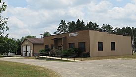
Clam Union Township Hall and Fire Department
|
|

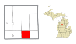
Location within Missaukee County and the state of Michigan
|
|
| Country | United States |
| State | Michigan |
| County | Missaukee |
| Area | |
| • Total | 36.00 sq mi (93.2 km2) |
| • Land | 35.59 sq mi (92.2 km2) |
| • Water | 0.41 sq mi (1.1 km2) |
| Elevation | 1,142 ft (348 m) |
| Population
(2020)
|
|
| • Total | 907 |
| • Density | 25.5/sq mi (9.8/km2) |
| Time zone | UTC-5 (Eastern (EST)) |
| • Summer (DST) | UTC-4 (EDT) |
| ZIP Codes | |
| Area code(s) | 231 |
| FIPS code | 26-113-15900 |
| GNIS feature ID | 1626084 |
Clam Union Township is a special kind of local government area called a civil township. It is located in Missaukee County in the state of Michigan. In 2020, the population of the township was 907 people.
Contents
Exploring Clam Union Township Communities
Clam Union Township is home to a few smaller areas. These are called unincorporated communities. This means they are not officially separate towns or cities, but they are places where people live.
Falmouth: A Northwest Community
- Falmouth is one of these communities. You can find it in the northwest part of the township. It's a quiet place where people have lived for many years.
Prosper: A Northern Spot
- Prosper is another unincorporated community. It is located in the northern part of the township. A long time ago, from 1901 to 1914, Prosper even had its own post office.
Vogel Center: Named for a Pioneer
- Vogel Center (sometimes called Centre) is also an unincorporated community. It was named after John Vogel. He was the very first person to settle in this township. His store had a post office from 1879 to 1914.
Understanding Clam Union Township's Geography
Clam Union Township covers a total area of about 36 square miles (93 square kilometers). Most of this area, about 35.59 square miles (92.18 square kilometers), is land. A small part, about 0.41 square miles (1.06 square kilometers), is water.
The Clam River and Its Dam
The Clam River flows through the township. This river is a branch of the larger Muskegon River. It flows from the northwest to the southeast. You can find the Clam River Dam in the northwest corner of the township, near Falmouth.
Who Lives in Clam Union Township?
The number of people living in Clam Union Township has changed over the years. Here is how the population has grown and shrunk:
| Historical population | |||
|---|---|---|---|
| Census | Pop. | %± | |
| 1880 | 402 | — | |
| 1890 | 678 | 68.7% | |
| 1900 | 987 | 45.6% | |
| 1910 | 1,381 | 39.9% | |
| 1920 | 882 | −36.1% | |
| 1930 | 801 | −9.2% | |
| 1940 | 846 | 5.6% | |
| 1950 | 750 | −11.3% | |
| 1960 | 632 | −15.7% | |
| 1970 | 679 | 7.4% | |
| 1980 | 797 | 17.4% | |
| 1990 | 854 | 7.2% | |
| 2000 | 882 | 3.3% | |
| 2010 | 882 | 0.0% | |
| 2020 | 907 | 2.8% | |
| U.S. Decennial Census | |||
In 2000, there were 882 people living in the township. These people lived in 311 different homes. About 238 of these were families. The population density was about 24.6 people per square mile.
Age Groups in the Township
The population in the township includes people of all ages. In 2000, about 33.2% of the people were under 18 years old. About 13.2% were 65 years old or older. The average age of people living in the township was 33 years old.
See also
 In Spanish: Municipio de Clam Union para niños
 | Shirley Ann Jackson |
 | Garett Morgan |
 | J. Ernest Wilkins Jr. |
 | Elijah McCoy |


