Aetna Township, Missaukee County, Michigan facts for kids
Quick facts for kids
Aetna Township, Michigan
|
|
|---|---|

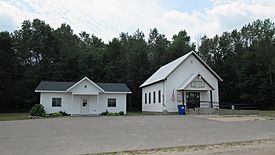
Aetna Town Hall
|
|

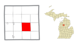
Location within Missaukee County and the state of Michigan
|
|
| Country | United States |
| State | Michigan |
| County | Missaukee |
| Established | 1871 |
| Area | |
| • Total | 35.885 sq mi (92.94 km2) |
| • Land | 35.877 sq mi (92.92 km2) |
| • Water | 0.008 sq mi (0.02 km2) |
| Elevation | 1,250 ft (381 m) |
| Population
(2020)
|
|
| • Total | 429 |
| • Density | 12.0/sq mi (4.6/km2) |
| Time zone | UTC-5 (Eastern (EST)) |
| • Summer (DST) | UTC-4 (EDT) |
| ZIP Codes | |
| Area code(s) | 231 |
| FIPS code | 26-00520 |
| GNIS feature ID | 1625806 |
Aetna Township is a small community located in Missaukee County, in the U.S. state of Michigan. It is a type of local government area known as a civil township. In 2020, about 429 people lived here.
Contents
Exploring Aetna Township's Communities
Aetna Township is home to a few smaller areas that have interesting histories. These are often called "unincorporated communities" because they don't have their own separate local government.
Dinca: A Historic Post Office
- Dinca is a small community within the township. It's located near the crossing of E. Lotan and S. 8 Mile Roads. A long time ago, from 1906 to 1914, Dinca even had its own rural post office.
Barger: Named for a Farmer
- Barger was another rural post office in the township. It was named after a farmer called Martin S. Barger. This post office was open for a few years, from 1902 to 1905.
Mynnings: A Lumber Settlement
- Mynnings was once a busy place with a post office and a settlement focused on the lumber industry. It was named after a lumberman, Christen F. Mynning. The Mynnings post office operated from 1900 to 1907.
Understanding Aetna Township's Geography
Aetna Township covers a total area of about 35.88 square miles (92.93 square kilometers). Most of this area is land, with only a tiny part, about 0.01 square miles (0.02 square kilometers), being water.
The township's land is shaped by nature, with streams and creeks flowing towards the east. These waterways eventually join the Muskegon River. One important creek, Butterfield Creek, flows through the southern part of the township.
Major Roads in Aetna Township
M-55 Highway: Connecting Communities
- M-55 is a state highway that forms the entire northern border of Aetna Township. This highway is important for travel in the area. If you head west on M-55, you'll reach Lake City, which is the main town and county seat of Missaukee County. If you go east, you'll arrive at Houghton Lake.
A Look at Aetna Township's Population
The number of people living in Aetna Township has changed over the years.
| Historical population | |||
|---|---|---|---|
| Census | Pop. | %± | |
| 1890 | 169 | — | |
| 1900 | 384 | 127.2% | |
| 1910 | 631 | 64.3% | |
| 1920 | 545 | −13.6% | |
| 1930 | 513 | −5.9% | |
| 1940 | 553 | 7.8% | |
| 1950 | 507 | −8.3% | |
| 1960 | 439 | −13.4% | |
| 1970 | 395 | −10.0% | |
| 1980 | 437 | 10.6% | |
| 1990 | 416 | −4.8% | |
| 2000 | 491 | 18.0% | |
| 2010 | 413 | −15.9% | |
| 2020 | 429 | 3.9% | |
| U.S. Decennial Census | |||
According to the 2020 census, there were 429 people living in Aetna Township. This means there were about 12 people per square mile.
In 2000, there were 491 people and 166 households. A household is a group of people living together in one home. Many of these households were families, including married couples.
The population included people of different ages. About 31% of the population was under 18 years old. The median age was 36 years, meaning half the people were younger than 36 and half were older.
See also
 In Spanish: Municipio de Aetna (condado de Missaukee) para niños


