Jennings, Michigan facts for kids
Quick facts for kids
Jennings, Michigan
|
|
|---|---|

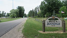
Welcome sign along S. La Chance Road
|
|

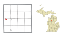
Location within Missaukee County and the state of Michigan
|
|
| Country | United States |
| State | Michigan |
| County | Missaukee |
| Townships | Lake and Caldwell |
| Established | 1885 |
| Area | |
| • Total | 0.76 sq mi (1.97 km2) |
| • Land | 0.76 sq mi (1.97 km2) |
| • Water | 0.00 sq mi (0.00 km2) |
| Elevation | 1,306 ft (398 m) |
| Population
(2020)
|
|
| • Total | 229 |
| • Density | 301.71/sq mi (116.54/km2) |
| Time zone | UTC-5 (Eastern (EST)) |
| • Summer (DST) | UTC-4 (EDT) |
| ZIP Code |
49651 (Lake City)
|
| Area code(s) | 231 |
| GNIS feature ID | 629259 |
| FIPS Code | 26-41720 |
Jennings is a small community in Missaukee County, in the state of Michigan, USA. It is known as an unincorporated community. This means it doesn't have its own local government like a city or town. It's also a census-designated place (CDP), which means the U.S. Census Bureau has officially defined its boundaries for counting people.
In 2020, about 229 people lived in Jennings. This number was a bit lower than in 2010. The community is mostly located in Lake Township, with a small part extending north into Caldwell Township.
A Look Back: Jennings' History
Jennings was established in 1885. It quickly became an important center for the lumber industry. This means many people worked there cutting down trees and processing wood.
The community was founded by two people named Austin and William Mitchell. They decided to name the place after William Jennings Bryan. He was a famous American politician.
Jennings had its own post office. It opened on March 8, 1883, and J. Frank Schryer was the first postmaster. The post office served the community for many years before closing on July 31, 1956.
The community was also connected by train. It was the end point for a special branch of the Grand Rapids and Indiana Railroad. This made it easier to transport lumber and other goods.
In 2010, Jennings was officially recognized as a "census-designated place." This means its borders and population figures are now officially recorded by the government.
Where is Jennings?
Jennings is located in the western part of Missaukee County, Michigan. To its east, you'll find Crooked Lake.
It's about 7 miles (11 km) by road west of Lake City. Lake City is important because it is the county seat of Missaukee County. This means it's where the main government offices for the county are located. Jennings is also about 10 miles (16 km) northeast of Cadillac.
According to the U.S. Census Bureau, the Jennings CDP covers an area of about 0.76 square miles (1.97 square kilometers). All of this area is land, with no water.
The official boundaries of the census-designated place include parts of both Caldwell Township and Lake Township. In 2010, all 264 residents and most of the land (0.67 square miles or 1.74 square kilometers) were within Lake Township. A smaller part of the land (0.09 square miles or 0.23 square kilometers) was in Caldwell Township to the north, but no residents lived in that part.
Who Lives in Jennings?
The population of Jennings has changed over the years. The U.S. Census Bureau counts how many people live in different areas every ten years.
Here's how the population has been:
- In 2010, there were 264 people living in Jennings.
- In 2020, the population was 229 people.
This shows a slight decrease in the number of residents between these two census counts.
See also
- In Spanish: Jennings (Míchigan) para niños
 | Janet Taylor Pickett |
 | Synthia Saint James |
 | Howardena Pindell |
 | Faith Ringgold |


