Kalkaska County, Michigan facts for kids
Quick facts for kids
Kalkaska County
|
|
|---|---|

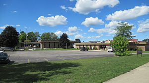
Kalkaska County Government Offices in Kalkaska
|
|

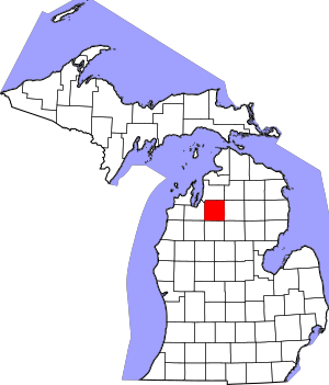
Location within the U.S. state of Michigan
|
|
 Michigan's location within the U.S. |
|
| Country | |
| State | |
| Founded | 1840 (established) 1871 (organized) |
| Seat | Kalkaska |
| Largest village | Kalkaska |
| Area | |
| • Total | 571 sq mi (1,480 km2) |
| • Land | 560 sq mi (1,500 km2) |
| • Water | 11 sq mi (30 km2) 1.9%% |
| Population
(2020)
|
|
| • Total | 17,939 |
| • Estimate
(2023)
|
18,490 |
| • Density | 31/sq mi (12/km2) |
| Time zone | UTC−5 (Eastern) |
| • Summer (DST) | UTC−4 (EDT) |
| Congressional district | 1st |
Kalkaska County is a county in the state of Michigan, USA. It's known for its beautiful natural areas. In 2020, about 17,939 people lived here. The main town and county seat is Kalkaska.
Kalkaska County is part of the larger Traverse City metropolitan area. Even though it's in the lower part of Michigan, it's considered part of "Northern Michigan."
Contents
History of Kalkaska County
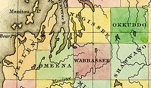
Kalkaska County was first created in 1840. Back then, it was called Wabassee County. It was separated from a much larger area known as Michilimackinac County. In 1843, its name was changed to Kalkaska.
For a while, in 1851, Kalkaska County was linked to Grand Traverse County for legal reasons. This meant Grand Traverse County handled its legal matters. The first person to settle in Kalkaska County was William Copeland from England. He bought land in 1855. Kalkaska County officially became its own organized county on January 27, 1871. After that, Crawford County was temporarily linked to Kalkaska County for legal purposes.
What Does "Kalkaska" Mean?
The name "Kalkaska" is a special word. It was made up by Henry Schoolcraft. He was a geographer and expert on Native American cultures in Michigan. Some people think the name comes from a Chippewa word. It might mean "flat" or "burned-over country."
Another idea is that Henry Schoolcraft created this new word himself. His family name was Calcraft. Some believe he added the "K" sounds to make it sound more like a Native American word.
Geography and Nature
Kalkaska County covers about 571 square miles. Most of this is land, but about 11 square miles are covered by water, like lakes and rivers.
The official state soil of Michigan is called Kalkaska sand. It got its name from this county! This sand was left behind by huge sheets of ice, called glaciers, during the Ice Age.
Kalkaska County is a watery place. It has over 80 lakes and about 275 miles of streams and rivers. A lot of the county is also marshland, which is wet, grassy land. The land here isn't flat. Its elevation goes from about 595 feet to 1,246 feet high. This makes it one of the more hilly counties in Michigan's Lower Peninsula.
A big part of the county is covered by the Pere Marquette State Forest. The glaciers that shaped the area also created a special natural environment. Much of the land is a "Grayling outwash plain." This is a wide, sandy area with small hills and different types of forests.
Lakes in Kalkaska County
- Torch Lake
- Starvation Lake
- Lake Skegemog
- Bear Lake
- Manistee Lake
- Grass Lake
- Rainbow Lake
- Blue Lake
- Cub Lake
- Twin Lake
- Little Twin Lake
- Pickerel Lake
- Squaw Lake
- Indian Lake
- Perch Lake
- Crawford Lake
- Lost Lake
- Johnson Rd Lake
- Log Lake
- Selkirk Lake
- Kettle Lake
- Lake Placid
- Sand Lake
- Twenty Eight Lakes
- East Lake
- Long Lake
- Lake Five
- Wheeler Lake
- Fife Lake
Rivers in Kalkaska County
- Boardman River
- Little Rapid River
- Manistee River
- Rapid River
- Torch River
Main Roads
 US 131 – This road goes through the western part of the county.
 M-66 – This road runs north and south through the middle of the county, passing through Kalkaska.
 M-72 – This road goes east and southeast through the middle of the county, also passing through Kalkaska.
Neighboring Counties
- Antrim County – to the north
- Otsego County – to the northeast
- Crawford County – to the east
- Roscommon County – to the southeast
- Missaukee County – to the south
- Wexford County – to the southwest
- Grand Traverse County – to the west
Communities in Kalkaska County
Village
- Kalkaska (This is the main town and county seat.)
Civil Townships
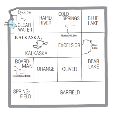
- Bear Lake Township
- Blue Lake Township
- Boardman Township
- Clearwater Township
- Coldsprings Township
- Excelsior Township
- Garfield Township
- Kalkaska Township
- Oliver Township
- Orange Township
- Rapid River Township
- Springfield Township
Former Townships
- Glade Township
- Wilson Township
Census-Designated Places
These are areas that the U.S. Census Bureau defines for gathering population data.
- Bear Lake
- Manistee Lake
- Rapid City
- South Boardman
Other Small Communities
- Barker Creek
- Crofton
- Darragh
- Houseman
- Leetsville
- Lodi
- Sigma
- Spencer
- Torch River
Population Over Time
| Historical population | |||
|---|---|---|---|
| Census | Pop. | %± | |
| 1870 | 424 | — | |
| 1880 | 2,937 | 592.7% | |
| 1890 | 5,160 | 75.7% | |
| 1900 | 7,133 | 38.2% | |
| 1910 | 8,097 | 13.5% | |
| 1920 | 5,577 | −31.1% | |
| 1930 | 3,799 | −31.9% | |
| 1940 | 5,159 | 35.8% | |
| 1950 | 4,597 | −10.9% | |
| 1960 | 4,382 | −4.7% | |
| 1970 | 5,272 | 20.3% | |
| 1980 | 10,952 | 107.7% | |
| 1990 | 13,497 | 23.2% | |
| 2000 | 16,571 | 22.8% | |
| 2010 | 17,153 | 3.5% | |
| 2020 | 17,939 | 4.6% | |
| 2023 (est.) | 18,490 | 7.8% | |
| US Decennial Census 1790-1960 1900-1990 1990-2000 2010-2018 |
|||
In 2010, there were about 16,571 people living in Kalkaska County. By 2020, the population had grown to 17,939 people. Most people in the county speak English as their first language.
Fun Events
The National Trout Festival is a yearly event held in April. It has been celebrated since 1936! This festival honors Kalkaska's history and love for fishing.
Education
The Northwest Educational Services helps students in Kalkaska County. It also serves students in nearby counties like Antrim and Grand Traverse. This organization provides special education, early learning programs, and career training for students.
Kalkaska County has several public school districts:
- Excelsior Township School District #1
- Forest Area Community Schools
- Kalkaska Public Schools
See also
 In Spanish: Condado de Kalkaska para niños
 | Delilah Pierce |
 | Gordon Parks |
 | Augusta Savage |
 | Charles Ethan Porter |


