Manistee County, Michigan facts for kids
Quick facts for kids
Manistee County
|
|
|---|---|
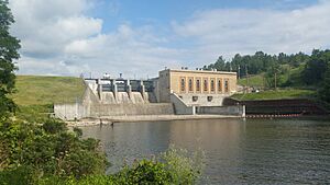
Tippy Dam on the Manistee River
|
|
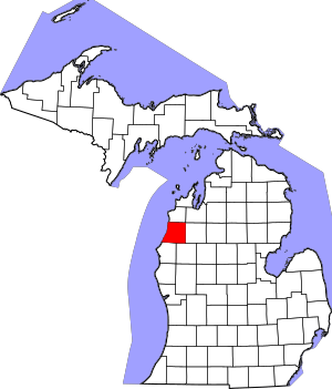
Location within the U.S. state of Michigan
|
|
 Michigan's location within the U.S. |
|
| Country | |
| State | |
| Founded | 1840 1855 (organized) |
| Seat | Manistee |
| Largest city | Manistee |
| Area | |
| • Total | 1,281 sq mi (3,320 km2) |
| • Land | 542 sq mi (1,400 km2) |
| • Water | 738 sq mi (1,910 km2) 58%% |
| Population
(2020)
|
|
| • Total | 25,032 |
| • Density | 46/sq mi (18/km2) |
| Time zone | UTC−5 (Eastern) |
| • Summer (DST) | UTC−4 (EDT) |
| Congressional district | 2nd |
Manistee County (/mænɪsti/ man-ISS-tee) is a county in the U.S. state of Michigan. It is located in the northern part of Michigan. In 2020, about 25,032 people lived there. The main city and county seat is Manistee.
The county gets its name from the Manistee River. Manistee County is known for its beautiful shoreline along Lake Michigan.
Contents
History of Manistee County
Manistee County was first created in 1840 from Michilimackinac County. At first, it wasn't fully set up as its own county. In 1851, it was connected to Grand Traverse County for legal matters. Finally, Manistee County became its own organized county on February 13, 1855.
What's in a Name?
The name "Manistee" comes from an Ojibwe word. This word was first used for the main river in the county. People are not completely sure what it means, but it might come from ministigweyaa, which means "river with islands at its mouth."
Historical Markers to See
There are thirteen special Michigan historical markers in Manistee County. These markers tell important stories about the area's past. Some of them include:
- Harriet Quimby Childhood Home (Harriet Quimby was the first American woman to get a pilot's license!)
- John J. Makinen Bottle House
- First Congregational Church, Manistee
- Great Fire of 1871
- Holy Trinity Episcopal Church
- Holy Trinity Episcopal Church Rectory
- Kaleva, Michigan
- Manistee City Library
- Manistee Fire Hall
- Our Saviour's Lutheran Church
- Ramsdell Theatre
- Trinity Lutheran Church [Arcadia]
- William Douglas House
Geography of Manistee County
Manistee County covers a total area of about 1,281 square miles. A large part of this area, about 738 square miles (58%), is water, mostly from Lake Michigan. The land area is about 542 square miles. Manistee County is part of a region called Northern Michigan.
Neighboring Counties
Manistee County shares borders with several other counties: By land
- Benzie County - to the north
- Grand Traverse County - to the northeast
- Wexford County - to the east
- Lake County - to the southeast
- Mason County - to the south
By water
- Manitowoc County, Wisconsin - to the southwest, across Lake Michigan
- Kewaunee County, Wisconsin - to the west, across Lake Michigan
Special Natural Areas
Manistee County has some beautiful protected natural areas:
- Manistee National Forest (a large forest with many outdoor activities)
- Nordhouse Dunes Wilderness (a special area with sand dunes and forests)
- Orchard Beach State Park (a park right on Lake Michigan)
Communities in Manistee County
Manistee County has one main city, several villages, and many smaller communities.
City
- Manistee (This is the county seat, where the county government is located.)
Villages
Census-Designated Places
These are areas that are like small towns but are not officially incorporated as cities or villages.
Other Small Communities
- Dublin
- Harlan
- Marilla
- Norwalk
- Pierport
- Pleasanton
- Portage Point
- Red Park
- Wick-A-Te-Wah
- Williamsport
Townships
Townships are smaller local government areas within the county.
- Arcadia Township
- Bear Lake Township
- Brown Township
- Cleon Township
- Dickson Township
- Filer Charter Township
- Manistee Township
- Maple Grove Township
- Marilla Township
- Norman Township
- Onekama Township
- Pleasanton Township
- Springdale Township
- Stronach Township
Population of Manistee County
The population of Manistee County has changed over the years. Here's how it has grown:
| Historical population | |||
|---|---|---|---|
| Census | Pop. | %± | |
| 1860 | 975 | — | |
| 1870 | 6,074 | 523.0% | |
| 1880 | 12,532 | 106.3% | |
| 1890 | 24,230 | 93.3% | |
| 1900 | 27,856 | 15.0% | |
| 1910 | 26,688 | −4.2% | |
| 1920 | 20,899 | −21.7% | |
| 1930 | 17,409 | −16.7% | |
| 1940 | 18,450 | 6.0% | |
| 1950 | 18,524 | 0.4% | |
| 1960 | 19,042 | 2.8% | |
| 1970 | 20,094 | 5.5% | |
| 1980 | 23,019 | 14.6% | |
| 1990 | 21,265 | −7.6% | |
| 2000 | 24,527 | 15.3% | |
| 2010 | 24,733 | 0.8% | |
| 2020 | 25,032 | 1.2% | |
| 2023 (est.) | 25,562 | 3.4% | |
| U.S. Decennial Census 1790-1960 1900-1990 1990-2000 2010-2018 |
|||
In 2020, the population of Manistee County was 25,032 people. The county has about 46 people per square mile of land.
Education in Manistee County
Manistee County has several school districts that serve its students:
- Bear Lake School District
- Benzie County Central School
- Kaleva Norman Dickson School District
- Manistee Area Schools
- Mason County Eastern District
- Mesick Consolidated Schools
- Onekama Consolidated Schools
Emergency Services
Manistee County has services to help people in emergencies.
Fire Departments
Many townships and the city of Manistee have their own fire departments. These departments help keep the community safe from fires.
- Arcadia Township Fire Department
- Bear Lake Township Fire Department
- City of Manistee Fire Department
- Cleon Township Fire Department
- Dickson Township Fire Department
- East Lake Township Fire Department
- Filer Township Fire Department
- Manistee Township Fire Department
- Maple Grove Township Fire Department
- Norman Township Fire Department
- Onekama Township Fire Department
- Stronach Township Fire Department
Transportation in Manistee County
Getting around Manistee County is easy with its airport and major roads.
Airport
The Manistee County-Blacker Airport is about 3 miles northeast of Manistee. You can fly from here directly to Chicago O'Hare International Airport.
Major Highways
Several important highways run through Manistee County, connecting it to other parts of Michigan.
 US 31 runs through Manistee and Bear Lake. It generally follows the coast of Lake Michigan but is a bit further inland than M-22.
 M-22 starts about 5 miles north of Manistee. It goes through Onekama and Arcadia. This highway runs very close to the Lake Michigan shoreline and is known as a Pure Michigan Byway because of its beautiful views.
 M-55 begins about 2 miles north of Manistee. It crosses the entire Lower Peninsula of Michigan, going through cities like Cadillac and Houghton Lake, all the way to Tawas City on the other side.
 M-115 is a diagonal highway that crosses the northeast part of the county. It connects to Benzie County to the north and Wexford County to the east.
Bicycle Routes
 USBR 35 is a bicycle route that comes from Mason County. It goes through Manistee, Onekama, and Arcadia before continuing north into Benzie County, often following M-22.
See also
 In Spanish: Condado de Manistee para niños
 | Laphonza Butler |
 | Daisy Bates |
 | Elizabeth Piper Ensley |


