Eastlake, Michigan facts for kids
Quick facts for kids
Eastlake, Michigan
|
|
|---|---|
|
Village
|
|

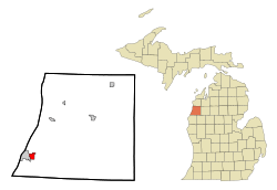
Location of Eastlake, Michigan
|
|
| Country | |
| State | |
| County | Manistee |
| Township | Manistee |
| Incorporated | 1912 |
| Area | |
| • Total | 1.46 sq mi (3.77 km2) |
| • Land | 1.20 sq mi (3.10 km2) |
| • Water | 0.26 sq mi (0.67 km2) |
| Population
(2020)
|
|
| • Total | 415 |
| • Density | 346.41/sq mi (133.74/km2) |
| Time zone | UTC-5 (Eastern (EST)) |
| • Summer (DST) | UTC-4 (EDT) |
| ZIP code |
49626
|
| Area code(s) | 231 |
| FIPS code | 26-24060 |
Eastlake is a small village located in the state of Michigan, in the United States. In 2020, about 415 people lived there.
Eastlake is part of Manistee County. It sits right across Manistee Lake from the city of Manistee. The village was officially started in 1912.
Contents
Where is Eastlake Located?
Eastlake is in the southwestern part of Manistee County. It's in the corner of Manistee Township. To the west, it shares a border with the city of Manistee. To the south, it's next to Stronach Township.
The Manistee River valley is to the north. Highway M-55 goes through the northeast part of the village. This highway can take you about 47 miles (76 km) east to Cadillac. It also goes about 1 mile (1.6 km) northwest to U.S. Route 31 in Parkdale. This road helps people get to the city of Manistee.
The village of Eastlake covers a total area of about 1.46 square miles (3.77 square kilometers). Most of this area, about 1.20 square miles (3.10 square kilometers), is land. The rest, about 0.26 square miles (0.67 square kilometers), is water.
What is Eastlake's Climate Like?
Eastlake has a type of weather called a humid continental climate. This means the area has big changes in temperature throughout the year.
Summers in Eastlake are usually warm to hot. They can also be quite humid. Winters are cold, and sometimes they can be very cold. This climate is often labeled as "Dfb" on climate maps.
How Many People Live in Eastlake?
Here's how the population of Eastlake has changed over the years:
| Historical population | |||
|---|---|---|---|
| Census | Pop. | %± | |
| 1890 | 1,856 | — | |
| 1920 | 675 | — | |
| 1930 | 392 | −41.9% | |
| 1940 | 412 | 5.1% | |
| 1950 | 376 | −8.7% | |
| 1960 | 436 | 16.0% | |
| 1970 | 512 | 17.4% | |
| 1980 | 514 | 0.4% | |
| 1990 | 473 | −8.0% | |
| 2000 | 441 | −6.8% | |
| 2010 | 512 | 16.1% | |
| 2020 | 415 | −18.9% | |
| U.S. Decennial Census | |||
In 2000, the average income for a household in Eastlake was about $131,750. For families, the average income was around $135,417. The average income per person was about $115,034. A small number of families and people, about 1.6% of families and 3.4% of the population, lived below the poverty line.
Eastlake's Population in 2010
According to the census from 2010, there were 512 people living in Eastlake. These people lived in 231 households, and 147 of those were families. The village had about 437.6 people per square mile (169.0 people per square kilometer). There were also 266 housing units.
Most of the people in the village were White (89.8%). There were also small percentages of African American (0.6%), Native American (3.1%), and Asian (0.2%) residents. Some people identified with two or more races (5.7%). About 2.9% of the population was Hispanic or Latino.
Out of the 231 households:
- 24.2% had children under 18 living with them.
- 44.6% were married couples living together.
- 12.6% had a female head of household with no husband.
- 6.5% had a male head of household with no wife.
- 36.4% were not families.
About 30.7% of all households had only one person living in them. And 14.3% had someone aged 65 or older living alone. The average household had 2.22 people. The average family had 2.65 people.
The average age of people in Eastlake in 2010 was 46.8 years old.
- 19.1% of residents were under 18.
- 5.2% were between 18 and 24.
- 23.1% were between 25 and 44.
- 30.6% were between 45 and 64.
- 22.1% were 65 years or older.
The village had slightly more females (52.1%) than males (47.9%).
See also

- In Spanish: Eastlake para niños
 | Ernest Everett Just |
 | Mary Jackson |
 | Emmett Chappelle |
 | Marie Maynard Daly |

