Onekama, Michigan facts for kids
Quick facts for kids
Onekama, Michigan
|
|
|---|---|
|
Village
|
|

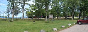
Onekama Village Park
|
|

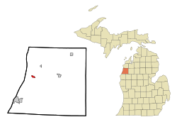
Location of Onekama, Michigan
|
|
| Country | |
| State | |
| County | Manistee |
| Township | Onekama |
| Area | |
| • Total | 0.59 sq mi (1.52 km2) |
| • Land | 0.59 sq mi (1.52 km2) |
| • Water | 0.00 sq mi (0.00 km2) |
| Elevation | 607 ft (185 m) |
| Population
(2020)
|
|
| • Total | 399 |
| • Density | 679.73/sq mi (262.46/km2) |
| Time zone | UTC-5 (Eastern (EST)) |
| • Summer (DST) | UTC-4 (EDT) |
| ZIP code |
49675
|
| Area code(s) | 231 |
| FIPS code | 26-60740 |
| GNIS feature ID | 1621108 |
Onekama is a small village in Manistee County, Michigan, in the United States. In 2020, about 399 people lived there. The village is on the northeast side of Portage Lake. It is surrounded by Onekama Township. The name "Onekama" comes from an old Anishinaabe word, Ona-ga-maa. This word means "singing water."
Contents
History of Onekama
The first settlement in this area was called Portage. It started in 1845 at the west end of Portage Lake. At that time, Portage Lake was land-locked, meaning it had no direct connection to Lake Michigan.
In 1871, people living around Portage Lake wanted to connect it to Lake Michigan. They dug a channel through a narrow strip of land. This channel lowered Portage Lake by about 12 to 14 feet. It made the lake level the same as Lake Michigan.
After this, the settlement of Portage moved. It moved to land that used to be underwater on the northeast shore of the lake. This new spot was near an older settlement called "Brookfield." The new town was named Onekama.
In 1880, the first public buildings were built in the new village. These included a gristmill and a sawmill. A gristmill grinds grain, and a sawmill cuts wood. In 1882, the first school was built. A large summer hotel, the Glen House, opened in 1883. It was known for its three mineral springs, which people thought had healing powers.
Onekama officially became a village in 1891. It included the Brookfield settlement. This made Onekama a long, narrow village. The main businesses were on the flat land that used to be part of the lake bottom. Homes were built on higher ground. In 1889, a train line, the Manistee and North-Eastern Railroad, reached the village.
Geography of Onekama
Onekama is in the western part of Manistee County. It is about 13 miles northeast of Manistee, which is the county seat. The village is also about 10 miles south of Arcadia. Lake Michigan is about 3 miles to the west. You can reach Lake Michigan through Portage Lake.
The village of Onekama covers about 0.59 square miles of land. There is no water area within the village limits. The M-22 highway runs right through the center of Onekama.
Population of Onekama
The population of Onekama has changed over the years. Here is a look at how many people have lived there during different census counts:
| Historical population | |||
|---|---|---|---|
| Census | Pop. | %± | |
| 1900 | 274 | — | |
| 1910 | 324 | 18.2% | |
| 1920 | 252 | −22.2% | |
| 1930 | 325 | 29.0% | |
| 1940 | 340 | 4.6% | |
| 1950 | 435 | 27.9% | |
| 1960 | 469 | 7.8% | |
| 1970 | 638 | 36.0% | |
| 1980 | 582 | −8.8% | |
| 1990 | 515 | −11.5% | |
| 2000 | 647 | 25.6% | |
| 2010 | 411 | −36.5% | |
| 2020 | 399 | −2.9% | |
| U.S. Decennial Census | |||
In 2010, there were 411 people living in Onekama. There were 205 households. About 17% of these households had children under 18. Many people living in Onekama were 65 years old or older. The average age in the village was 54.4 years.
Notable People from Onekama
- Rev. Dr. Francis J. Hall – He started the Chapel of St John-by-the-Lake in 1912.
- Paul P. Harris – He was the person who founded Rotary International, a global service organization.
See also
 In Spanish: Onekama para niños
 | Victor J. Glover |
 | Yvonne Cagle |
 | Jeanette Epps |
 | Bernard A. Harris Jr. |

