Newaygo County, Michigan facts for kids
Quick facts for kids
Newaygo County
|
||
|---|---|---|

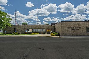
Newaygo County Courthouse
|
||
|
||

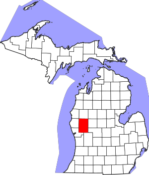
Location within the U.S. state of Michigan
|
||
 Michigan's location within the U.S. |
||
| Country | ||
| State | ||
| Founded | 1840 (established) 1851 (organized) |
|
| Seat | White Cloud | |
| Largest city | Fremont | |
| Area | ||
| • Total | 862 sq mi (2,230 km2) | |
| • Land | 813 sq mi (2,110 km2) | |
| • Water | 48 sq mi (120 km2) 5.6%% | |
| Population
(2020)
|
||
| • Total | 49,978 | |
| • Density | 60/sq mi (22/km2) | |
| Time zone | UTC−5 (Eastern) | |
| • Summer (DST) | UTC−4 (EDT) | |
| Congressional district | 2nd | |
Newaygo County is a county in the state of Michigan. In 2020, about 49,978 people lived there. The main town, or county seat, is White Cloud.
The county was created in 1840 and officially started in 1851. Its name might come from an Ojibwe leader who signed an important agreement in 1819. Another idea is that it comes from an Algonquian word meaning "much water."
Contents
Exploring Newaygo County's Geography
Newaygo County covers about 862 square miles. Most of this area, 813 square miles, is land. The rest, about 48 square miles, is covered by water. This means about 5.6% of the county is water. Newaygo County is part of an area called West Michigan.
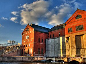
The county is known for its many lakes and rivers. It has over 230 natural lakes! All the rivers and streams together stretch for more than 350 miles. Three big dams were built here in the early 1900s. These are the Croton, Hardy, and Newaygo dams. The Hardy Dam is the largest earthen dam east of the Mississippi River. More than half of Newaygo County is part of the Manistee National Forest.
Rivers Flowing Through Newaygo County
Main Roads in Newaygo County
 M-20 This road goes east to west through the middle of the county. It passes through Hesperia, Aetna, and White Cloud.
 M-37 This road goes north to south through the county's center. You can find Bitely, Brohman, White Cloud, Newaygo, Grant, and Ashland along this road.
 M-82 This road runs east to west in the southern part of the county. It goes through Newaygo.
- M-120 This road runs along the western edge of the county. It ends in Hesperia.
County Roads
 B-96
B-96
Neighboring Counties
- Mason County – to the northwest
- Lake County – to the north
- Osceola County - to the northeast
- Mecosta County – to the east
- Montcalm County – to the southeast
- Kent County – to the south
- Muskegon County – to the southwest
- Oceana County – to the west
Protected Natural Areas
- Manistee National Forest (part of it is in Newaygo County)
People and Population of Newaygo County
| Historical population | |||
|---|---|---|---|
| Census | Pop. | %± | |
| 1850 | 510 | — | |
| 1860 | 2,760 | 441.2% | |
| 1870 | 7,294 | 164.3% | |
| 1880 | 14,688 | 101.4% | |
| 1890 | 20,476 | 39.4% | |
| 1900 | 17,673 | −13.7% | |
| 1910 | 19,220 | 8.8% | |
| 1920 | 17,378 | −9.6% | |
| 1930 | 17,029 | −2.0% | |
| 1940 | 19,286 | 13.3% | |
| 1950 | 21,567 | 11.8% | |
| 1960 | 24,160 | 12.0% | |
| 1970 | 27,992 | 15.9% | |
| 1980 | 34,917 | 24.7% | |
| 1990 | 38,202 | 9.4% | |
| 2000 | 47,874 | 25.3% | |
| 2010 | 48,460 | 1.2% | |
| 2020 | 49,978 | 3.1% | |
| 2023 (est.) | 51,108 | 5.5% | |
| US Decennial Census 1790-1960 1900-1990 1990-2000 2010-2018 |
|||
In 2000, there were 47,874 people living in Newaygo County. There were about 17,599 households, which are groups of people living together. Many of these were families. The population density was about 57 people per square mile.
About 29% of the people in the county were under 18 years old. The average age was 36 years old. Most people in the county spoke English.
Religions in Newaygo County
Many different religious groups have churches and members in Newaygo County. Some of the larger groups include:
- The Catholic church
- The Christian Reformed Church in North America
- The United Methodist Church
- The Reformed Church in America
- The Church of Jesus Christ of Latter-day Saints
- The Seventh-day Adventist Church
Newaygo County's Economy and Jobs
Tourism is the most important part of Newaygo County's economy. Many people visit the area for its natural beauty. After tourism, farming and small factories are also important.
Gerber Products Company, a big company that makes baby food, is the largest employer in the county. They have about 1,300 employees.
Newaygo County is also a popular place for people to have summer cottages. Fishermen enjoy catching steelhead in the spring and salmon in the fall in the county's rivers. Many outdoor activities like camping, hunting, cross-country skiing, bicycling, and bird watching are popular in the Manistee National Forest.
Companies in Newaygo County
- County of Newaygo - White Cloud
- Dura Automotive Systems - Fremont
- Gerber Memorial Health Services - Fremont
- Gerber Products Company - Fremont
- Magna Donnelly - Newaygo
- North American Refractories - White Cloud
- Valspar Corporation - Fremont
- Wilbur Ellis - Grant
- Newaygo Brewing - Newaygo
Fun Festivals and Events
- Memorial Weekend Arts & Crafts Festival - Newaygo
- River Country Home & Garden Show - Newaygo Middle School
- Newaygo County Kids' Day - Downtown Newaygo
- Trail Town Celebration - Celebrating White Clouds Trails & Waterways
- City-Wide Yard Sales - Grant
- Harvest Celebration - Grant
- Harvest Festival - Fremont
- Logging Festival - Mid-Michigan Lumberjack Competition in Newaygo
- Bitely Homecoming - Bitely
- National Baby Food Festival - Fremont
- Pow Wow - White Cloud
- Santa Parade - Fremont
- West Michigan's Longest Yard Sale - Grant, Newaygo, White Cloud, Bitely
- Winterfest - Newaygo
- Christmas in Newaygo
- Christmas in Grant
- Christmas in White Cloud
Historic Places to Visit
Newaygo County has 16 places that are recognized as historically important by the state. Two of these places are even listed on the National Register of Historic Places.
- Big Prairie Grange Hall No. 935 - Goodwell Twp
- Birch Grove School - Lincoln Twp
- Croton Congregational Church - Croton Twp
- Croton Hydroelectric Plant - Croton Twp
- Ensley Windmill Tower
- First Christian Reformed Church (Demolished) - Fremont
- Gerber, Cornelius, Cottage - Sheridan Charter Twp
- Grant Depot and Water Tower - Grant
- Hardy Hydroelectric Plant - Big Prairie - Twp
- Lilley District No. 5 School - Lilley Twp
- Oak Grove District No. 3 Schoolhouse - Croton Twp
- Penoyer's Sawmill - Newaygo
- Saint Mark's Episcopal Church - Newaygo
- Weaver, Daniel, House - Denver Twp
- White Cloud Village Hall (Demolished) - White Cloud
- Woods, John F., Residence - Newaygo
Towns and Communities
Cities in Newaygo County
- Fremont
- Grant
- Newaygo
- White Cloud (This is the county seat, where the main government offices are.)
Villages
- Hesperia (partially in this county)
Smaller Communities (Unincorporated)
- Aetna
- Big Prairie
- Bitely
- Brohman
- Brunswick (partially)
- Croton
- Ensley Center
- Lilley
- Riverview
- Woodland Park
- Woodville
- Wooster
Charter Township
- Sheridan Charter Township
Civil Townships
- Ashland Township
- Barton Township
- Beaver Township
- Big Prairie Township
- Bridgeton Township
- Brooks Township
- Croton Township
- Dayton Township
- Denver Township
- Ensley Township
- Everett Township
- Garfield Township
- Goodwell Township
- Grant Township
- Home Township
- Lilley Township
- Lincoln Township
- Merrill Township
- Monroe Township
- Norwich Township
- Sherman Township
- Troy Township
- Wilcox Township
Education in Newaygo County
The Newaygo County Regional Educational Service Agency, located in Fremont, helps the school districts in the county. This agency provides special education services and programs for students to learn job skills.
Newaygo County has several public school districts:
- Big Jackson School District
- Fremont Public School District
- Grant Public School District
- Hesperia Community Schools
- Newaygo Public School District
- White Cloud Public Schools
There are also private schools in Newaygo County:
- Cornerstone Christian Academy
- Fremont Christian School
- Grant Christian School
See also
 In Spanish: Condado de Newaygo para niños
 | Anna J. Cooper |
 | Mary McLeod Bethune |
 | Lillie Mae Bradford |


