
Oceana County, Michigan facts for kids
Quick facts for kids
Oceana County
|
||
|---|---|---|

Oceana County Courthouse
|
||
|
||

Location within the U.S. state of Michigan
|
||
 Michigan's location within the U.S. |
||
| Country | ||
| State | ||
| Founded | 1840 (created) 1855 (organized) |
|
| Seat | Hart | |
| Largest city | Hart | |
| Area | ||
| • Total | 1,306 sq mi (3,380 km2) | |
| • Land | 512 sq mi (1,330 km2) | |
| • Water | 794 sq mi (2,060 km2) 61%% | |
| Population
(2020)
|
||
| • Total | 26,659 | |
| • Estimate
(2023)
|
26,981 |
|
| • Density | 20.413/sq mi (7.881/km2) | |
| Time zone | UTC−5 (Eastern) | |
| • Summer (DST) | UTC−4 (EDT) | |
| Congressional district | 2nd | |

Oceana County is a county in the state of Michigan. In 2020, about 26,659 people lived there. The main town and county seat is Hart.
Oceana County is in the West Michigan area of Michigan's Lower Peninsula. It has a long shoreline along Lake Michigan. This helps with farming and tourism. The county is also known as the "Asparagus Capital of the World." It hosts the National Asparagus Festival in Hart.

Contents
History
Before European settlers arrived, the Ojibwe people lived in the area that is now Oceana County. Early settlers came because they could use the White River to travel. This river flows into Lake Michigan.
The state of Michigan officially created Oceana County on April 1, 1840. It became an organized county in 1855. No one is completely sure how the county got its name. It might be named after Lake Michigan, which is like a huge freshwater "ocean." Another idea is that it was named after a book called Oceana. This book was written by an English author named James Harrington in 1656.
In the 1850s, the U.S. government moved about 1,400 Odawa (another Native American group) to this area from Ionia County, Michigan.
The county's first main business was the lumber trade. Logs were floated down the rivers. Later, farming became very important. Today, Oceana County is famous for growing a lot of asparagus. It's even called the "Asparagus Capital of the World." Every year, there's an Asparagus Festival with a parade and an Asparagus Queen.
Geography
Oceana County covers a total area of about 1,306 square miles (3,380 km²). About 512 square miles (1,326 km²) of this is land, and 794 square miles (2,056 km²) is water. This means a big part of the county (61%) is water. The county is part of the West Michigan region. Its western border is along Lake Michigan.
Neighboring Counties
Oceana County shares borders with other counties.
By land:
- Mason County – to the north
- Lake County – to the northeast
- Newaygo County – to the east
- Muskegon County – to the south
By water:
- Ozaukee County, Wisconsin – to the southwest
- Sheboygan County, Wisconsin – to the west
Protected Areas
Part of the Manistee National Forest is located in Oceana County. This is a large area of protected land.
Main Roads
 US 31 is a major highway that runs north and south through the western part of Oceana County. It passes through towns like Rothbury, New Era, Shelby, Mears, Hart, and Pentwater.
Bus. US 31 is a smaller road that goes through downtown Hart. M-20 is a road that goes east and west in the southern part of the county. It starts near US 31 and goes towards Hesperia.
- M-120 is a road that goes north and south. It connects to M-20 at Hesperia.
County Roads
 B-15 is a special county road that runs along the Lake Michigan shoreline. It goes through places like Stony Lake and the Silver Lake area.
People and Population
Oceana County is a rural area. In 2020, the population was 26,659. The county has welcomed many people from Hispanic or Latino backgrounds. Many of them work in farming. In 2010, about 13.7% of the people in Oceana County were Hispanic or Latino.
Religion
Many different Christian groups have churches in Oceana County. The county is part of the Roman Catholic Diocese of Grand Rapids and the Episcopal Diocese of Western Michigan. There is also a meetinghouse for the Church of Jesus Christ of Latter-day Saints.
Tourism
Tourism is a big part of Oceana County. The Electric Forest Festival is a large music festival held every year in Rothbury, Michigan. It started in 2008.
Camping is a very popular activity in the summer. Places along the lakeshore like Silver Lake, Pentwater, and Stony Lake are popular spots for visitors.
Education
The West Shore Educational Service District helps schools in Oceana County, as well as in Mason and Lake counties. This district offers special education and career programs for students.
Here are some of the public school districts in Oceana County:
- Hart Public School District
- Pentwater Public School District
- Shelby Public Schools
- Walkerville Public Schools
There are also private schools in Oceana County:
- New Era Christian School
- Oceana Christian School (a Baptist school)
Communities
City
- Hart (This is the main town and where the county government is located.)
Villages
Census-Designated Place
- Mears (This is a community that the Census Bureau defines for statistics.)
Other Communities
- Bird
- Collinsville
- Corbin's Mill
- Cranston
- Crystal Valley
- Elbridge
- Elmwood
- Elwood
- Ferry
- Flower Creek
- Forest City
- Gale
- Silver Lake
- Stony Lake
Townships
Oceana County is divided into several townships, which are local government areas:
- Benona Township
- Claybanks Township
- Colfax Township
- Crystal Township
- Elbridge Township
- Ferry Township
- Golden Township
- Grant Township
- Greenwood Township
- Hart Township
- Leavitt Township
- Newfield Township
- Otto Township
- Pentwater Township
- Shelby Township
- Weare Township
Images for kids
-
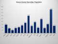
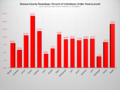
Population chart for Oceana County townships.
-
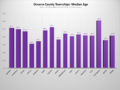
Median age chart for Oceana County townships.
-
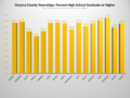
High school graduates chart for Oceana County townships.
-

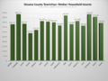
Total housing units chart for Oceana County townships.
-
Median household income chart for Oceana County townships.
-
Individuals under poverty level chart for Oceana County townships.


See also
 In Spanish: Condado de Oceana para niños
