Hesperia, Michigan facts for kids
Quick facts for kids
Hesperia, Michigan
|
|
|---|---|
|
Village
|
|

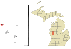
Location of Hesperia, Michigan
|
|
| Country | United States |
| State | Michigan |
| Counties | Oceana, Newaygo |
| Area | |
| • Total | 0.86 sq mi (2.22 km2) |
| • Land | 0.82 sq mi (2.12 km2) |
| • Water | 0.04 sq mi (0.10 km2) |
| Elevation | 745 ft (227 m) |
| Population
(2020)
|
|
| • Total | 1,034 |
| • Density | 1,264.06/sq mi (487.99/km2) |
| Time zone | UTC-5 (Eastern (EST)) |
| • Summer (DST) | UTC-4 (EDT) |
| ZIP code |
49421
|
| Area code(s) | 231 |
| FIPS code | 26-37860 |
| GNIS feature ID | 1620176 |
| Website | Hesperia |
Hesperia is a small village located in the state of Michigan, in the United States. It's unique because it sits across two different counties: Newaygo and Oceana. In fact, it's the only village found in Newaygo County. About half of Hesperia is in Newfield Township (Oceana County), and the other half is in Denver Township (Newaygo County).
In 2010, the village had a population of 954 people. By 2020, the population had grown slightly to 1,034 residents.
Contents
Geography of Hesperia
Hesperia covers a total area of about 0.86 square miles (2.22 square kilometers). Most of this area is land, with a small part being water.
Main Roads in Hesperia
Two important state highways pass through or end in Hesperia:
- M-20 travels from east to west right through the village.
- M-120 runs along the border between Newaygo and Oceana counties. It ends in Hesperia when it meets M-20.
Hesperia's Climate
Hesperia experiences a type of weather called a humid continental climate. This means the village has big changes in temperature throughout the year. Summers are usually warm to hot, and can sometimes feel humid. Winters are cold, and can even be very cold.
Population and People
The population of Hesperia has changed over the years, as shown by the U.S. Census:
| Historical population | |||
|---|---|---|---|
| Census | Pop. | %± | |
| 1880 | 147 | — | |
| 1890 | 506 | 244.2% | |
| 1900 | 474 | −6.3% | |
| 1910 | 462 | −2.5% | |
| 1920 | 439 | −5.0% | |
| 1930 | 467 | 6.4% | |
| 1940 | 535 | 14.6% | |
| 1950 | 760 | 42.1% | |
| 1960 | 822 | 8.2% | |
| 1970 | 877 | 6.7% | |
| 1980 | 876 | −0.1% | |
| 1990 | 846 | −3.4% | |
| 2000 | 954 | 12.8% | |
| 2010 | 954 | 0.0% | |
| 2020 | 1,034 | 8.4% | |
| U.S. Decennial Census | |||
Hesperia in 2010
According to the 2010 United States Census, Hesperia had 954 residents, which was the same number as in 2000. There were 382 households and 231 families living in the village.
The population density was about 1,211 people per square mile (or 467 people per square kilometer). There were 431 housing units in total.
Most of the people in Hesperia were White (88.5%). About 8.1% of the population was Hispanic or Latino. A small number of residents were Native American (1.0%) or from two or more races (2.3%).
Of the households, 34% had children under 18 living with them. The average household had 2.45 people, and the average family had 3.14 people.
The age breakdown of the population was:
- 27% were under 18 years old.
- 10.7% were between 18 and 24 years old.
- 21.3% were between 25 and 44 years old.
- 24.8% were between 45 and 64 years old.
- 16.1% were 65 years or older.
The average age of people in Hesperia was 36 years. For every 100 females, there were about 78.7 males.
See also
 In Spanish: Hesperia (Míchigan) para niños
 | William L. Dawson |
 | W. E. B. Du Bois |
 | Harry Belafonte |

