Grant, Michigan facts for kids
Quick facts for kids
Grant, Michigan
|
|
|---|---|

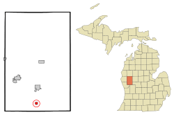
Location of Grant within Newaygo County, Michigan
|
|
| Country | United States |
| State | Michigan |
| County | Newaygo |
| Village incorporation | 1893 |
| City incorporation | 1969 |
| Area | |
| • Total | 0.69 sq mi (1.77 km2) |
| • Land | 0.67 sq mi (1.72 km2) |
| • Water | 0.02 sq mi (0.05 km2) |
| Elevation | 833 ft (255 m) |
| Population
(2020)
|
|
| • Total | 952 |
| • Density | 1,431.58/sq mi (552.51/km2) |
| Time zone | UTC-5 (EST) |
| • Summer (DST) | UTC-4 (EDT) |
| ZIP code |
49327
|
| Area code(s) | 231 |
| FIPS code | 26-34360 |
| GNIS feature ID | 0627144 |
Grant is a small city in Newaygo County, which is part of the U.S. state of Michigan. In 2020, about 952 people lived there. The city is close to Grant Township and Ashland Township. It is also part of a larger area called the Grand Rapids-Muskegon-Holland, Michigan combined statistical area.
Contents
History of Grant
The story of Grant began in 1882. That year, a man named Andrew J. Squier built the very first saw mill here. A saw mill is a place where logs are cut into lumber. Soon after, a train station was built for the Chicago and Western Michigan Railroad.
Squier decided to name the station "Grant Station." He named it after Ulysses S. Grant, who was a U.S. President and a famous general during the American Civil War. Because of its central spot in the area, the community was also known as Grant Center.
A post office opened in Grant Station on May 14, 1892. In 1893, Grant Center officially became a village, and its name was shortened to Grant. The post office name also changed to Grant in 1899.
During the time when lumber was a very big business, the sawmills in Grant were very busy. They shipped out a million feet of lumber every year! Later, in 1969, the village of Grant became a city.
Geography
Grant is a small city in terms of its size. According to the United States Census Bureau, the city covers about 0.67 square miles (1.72 square kilometers) in total. Most of this area, about 0.65 square miles (1.68 square kilometers), is land. A very small part, about 0.02 square miles (0.05 square kilometers), is water.
Population Information
| Historical population | |||
|---|---|---|---|
| Census | Pop. | %± | |
| 1880 | 90 | — | |
| 1900 | 214 | — | |
| 1910 | 428 | 100.0% | |
| 1920 | 473 | 10.5% | |
| 1930 | 483 | 2.1% | |
| 1940 | 552 | 14.3% | |
| 1950 | 646 | 17.0% | |
| 1960 | 732 | 13.3% | |
| 1970 | 772 | 5.5% | |
| 1980 | 683 | −11.5% | |
| 1990 | 764 | 11.9% | |
| 2000 | 881 | 15.3% | |
| 2010 | 894 | 1.5% | |
| 2020 | 952 | 6.5% | |
| U.S. Decennial Census | |||
Grant's Population in 2010
In 2010, there were 894 people living in Grant. These people lived in 361 different homes, and 229 of those homes were families.
Most of the people in Grant were White, making up about 93.8% of the population. A small number of people were African American, Native American, or Asian. About 13.3% of the people in Grant were Hispanic or Latino.
Looking at the homes, about 37.7% had children under 18 living there. About 41% of homes had married couples. Some homes had a female head of the house without a husband, and a few had a male head of the house without a wife. About 31.9% of all homes had just one person living there. Also, 18.5% of homes had someone living alone who was 65 years old or older.
The average age of people in Grant was about 31.9 years old. Almost 30% of residents were under 18. About 9% were between 18 and 24. People aged 25 to 44 made up about 25% of the population. About 21% were between 45 and 64, and 15.7% were 65 or older. In terms of gender, 46.2% of the population was male, and 53.8% was female.
Places to See
Main Roads
 M-37
M-37
See also
 In Spanish: Grant (Míchigan) para niños
 | James B. Knighten |
 | Azellia White |
 | Willa Brown |

