
Tittabawassee River facts for kids
Quick facts for kids Tittabawassee River |
|
|---|---|

Saginaw River watershed
|
|
| Physical characteristics | |
| Main source | Edwards Township, Ogemaw County, Michigan 44°05′27″N 84°18′49″W / 44.09085°N 84.31361°W |
| River mouth | Saginaw River, Michigan 43°23′12″N 83°57′58″W / 43.38669°N 83.96608°W |
| Length | 72 mi (116 km) |
| Basin features | |
| Basin size | 2,471 sq mi (6,400 km2) |

The Tittabawassee River is a river in the Lower Peninsula of Michigan, a state in the United States. It flows mostly towards the southeast.
This river starts at Secord Lake in Clement Township. This is where its two main parts, the East Branch and the Middle Branch, join together. From there, the Tittabawassee River flows through Gladwin, Midland, and Saginaw counties.
The Tittabawassee River is a big tributary of the Saginaw River. A tributary is a smaller river or stream that flows into a larger river. The Tittabawassee River joins the Saginaw River in Saginaw. Other rivers that flow into the Tittabawassee include the Chippewa, Pine, Molasses, Sugar, and Tobacco rivers.
Contents
Where does the Tittabawassee River flow?
The Tittabawassee River passes by or near several important towns. These include Saginaw, Midland, and Sanford.
At a place called Edenville, a dam was built across the river. This dam, called the Edenville Dam, created a lake known as Wixom Lake. Another dam was built in Sanford, which created Sanford Lake. These dams were used to make electricity. However, both dams broke in May 2020, causing a lot of flooding.
In Saginaw County, the river flows through Tittabawassee Township. This township is named after the river. The small community of Freeland is also located in this township.
The main part of the Tittabawassee River is about 72.4 miles (116.5 kilometers) long. It drains water from a large area of about 2,471 square miles (6,400 square kilometers).
What happened during the 2020 floods?
_01.jpg)
On May 19, 2020, the Edenville Dam broke. After that, the Sanford Dam, which was downstream, was also overflowed by the rising water. A protective wall (dike) also broke near Poseyville. These events caused very serious flooding in Midland County.
About 10,000 people had to leave their homes for safety. This included people from a seniors' home and some hospital patients. Two emergency shelters had to move because of the floodwaters and power outages.
Water from the flood entered the Dow Chemical plant, which is a big factory. This made the factory shut down. The floodwater also mixed with water in the factory's special ponds, which raised concerns about pollution. The next day, experts thought the water levels would reach 38 feet, which was four feet higher than a big flood in 1986.
To help with the emergency, units from the National Guard and a team from the FEMA were called in. FEMA is a government agency that helps people during disasters.
Images for kids
-
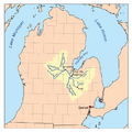
Map showing the Saginaw River watershed, which includes the Tittabawassee River.
See also
 In Spanish: Río Tittabawassee para niños
