
Chippewa River (Michigan) facts for kids
Quick facts for kids Chippewa River |
|
|---|---|

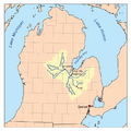
Map of the Saginaw River watershed showing the Chippewa River as one of its major tributaries
|
|
| Country | United States |
| State | Michigan |
| Counties | Mecosta, Isabella, Midland |
| Municipalities | Barryton, Mount Pleasant, Midland |
| Physical characteristics | |
| Main source | Confluence of North Branch Chippewa River and West Branch Chippewa River Barryton |
| River mouth | Tittabawassee River Midland 600 ft (180 m) |
| Length | 92 mi (148 km) |
| Basin features | |
| River system | Saginaw River |
| Tributaries |
|
The Chippewa River is a stream in Michigan, United States. It flows for about 92 miles (148 km) through the middle part of Michigan. The Chippewa River flows into the Tittabawassee River. This means it is part of the larger Saginaw River water system. The river gets its name from the Chippewa people. The Saginaw Chippewa Tribal Nation lives in Isabella County, near the river.
Contents
Where Does the Chippewa River Start and Flow?
The main part of the Chippewa River starts in northeast Mecosta County. This is in the village of Barryton. Here, two smaller rivers, the North Branch and West Branch, join together. They are held back by a dam.
North Branch and West Branch Origins
The North Branch Chippewa River starts from Big Cranberry Lake. This lake is in Clare County. The West Branch Chippewa River begins from Tubbs Lake. Tubbs Lake is part of many lakes formed by the Winchester Dam. This dam was built in 1954. It created a large flooded area called the Martiny Lake Flooding.
Journey Through Mount Pleasant
Another North Branch Chippewa River flows south into the main Chippewa River. This happens a few miles west of Mount Pleasant. The river then flows right through Mount Pleasant. It is a main feature of four parks in the city: Millpond Park, Nelson Park, Chipp-A-Water, and Island Park. In Island Park, the river goes all the way around the park. This makes a natural island in the middle of the city. Three other parks in Isabella County also use the river for fun activities. These are Meridian Park, Deerfield Nature Park, and Majeski Landing.
Reaching the Tittabawassee River
The river continues flowing east into Midland County. Here, another river called the Pine River joins it. This happens near the Chippewa Nature Center. Finally, the Chippewa River meets the Tittabawassee River in downtown Midland. They meet right under a special bridge called The Tridge.

River Activities and Wildlife
The Chippewa River flows at a speed of about 254 cubic feet per second (7.19 cubic meters per second) near Mount Pleasant. People in the area know it as a great spot for bass fishing. You can also find many chubs and redhorses here.
There are two places where you can rent canoes or kayaks: Chippewa River Outfitters and Buckley's Mountainside Canoe Livery. They offer trips that can last a few hours, all day, or even overnight camping trips. The river also flows through a gravel pit called Hubsher Gravel Pit. The Chippewa River is an important source of water for the city of Mount Pleasant.
What Are Tributaries?
A tributary is a smaller stream or river that flows into a larger river. The Chippewa River has many tributaries that add water to it. Some of the main ones include the Pine River and the Coldwater River. These smaller rivers and streams help make up the larger Chippewa River system.
Images for kids
-
Map of the Saginaw River watershed showing the Chippewa River as one of its major tributaries
