Pine River (Michigan) facts for kids
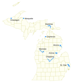
Did you know that many rivers in the U.S. state of Michigan share the same name? The name Pine River is very popular, and it refers to several different waterways across the state. This article will help you learn about some of these rivers and where they flow.
Main Pine Rivers in Michigan
Michigan is home to many rivers called Pine River. Each one has its own unique journey through the landscape.
Pine River (Alcona County)
This Pine River starts in Alcona County. It forms when two smaller streams, the East and West Branches, join together. A bit further south, the South Branch also adds its water. This river then flows into Iosco County and eventually empties into Van Etten Lake, which is near the town of Oscoda.
- The main branch forms at 44°29′38″N 83°23′16″W / 44.49389°N 83.38778°W.
- It flows into Van Etten Lake at 44°29′38″N 83°23′16″W / 44.49389°N 83.38778°W.
Pine River (Arenac County)
You can find another Pine River in Arenac County. This river begins when its North and Middle Branches meet northeast of Standish. It then flows into the Saginaw Bay, which is part of Lake Huron. The South Branch Pine River also joins this main stream along its path.
- The main branch flows into Saginaw Bay at 43°58′32″N 83°51′16″W / 43.97556°N 83.85444°W.
- The South Branch joins at 43°59′08″N 83°53′17″W / 43.98556°N 83.88806°W.
Pine River (Charlevoix County)
This is a shorter river located in Charlevoix. It plays an important role by connecting two larger lakes: Lake Charlevoix and Lake Michigan. It flows through Round Lake as part of its journey.
Pine River (Chippewa River Tributary)
This Pine River starts from Pine Lake in eastern Mecosta County. It travels mostly east and south through Isabella County, then south along the edge of Montcalm County. After that, it turns east and north through Gratiot County and Midland County. Finally, it empties into the Chippewa River near Midland, not far from where the Chippewa River joins the Tittabawassee River.
- It empties into the Chippewa River at 43°36′06″N 84°17′33″W / 43.60167°N 84.29250°W.
- The South Branch Pine River joins at 43°30′37″N 85°00′02″W / 43.51028°N 85.00056°W.
- The North Branch Pine River joins at 43°26′03″N 84°50′18″W / 43.43417°N 84.83833°W.
- Sometimes, a stream called Miller Creek is also known as Pine River or the West Branch Pine River.
Pine River (Mackinac County)
This river begins its journey in Chippewa County. It then flows south through Mackinac County and empties into the St. Martin Bay, which is part of Lake Huron. The North Pine River, also known as the North Branch Pine River, joins this main stream.
- It flows into St. Martin Bay at 46°03′09″N 84°39′22″W / 46.05250°N 84.65611°W.
- The North Pine River joins at 46°12′20″N 84°36′17″W / 46.20556°N 84.60472°W.
- Hemlock Creek is another stream sometimes called Pine River.
Pine River (Manistee River Tributary)
This Pine River is also known as the South Branch Manistee River. It starts in southeastern Wexford County. It flows southwest across northwestern Osceola County, then west and north through a small part of Lake County, and back into southwestern Wexford County. It eventually empties into the Tippy Dam Pond, which is on the Manistee River. The main part of this river forms where the East Branch Pine River and the North Branch Pine River (also called the Little Pine River) meet.
- It empties into Tippy Dam Pond at 44°13′37″N 85°54′27″W / 44.22694°N 85.90750°W.
- The main stream forms at 44°06′02″N 85°31′40″W / 44.10056°N 85.52778°W.
- Spaulding Creek is another tributary that is sometimes known as the Little Pine River.
Pine River (Marquette County)
This is a very short river located in Marquette County. It drains Pine Lake directly into Lake Superior. You can find it north of the Huron Mountains.
- It drains into Lake Superior at 46°53′27″N 87°52′13″W / 46.89083°N 87.87028°W.
Pine River (St. Clair River)
This Pine River begins in Brockway Township in St. Clair County. It flows southeast and eventually empties into the St. Clair River on the south side of St. Clair. The South Branch Pine River joins the main stream along its journey.
- It empties into the St. Clair River at 42°49′13″N 82°29′08″W / 42.82028°N 82.48556°W.
- The South Branch Pine River joins at 42°58′11″N 82°37′10″W / 42.96972°N 82.61944°W.
- A stream called Quakenbush Drain is also sometimes known as Pine River.
Other Streams: Pine Creek
Besides the rivers named Pine River, there are also at least seventeen streams in Michigan known as Pine Creek. Sometimes, people might even call these "Pine River" by mistake. Here are a couple of examples:
Pine Creek (Maple River Tributary)
This Pine Creek starts south of Alma in Newark Township, Gratiot County. It flows mostly south into Clinton County. It then empties into the Maple River near Maple Rapids.
- It empties into the Maple River at 43°6′33″N 84°41′35″W / 43.10917°N 84.69306°W.
Pine Creek (Ontonagon County)
This is a stream in Ontonagon County that flows north. It empties into Lake Superior in Carp Lake Township. This stream is also sometimes called the Pine River.
- It empties into Lake Superior at 46°50′18″N 89°29′14″W / 46.83833°N 89.48722°W.
 | Isaac Myers |
 | D. Hamilton Jackson |
 | A. Philip Randolph |


