Freeland, Michigan facts for kids
Quick facts for kids
Freeland, Michigan
|
|
|---|---|

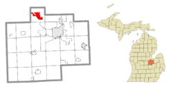
Location within Saginaw County
|
|
| Country | United States |
| State | Michigan |
| County | Saginaw |
| Township | Tittabawassee |
| Area | |
| • Total | 6.72 sq mi (17.41 km2) |
| • Land | 6.59 sq mi (17.06 km2) |
| • Water | 0.14 sq mi (0.35 km2) |
| Elevation | 623 ft (190 m) |
| Population
(2020)
|
|
| • Total | 7,630 |
| • Density | 1,158.17/sq mi (447.17/km2) |
| Time zone | UTC-5 (Eastern (EST)) |
| • Summer (DST) | UTC-4 (EDT) |
| ZIP code(s) |
48623
|
| Area code(s) | 989 |
| FIPS code | 26-30540 |
| GNIS feature ID | 2393012 |
Freeland is a community located in Tittabawassee Township, within Saginaw County in the state of Michigan. It is considered a "census-designated place" (CDP), which means it's an area the government counts for population statistics. Freeland is part of the larger Saginaw-Midland-Bay Metropolitan Area.
According to the 2020 census, about 7,630 people live in Freeland. The community covers a central part of Tittabawassee Township. The Freeland post office, with ZIP code 48623, serves almost the entire township. It also serves parts of nearby townships like Midland, Williams, Frankenlust, Kochville, Thomas, Richland, and Ingersoll Township.
Freeland is home to MBS International Airport. This airport serves three major cities nearby: Saginaw, Bay City, and Midland. It also has the Saginaw Correctional Facility, which is a prison.
Contents
History of Freeland
Early Native American Settlements
Long before European settlers arrived, Native American people lived in this area. In 1819, a special agreement called the Treaty of Saginaw was made. In this treaty, the Chippewa, Ottawa, and Pottawatomi tribes gave a large amount of land, including Saginaw County, to the United States government.
However, some areas were set aside for specific groups of Chippewa people. One of these areas was called Black Bird's Village. It was about 6,000 acres (24 km²) on the Tittabawassee River, very close to where Freeland is today.
Lumbering Outposts and Early Names
In the 1850s, small settlements for lumbering started to appear in the area. One of these was called "Loretta." In April 1856, Loretta got a post office named "Jay." This name came from the first postmaster, Jefferson Jaqruth. This settlement was almost exactly in the middle of Tittabawassee Township.
Another small settlement grew a bit further north. In 1867, a resident named George Truesdale helped move the Jay post office to this new northern settlement. The post office kept the name Jay for several more years.
How Freeland Got Its Name
The name "Freeland" comes from a woman known as "Mammy Freeland." She ran a very popular tavern by the river. Lumbermen and river workers often visited her tavern. They started calling the entire settlement "Freeland" because of her. The post office officially changed its name to Freeland in January 1879. It also became a stop on the Pere Marquette Railroad. Some say the Freeland family was important in the area's businesses and politics.
World War II and Local Events
During World War II, the airport that is now MBS International Airport was used for a different purpose. It held German and Japanese prisoners of war.
In 1985, the local Lions Clubs International chapter in Freeland started a fun yearly event. It's called the Freeland Walleye Festival.
Geography and Climate
Where Freeland Is Located
According to the United States Census Bureau, Freeland covers a total area of about 6.7 square miles (17.4 km²). Most of this area, about 6.7 square miles (17.1 km²), is land. A small part, about 0.04 square miles (0.1 km²), is water.
Freeland's Weather
Freeland experiences big changes in temperature throughout the year. Summers are warm to hot and often humid. Winters are cold, and sometimes very cold. This type of weather is known as a humid continental climate. On climate maps, it's often shown as "Dfb."
Transportation
The main road that runs through Freeland is M-47. If you drive north on M-47, you will reach US-10. If you drive south, you will go towards Thomas Township, Michigan and Saginaw, Michigan.
Notable People
- Aleda E. Lutz: She was an Army Flight Nurse during World War II. She is known as the second most decorated woman in U.S. history.
Population Data
| Historical population | |||
|---|---|---|---|
| Census | Pop. | %± | |
| 2020 | 7,630 | — | |
| U.S. Decennial Census | |||
See also
 In Spanish: Freeland (Míchigan) para niños
 | Isaac Myers |
 | D. Hamilton Jackson |
 | A. Philip Randolph |


