Ogemaw County, Michigan facts for kids
Quick facts for kids
Ogemaw County
|
||
|---|---|---|

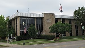
Ogemaw County Building in West Branch
|
||
|
||

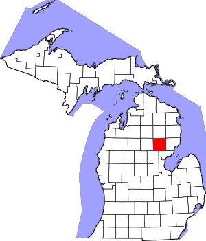
Location within the U.S. state of Michigan
|
||
 Michigan's location within the U.S. |
||
| Country | ||
| State | ||
| Founded | G, 1840 (authorized) 1875 (organized) |
|
| Seat | West Branch | |
| Largest city | Skidway Lake West Branch (incorporated) |
|
| Area | ||
| • Total | 575 sq mi (1,490 km2) | |
| • Land | 563 sq mi (1,460 km2) | |
| • Water | 11 sq mi (30 km2) 2.0%% | |
| Population
(2020)
|
||
| • Total | 20,770 | |
| • Density | 39/sq mi (15/km2) | |
| Time zone | UTC−5 (Eastern) | |
| • Summer (DST) | UTC−4 (EDT) | |
| Congressional district | 1st | |
Ogemaw County (pronounced OH-gə-maw) is a county in the state of Michigan. In 2020, about 20,770 people lived here. The main town, or county seat, is West Branch.
The local newspaper for the county is called the Ogemaw Herald.
Contents
History of Ogemaw County
Ogemaw County was first part of a large area called Virginia Land. This land was owned by England a long time ago. After the American Revolutionary War, this big area was divided into smaller pieces.
The Michigan government first created Ogemaw County in 1840. But later, in 1867, it became part of Iosco County. It was created again in 1873 and officially started working as a county in 1875.
The name "Ogemaw" comes from a Native American word, ogimaa. This word means "chief." The county was named after a respected Native American speaker known as Little Elk.
One of the first towns in the county was Ogemaw Springs. This town grew because of the lumber industry. People cut down trees and processed wood there. Railways were built to move the wood. But when there were no more trees to cut, the lumber business ended. So, the town of Ogemaw Springs became very small.
After Ogemaw Springs declined, many people moved to West Branch. This move helped West Branch grow a lot. New restaurants, hotels, and other businesses were built. Many of these buildings are still standing today.
Geography of Ogemaw County
Ogemaw County covers about 575 square miles. Most of this area, about 563 square miles, is land. The rest, about 11 square miles, is water. Ogemaw County is located in the northern part of Michigan.
Main Roads in Ogemaw County
These are the important highways that go through Ogemaw County:
 I-75 – This highway runs through the southwest part of the county. It passes south of West Branch.
 M-30 – This road enters from Gladwin County. It goes north and northeast to meet M-55 near West Branch.
 M-33 – This highway runs north and south through the middle of the county. It passes through Rose City.
 M-55 – This road goes east and west across the lower part of the county. It enters from Iosco County and goes west to meet I-75, west of West Branch.
Neighboring Counties
Ogemaw County shares borders with these other counties:
- Oscoda County - to the north
- Alcona County - to the northeast
- Iosco County - to the east
- Arenac County - to the southeast
- Gladwin County - to the southwest
- Roscommon County - to the west
- Crawford County - to the northwest
Protected Natural Areas
Ogemaw County has parts of these protected natural areas:
- Huron National Forest
- Au Sable State Forest
- Rifle River State Recreation Area
Communities in Ogemaw County
Cities
- Rose City
- West Branch (This is the county seat, where the county government is located.)
Village
Civil Townships
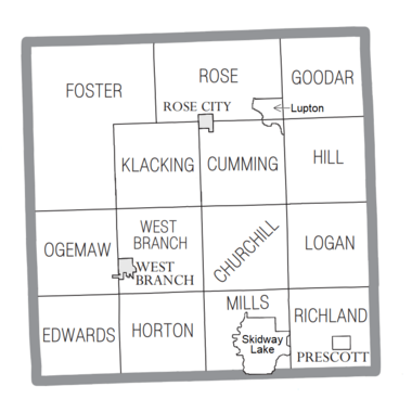
Townships are smaller local government areas. Here are the townships in Ogemaw County:
- Churchill Township
- Cumming Township
- Edwards Township
- Foster Township
- Goodar Township
- Hill Township
- Horton Township
- Klacking Township
- Logan Township
- Mills Township
- Ogemaw Township
- Richland Township
- Rose Township
- West Branch Township
Census-Designated Places
These are areas that are like towns but are not officially incorporated as cities or villages:
- Lupton
- Skidway Lake
Other Unincorporated Communities
These are smaller places that are not officially part of a city, village, or census-designated place:
- Camp Lu Lay Lea
- Campbells Corners
- Damon
- Edwards
- Elbow Lake
- Fayettes Corner
- Goodar
- Greenwood
- Ogemaw Springs
- Selkirk
- Shady Shores
- South Branch
Population of Ogemaw County
| Historical population | |||
|---|---|---|---|
| Census | Pop. | %± | |
| 1870 | 12 | — | |
| 1880 | 1,914 | 15,850.0% | |
| 1890 | 5,583 | 191.7% | |
| 1900 | 7,765 | 39.1% | |
| 1910 | 8,907 | 14.7% | |
| 1920 | 7,786 | −12.6% | |
| 1930 | 6,595 | −15.3% | |
| 1940 | 8,720 | 32.2% | |
| 1950 | 9,345 | 7.2% | |
| 1960 | 9,680 | 3.6% | |
| 1970 | 11,903 | 23.0% | |
| 1980 | 16,436 | 38.1% | |
| 1990 | 18,681 | 13.7% | |
| 2000 | 21,645 | 15.9% | |
| 2010 | 21,699 | 0.2% | |
| 2020 | 20,770 | −4.3% | |
| 2023 (est.) | 20,990 | −3.3% | |
| US Decennial Census 1790-1960 1900-1990 1990-2000 2010-2018 |
|||
In the year 2000, there were 21,645 people living in Ogemaw County. These people lived in 8,842 households, and 6,189 of those were families. By the 2020 census, the population was 20,770 people.
See also
 In Spanish: Condado de Ogemaw para niños
 | Misty Copeland |
 | Raven Wilkinson |
 | Debra Austin |
 | Aesha Ash |


