
Lupton, Michigan facts for kids
Quick facts for kids
Lupton, Michigan
|
|
|---|---|
.jpg)
Looking north along Main Street
|
|
,_MI_location.png)
Location within Ogemaw County
|
|

Lupton, Michigan
Location in Michigan

Lupton, Michigan
Location in the United States
|
|
| Country | United States |
| State | Michigan |
| County | Ogemaw |
| Townships | Cumming and Rose |
| Settled | 1880 |
| Area | |
| • Total | 3.26 sq mi (8.45 km2) |
| • Land | 3.23 sq mi (8.37 km2) |
| • Water | 0.03 sq mi (0.08 km2) |
| Elevation | 922 ft (281 m) |
| Population
(2020)
|
|
| • Total | 318 |
| • Density | 98.39/sq mi (37.99/km2) |
| Time zone | UTC-5 (Eastern (EST)) |
| • Summer (DST) | UTC-4 (EDT) |
| ZIP code(s) |
48635
|
| Area code(s) | 989 |
| GNIS feature ID | 1620647 |
Lupton is a small community in Ogemaw County, Michigan, in the United States. It is an "unincorporated community," meaning it doesn't have its own local government like a city or town. It is also a "census-designated place" (CDP), which means the U.S. Census Bureau has defined its boundaries for counting people.
In 2020, about 318 people lived in Lupton. Most of the community is located within Rose Township, with a small part extending south into Cumming Township.
Contents
History of Lupton
Lupton was first settled around 1880. Several families from Ohio moved there, including the family of Emmor Lupton. These families were Quakers, a religious group known for their peaceful beliefs.
The community was first called Lane Heights. It received its own post office, named Lane, on April 11, 1881. A train station, or "depot," was opened in January 1893. This station was part of the Detroit, Bay City and Alpena Railroad. The post office name was changed to Lupton in June 1893.
The Lupton Schoolhouse
The Lupton Schoolhouse was built between 1903 and 1904. It served the children of Lupton as the Rose Township District No. 5 School. This school had two rooms and taught students until 1963. Today, the schoolhouse is a special historical site. It was recognized as a Michigan State Historic Site on April 20, 1995.
Modern Lupton
For the first time, Lupton was officially listed as a "census-designated place" for the 2010 census. This meant it had clear boundaries and its population could be counted separately.
The local post office in Lupton closed on November 5, 2011. Even though there isn't a post office in Lupton anymore, the 48635 ZIP Code for Lupton is still used. Mail for Lupton is now handled by the post office in Rose City.
Geography of Lupton
According to the U.S. Census Bureau, Lupton covers an area of about 3.26 square miles (8.45 square kilometers). Most of this area, about 3.23 square miles (8.37 square kilometers), is land. A small part, about 0.03 square miles (0.08 square kilometers), is water.
The Rifle River flows right through Lupton. The Rifle River State Recreation Area, a place for outdoor activities, is located just south of Lupton. This recreation area also uses the Lupton ZIP Code.
Population of Lupton
| Historical population | |||
|---|---|---|---|
| Census | Pop. | %± | |
| 2020 | 318 | — | |
| U.S. Decennial Census | |||
The population of Lupton was counted during the 2020 United States census. At that time, 318 people lived in the community.
Images for kids
-
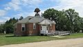
The historic Rose Township District No. 5 School in Lupton.

See also
 In Spanish: Lupton (Míchigan) para niños
