
Rifle River facts for kids
Quick facts for kids Rifle River |
|
|---|---|
 |
|
| Country | United States |
| State | Michigan |
| Counties | Ogemaw, Arenac |
| Cities | Selkirk, Omer |
| Physical characteristics | |
| Main source | Ogemaw County 44°23′58″N 84°01′57″W / 44.39944°N 84.03250°W |
| River mouth | Saginaw Bay Arenac County 577 ft (176 m) 43°59′34″N 83°49′15″W / 43.99278°N 83.82083°W |
| Length | 60 mi (97 km) |
| Basin features | |
| Basin size | 385 sq mi (1,000 km2) |
The Rifle River is a river in the state of Michigan, United States. It is about 60 miles (97 km) long. The river starts in northeastern Ogemaw County. It then flows through Arenac County. Finally, it empties into Saginaw Bay, which is part of Lake Huron.
Long ago, around the early 1900s, the Rifle River was used for logging. This means people floated cut trees down the river. Today, the river is mostly used for fun activities. It is also a special "natural river" as named by the state.
Fun on the River
The Rifle River is a very popular place for canoeing. It's great because there are no dams or places where you have to carry your canoe around obstacles. The river is usually about 18 inches (46 cm) deep. In some spots, like in downtown Omer, it can be up to 5 feet (1.5 m) deep.
In the spring, the river is known for its large numbers of White Sucker fish. These fish are a type of sucker fish. Many people come to the Rifle River to see this natural event.
.jpg)
River History
Old maps show that the Rifle River might have had a different name a long time ago. A map from 1831 suggests it was once called Grindstone Creek. This shows how names of places can change over many years.
Images for kids
-
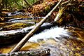
Small creeks, like this one, are formed by springs and flow into the Rifle River, helping to feed it.

