Omer, Michigan facts for kids
Quick facts for kids
Omer, Michigan
|
|
|---|---|
| City of Omer | |

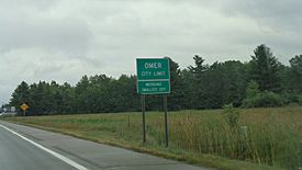
Signage along U.S. Highway 23
|
|

Location within Arenac County
|
|
| Country | United States |
| State | Michigan |
| County | Arenac |
| Settled | 1866 |
| Incorporated | 1903 |
| Government | |
| • Type | Council–manager |
| Area | |
| • Total | 1.16 sq mi (3.00 km2) |
| • Land | 1.13 sq mi (2.93 km2) |
| • Water | 0.03 sq mi (0.07 km2) |
| Elevation | 610 ft (186 m) |
| Population
(2020)
|
|
| • Total | 274 |
| • Density | 242.05/sq mi (93.42/km2) |
| Time zone | UTC-5 (Eastern (EST)) |
| • Summer (DST) | UTC-4 (EDT) |
| ZIP code(s) |
48749
|
| Area code(s) | 989 |
| FIPS code | 26-60660 |
| GNIS feature ID | 0634057 |
Omer is a small city in Arenac County, Michigan, in the United States. It is known for being the least-populated city in the state. In 2020, 274 people lived there.
Omer often holds the title of "Michigan's Smallest City" by population. Another city, Lake Angelus, was smaller in 2010. However, by 2020, Omer was once again the smallest city in Michigan.
Contents
History of Omer

Omer was started in 1866 by George Gorie and George Carscallen. They built a sawmill next to the Rifle River. The town was first called Rifle River Mills.
Carscallen, who was the first postmaster, wanted to name the town Homer. But he found out there was already a town called Homer, Michigan. So, he simply removed the "H" from Homer, and the town became Omer.
In 1872, the area was officially mapped out. Omer became part of the new Arenac County in 1883. It was officially made a city in 1903.
A big fire in 1914 destroyed 40 buildings in Omer. This fire ended the town's early growth. Two years later, a flood damaged the local dam, making it harder to rebuild.
One interesting story from Omer involves a disagreement over water service. Some households left the city because they were being charged for water but did not receive it.
Geography and Nature
Omer covers about 1.16 square miles (3.00 square kilometers). Most of this area is land, with a small part being water.
The Rifle River flows right through the city. This river is a popular spot for fishing, especially for sucker fish in the spring. Omer even hosts an annual festival and fishing tournament related to this.
Main Roads in Omer
- U.S. Highway 23 travels through Omer, running from west to east.
Population and People
| Historical population | |||
|---|---|---|---|
| Census | Pop. | %± | |
| 1910 | 367 | — | |
| 1920 | 266 | −27.5% | |
| 1930 | 216 | −18.8% | |
| 1940 | 295 | 36.6% | |
| 1950 | 321 | 8.8% | |
| 1960 | 322 | 0.3% | |
| 1970 | 366 | 13.7% | |
| 1980 | 403 | 10.1% | |
| 1990 | 385 | −4.5% | |
| 2000 | 337 | −12.5% | |
| 2010 | 313 | −7.1% | |
| 2020 | 274 | −12.5% | |
| U.S. Decennial Census | |||
Omer's Population in 2010
In 2010, there were 313 people living in Omer. These people lived in 131 households. About 94% of the residents were White, and about 4% were Native American.
The average age of people in Omer was about 40.8 years old. About 22% of residents were under 18, and about 18% were 65 or older. The number of males and females was almost equal.
See also
 In Spanish: Omer (Míchigan) para niños
 | Jessica Watkins |
 | Robert Henry Lawrence Jr. |
 | Mae Jemison |
 | Sian Proctor |
 | Guion Bluford |


