Misteguay Creek facts for kids
Quick facts for kids Misteguay Creek |
|
|---|---|

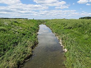
A channelized section of Misteguay Creek in Albee Township
|
|

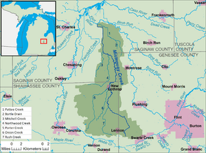
A map of Misteguay Creek and its watershed.
|
|
| Country | United States |
| State | Michigan |
| Counties | Genesee, Shiawassee, Saginaw |
| Townships | Clayton, Venice, Hazelton, Maple Grove, Albee, Spaulding |
| Municipality | New Lothrop |
| Physical characteristics | |
| Main source | Clayton Township 809 ft (247 m) 42°58′01″N 83°53′54″W / 42.9669737°N 83.8982942°W |
| River mouth | Flint River Spaulding Township 584 ft (178 m) 43°18′30″N 84°01′03″W / 43.3083596°N 84.0174739°W |
| Length | 38.4 mi (61.8 km) |
| Basin features | |
| Basin size | 174.4 sq mi (452 km2) |
| Hydrologic Unit Codes | 040802040505, 040802040509, 040802040512, 040802040506, 040802040507, 040802040508 (USGS) |
Misteguay Creek is a stream in Michigan, United States. It is about 38.4 miles (61.8 km) long. This creek is a tributary of the Flint River. A tributary is a smaller stream or river that flows into a larger one.
The creek helps drain water from a large area of land. This area is called a watershed. Misteguay Creek's watershed covers about 174.4 square miles (452 km2). Most of this land is used for farming.
Misteguay Creek is part of a bigger system of rivers. It flows into the Flint River, which then joins the Shiawassee River. Together, these rivers flow into the Saginaw River. The Saginaw River then empties into Saginaw Bay, which is part of Lake Huron. Lake Huron is one of the Great Lakes. All this water eventually makes its way to the St. Lawrence River and then to the Atlantic Ocean.
Where Misteguay Creek Flows
Misteguay Creek starts in Clayton Township in Genesee County. This is in central Michigan. It begins about 1.9 miles (3.1 km) southeast of the village of Lennon. It is also about 3.5 miles (5.6 km) west of the city of Swartz Creek.
The creek first flows northwest into Shiawassee County. Then, it generally flows northward. It passes through several townships and one village. These include Venice and Hazelton townships. It also goes through the village of New Lothrop in Shiawassee County.
After that, it flows through Maple Grove, Albee, and Spaulding townships. These are all in Saginaw County.
The creek finally flows into the Flint River in Spaulding Township. This spot is about 6.3 miles (10.1 km) east of the village of St. Charles.
What is Channelization?
You might notice that some parts of Misteguay Creek look very straight. This is because sections of the creek have been channelized. Channelization means that people have changed the natural path of the creek. They make it straighter and sometimes deeper. This is often done to help water flow faster, especially in farm areas, or to prevent flooding.
Smaller Streams Joining In
Many smaller streams and drains flow into Misteguay Creek. These are also called tributaries. They add water to the creek as it flows along. Here is a list of some of the named streams that join Misteguay Creek. The list starts with the streams closest to where Misteguay Creek ends and goes up to those closer to its beginning.
| Number | Name of Stream | Flows into | Length |
|---|---|---|---|
| 1 | Pattee Creek | Misteguay Creek | 10.7 miles (17.2 km) |
| 2 | Bortle Drain | Pattee Creek | 2.1 miles (3.4 km) |
| 3 | Mitchell Creek | Misteguay Creek | 7.7 miles (12.4 km) |
| 4 | Northwood Creek | Misteguay Creek | 11.3 miles (18.2 km) |
| 5 | Porter Creek | Misteguay Creek | 14.6 miles (23.5 km) |
| 6 | Onion Creek | Misteguay Creek | 9.2 miles (14.8 km) |
| 7 | Rush Creek | Misteguay Creek | 9.1 miles (14.6 km) |
 | Madam C. J. Walker |
 | Janet Emerson Bashen |
 | Annie Turnbo Malone |
 | Maggie L. Walker |

