Ira Township, Michigan facts for kids
Quick facts for kids
Ira Township, Michigan
|
|
|---|---|

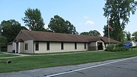
Ira Township Administrative Office
|
|

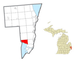
Location within St. Clair County
|
|
| Country | United States |
| State | Michigan |
| County | St. Clair |
| Established | 1837 |
| Area | |
| • Total | 21.6 sq mi (55.9 km2) |
| • Land | 17.0 sq mi (43.9 km2) |
| • Water | 4.6 sq mi (12.0 km2) |
| Elevation | 587 ft (179 m) |
| Population
(2020)
|
|
| • Total | 4,967 |
| • Density | 230.0/sq mi (88.86/km2) |
| Time zone | UTC-5 (Eastern (EST)) |
| • Summer (DST) | UTC-4 (EDT) |
| ZIP code(s) |
48004, 48023
|
| Area code(s) | 586 |
| FIPS code | 26-40920 |
| GNIS feature ID | 1626524 |
Ira Township is a cool place located in St. Clair County, Michigan. It's a "civil township," which is like a local government area. In 2020, about 4,967 people called Ira Township home. It's known for its beautiful natural areas and friendly communities.
Contents
Exploring the Communities in Ira Township
Ira Township is home to several smaller communities, each with its own story. These areas are called "unincorporated communities" because they don't have their own separate local government like a city or village.
- Anchorville is found along M-29 on the northern shore of Lake St. Clair. It was once called the "Swan Creek Settlement." A church built in 1854 became the center of the village. Later, in 1876, it was renamed Anchorville because of its location on Anchor Bay.
- Copeland Corner is another spot along M-29, near Perch Road. It's a small area within the township.
- Fair Haven is a community located a bit east of Anchorville, also on M-29. This area was originally a French-speaking settlement even before Michigan became a state in 1837. It was first called Swan Creek, but its name was changed to Fair Haven in 1862.
- Perch Point is located at the very southeast corner of Ira Township, right on the border with Clay Township. It's also found along M-29.
A Look at History
Ira Township was officially created in 1837. It was named after an early settler in the area, a man named Ira Marks. A post office called Ira even existed for a short time in the mid-1800s on the north shore of Lake St. Clair.
Nature and Geography
Ira Township covers about 21.6 square miles (55.9 km2). Most of this area, about 17.0 square miles (43.9 km2), is land, while 4.6 square miles (12.0 km2) is water. That means about 21% of the township is covered by water!
The land in Ira Township is mostly flat, rising just a little bit from the shoreline of Lake St. Clair. Much of the township is rural, meaning you'll find lots of woods, open spaces, and farms. Along the shoreline, there are homes and the Dixie Highway. You'll also find small groups of homes in places like Fair Haven and Anchorville.
The main waterway flowing through the township is Swan Creek. This creek has branches that spread out, helping to drain the land. Near the lake, the shoreline can be sandy or have seawalls. The water close to the land is usually shallow. There are also several marshy areas in the township, both along the lake and near the creeks.
Population Facts
According to the 2020 Census, 4,967 people live in Ira Township. Back in 2000, there were 6,966 people living here. The population density was about 411 people per square mile (158 people per km2).
In 2000, about 27.8% of the people living in the township were under 18 years old. About 9.6% were 65 years old or older. The average age of people in the township was 34 years.
See also
 In Spanish: Municipio de Ira para niños
 | Mary Eliza Mahoney |
 | Susie King Taylor |
 | Ida Gray |
 | Eliza Ann Grier |


