
Clinton–Kalamazoo Canal facts for kids
Quick facts for kids |
|
|
Clinton-Kalamazoo Canal
|
|
 |
|

Location in Michigan

Location in the United States
|
|
| Location | Clinton Township to Rochester |
|---|---|
| Area | 51 acres (21 ha) |
| Built | 1838 |
| NRHP reference No. | 72000638 |
| Added to NRHP | March 24, 1972 |
The Clinton–Kalamazoo Canal was a canal in Michigan that was never fully finished. It was meant to connect Lake St. Clair with Lake Michigan. People wanted to build it because the Erie Canal in New York was very successful.
After Michigan became a state in 1837, its first governor, Stevens Thomson Mason, started a big plan. This plan included building important things like railroads and canals. On March 21, 1837, the state government allowed Governor Mason to borrow money for these projects. One of these projects was the Clinton-Kalamazoo Canal. In the spring of 1838, a group of seven people was chosen to manage the canal project.
History of the Canal

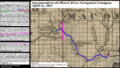
The Clinton–Kalamazoo Canal was supposed to start in Mount Clemens. It would follow the Clinton River. Then it would go through towns like Utica, Rochester, Pontiac, Howell, and Hastings. Finally, it would reach the Kalamazoo River.
The canal was planned to be 216 miles long. From Pontiac westward, it would help new settlers and supplies move into Michigan. It would also connect to a busy port on Lake Michigan called Singapore. Singapore is now a ghost town, meaning it no longer exists. From Singapore, people and goods would travel across Lake Michigan to Chicago.
Before the canal, people thought the Clinton River could be used for boats. In 1827, a company called the 'Clinton River Navigation Company' was formed. Their goal was to clear the Clinton River. They wanted to make it easy for boats to travel from Mount Clemens to Oakland County. This project was important for farmers to ship their goods. However, the idea of building railroads soon became more popular.
Construction on the canal began in 1838 with great excitement. But soon, money problems hit. A big financial crisis called the Panic of 1837 caused funding for the canal to disappear. All construction stopped in 1843. Only 13 miles of the canal had been completed. Many workers were not paid, and some even damaged parts of the canal. Some parts of the canal were also damaged by people trying to steal materials.
There were also engineering mistakes. The canal was dug too shallow and too narrow. This meant it could not handle large boats carrying heavy goods. Around 1844, a man named Amos Brown tried to launch a flatboat on the canal. But when he reached the first lock, his boat was too wide to fit. The wooden locks had warped and shrunk.
A dam was built at Frederick to supply water to the locks. By 1845, small boats were running from Utica to Frederick. However, the canal did not make much money for the state. In 1845, it earned only $46.90 from tolls. The income kept dropping, and by 1848, the canal was no longer used. After construction stopped, the canal quickly fell apart. Some parts were later used to power watermills until the 1940s. The Clinton-Kalamazoo Canal was added to the National Register of Historic Places in 1972. Today, signs and historic markers show where the canal once ran.
Today's Remnants
You can still see parts of the canal today. Remnants are visible in Rochester Hills in Oakland County. You can also find them in Shelby Township, Utica, and Clinton Township in Macomb County.
Much of the canal is easy to see in parks and along Canal Road in Clinton Township. In River Bends Park, hiking and mountain biking trails run along the canal's edge. You can see the remains of an aqueduct, which is like a bridge for water, over the Clinton River in Yates Park. Two old wooden dams are visible in the river at Canal Park and Bloomer Park. No locks are visible along the canal today, but their original locations are known.
Images for kids
-
Incorporation of the Clinton River Navigation Company, 1827

