Madison Heights, Michigan facts for kids
Quick facts for kids
Madison Heights, Michigan
|
|||
|---|---|---|---|

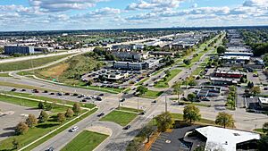
Aerial view of Madison Heights
|
|||
|
|||

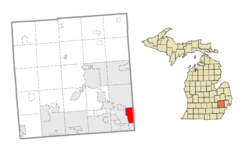
Location within Oakland County
|
|||
| Country | United States | ||
| State | Michigan | ||
| County | Oakland | ||
| Incorporated | 1955 | ||
| Area | |||
| • City | 7.09 sq mi (18.35 km2) | ||
| • Land | 7.09 sq mi (18.35 km2) | ||
| • Water | 0.00 sq mi (0.00 km2) | ||
| Elevation | 633 ft (193 m) | ||
| Population
(2020)
|
|||
| • City | 28,468 | ||
| • Density | 4,017.50/sq mi (1,551.15/km2) | ||
| • Metro | 4,296,250 (Metro Detroit) | ||
| Time zone | UTC-5 (EST) | ||
| • Summer (DST) | UTC-4 (EDT) | ||
| ZIP code(s) |
48071
|
||
| Area code(s) | 248 and 947 | ||
| FIPS code | 26-50560 | ||
| GNIS feature ID | 0631311 | ||
Madison Heights is a city in Oakland County, Michigan, in the United States. It is a suburb located about 12 miles (19 km) north of downtown Detroit. In 2020, the city had a population of 28,468 people.
Contents
History of Madison Heights
Madison Heights was once part of Royal Oak Township. On January 17, 1955, people voted to make it a city. It officially became a city on December 6, 1955. This made it the tenth city government in southern Oakland County.
At that time, the city was about 7.2 square miles (18.6 km²) large. This made it one of the biggest suburbs in the Metro Detroit area. The first city hall was at 26305 John R Road. A new city building opened on April 5, 1963, at 300 West Thirteen Mile Road, where it is today.
The city is located near the Interstate 696 (I-696) and I-75 highways. Madison Heights has two main public school districts: Lamphere and Madison. It also has a full city government that provides services to its residents.
Geography and Location
According to the United States Census Bureau, Madison Heights covers a total area of 7.09 square miles (18.35 km²). All of this area is land.
Most buildings in Madison Heights are single-family homes or condominiums. About 91% of the buildings are homes. However, 60% of the city's tax money comes from businesses and light industrial properties. The city has 15 voting areas and more than 21,000 registered voters.
Neighboring Cities
Madison Heights shares its borders with several other cities:
- Troy to the north
- Royal Oak to the west
- Hazel Park to the south
- Warren to the east
The eastern border of Madison Heights, which is Dequindre Road, also marks the border between Oakland and Macomb counties.
Roads and Highways
There are over 112 miles (180 km) of roads in Madison Heights. The city takes care of 105 miles (169 km) of these roads. This includes removing snow, sweeping, and fixing potholes.
Interstate 75 runs through the west side of the city, going north to south. Interstate 696 is a major highway along the city's southern border. These two highways meet at a junction shared with Royal Oak and Hazel Park, in the southwest part of Madison Heights.
Population and People
| Historical population | |||
|---|---|---|---|
| Census | Pop. | %± | |
| 1960 | 33,343 | — | |
| 1970 | 38,599 | 15.8% | |
| 1980 | 35,375 | −8.4% | |
| 1990 | 31,296 | −11.5% | |
| 2000 | 31,101 | −0.6% | |
| 2010 | 29,694 | −4.5% | |
| 2020 | 28,468 | −4.1% | |
| U.S. Decennial Census | |||
2020 Census Information
In 2020, the city of Madison Heights had 28,468 people living in 13,487 households. There were about 4,017.5 people per square mile.
The population included:
- 80.4% White
- 7.8% African American
- 0.2% Native American
- 7.2% Asian
- 0.1% Pacific Islander
- 3.6% from two or more races
About 2.0% of the population were Hispanic or Latino (of any race).
About 14.7% of households spoke a language other than English at home. Also, 11.1% of people under 65 had a disability. About 11.7% of the city's population lived below the federal poverty line. About 11.9% of homes did not have a broadband internet connection.
- 16% of residents were under 18 years old.
- 16.3% were 65 years old or older.
- 49.4% of the population was male, and 50.6% was female.
Asian Community in Madison Heights
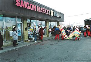
In 2008, about 1.9% of the people in Madison Heights were of Vietnamese descent. The city is home to 168 Asian Mart, a very large Asian supermarket. It covers about 38,000 square feet (3,530 m²). This makes it one of the biggest Asian supermarkets in southeast Michigan. The Chinese Cultural Center is also located in Madison Heights.
Economy and Businesses
Madison Heights is part of Oakland County's Automation Alley. This area is known for its technology and manufacturing businesses. The city has more than 1,300 commercial and industrial businesses. Most of these are small businesses. However, there are also over 100 major companies within the city's 7.2 square miles (18.6 km²).
The city has many places for shopping and business:
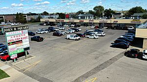
- 23 shopping centers
- 11 hotels
- More than 860,000 square feet (80,000 m²) of office space
- Seven industrial parks with over 10,000,000 square feet (929,000 m²) of space
The main office for Hungry Howie's Pizza is in Madison Heights. Also, the Telway Hamburger System is a well-known 24-hour restaurant. It is famous for its small hamburgers called sliders and its unique customers late at night.
Education and Schools
Public schools in Madison Heights are served by two main districts:
- Madison District Public Schools
- Lamphere Public Schools
There are also other schools in the city:
- Bishop Foley Catholic High School is a private school.
- Four Corners Montessori Academy is a public charter school.
Notable People
Many interesting people have connections to Madison Heights:
- Terrence Berg, a federal judge
- Monte Geralds, a Michigan legislator
- George Steele, a professional wrestler
- Robert Wyland, a mural artist
See also
 In Spanish: Madison Heights para niños
 | James B. Knighten |
 | Azellia White |
 | Willa Brown |


