Pleasant Ridge, Michigan facts for kids
Quick facts for kids
Pleasant Ridge
|
|||
|---|---|---|---|
| City of Pleasant Ridge | |||

|
|||
|
|||

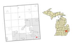
Location within Oakland County
|
|||
| Country | United States | ||
| State | Michigan | ||
| County | Oakland | ||
| Founded | 1913 | ||
| Incorporated | 1921 (village) 1927 (city) |
||
| Government | |||
| • Type | City commission | ||
| Area | |||
| • City | 0.57 sq mi (1.48 km2) | ||
| • Land | 0.57 sq mi (1.48 km2) | ||
| • Water | 0.00 sq mi (0.00 km2) | ||
| Elevation | 650 ft (195 m) | ||
| Population
(2020)
|
|||
| • City | 2,627 | ||
| • Density | 4,608.77/sq mi (1,779.46/km2) | ||
| • Metro | 4,392,041 (Metro Detroit) | ||
| Time zone | UTC−5 (EST) | ||
| • Summer (DST) | UTC−4 (EDT) | ||
| ZIP Code |
48069
|
||
| Area code(s) | 248 | ||
| FIPS code | 26-64900 | ||
| GNIS feature ID | 635117 | ||
Pleasant Ridge is a small city in Oakland County, Michigan, in the United States. It is a close neighbor to Detroit, located about 11 miles (18 km) northwest of downtown. In 2020, about 2,627 people lived here.
Pleasant Ridge is one of Michigan's smallest cities by land area. It covers only about 0.57 square miles (1.48 square kilometers).
Contents
History of Pleasant Ridge
Pleasant Ridge began in 1913 when Burt Taylor divided a large farm into smaller plots for homes. The community first became a village within Royal Oak Township in 1921. Later, in 1927, it became its own independent city. People believe the city's name comes from Ridge Road, which was a main street there.
One famous place in the city was Hedge's Wigwam. This restaurant had a Native American theme and was open from 1927 until 1967.
Pleasant Ridge was also very active in the early 1960s. Citizens worked to stop the building of a part of Interstate 696 through their city.
Historic Areas in Pleasant Ridge
Pleasant Ridge has special areas known for their history and old buildings. These are:
Geography and Location
According to the U.S. Census Bureau, Pleasant Ridge covers a total area of 0.57 square miles (1.48 square kilometers), and all of it is land.
Pleasant Ridge is surrounded by several other cities:
- Oak Park is to the west.
- Huntington Woods is to the northwest.
- Royal Oak is to the northeast.
- Ferndale is to the south and east.
The city is divided by Woodward Avenue (M-1). The area west of Woodward Avenue has larger homes and is part of the Pleasant Ridge Historic District. The area east of Woodward has more modest homes.
Main Roads in Pleasant Ridge
Two important roads run through or along Pleasant Ridge:
 I-696 (Walter P. Reuther Freeway) forms the entire northern border of the city. The Detroit Zoo is just across this highway in the cities of Huntington Woods and Royal Oak.
 M-1 (Woodward Avenue) runs north and south through the middle of the city. It is part of the important Woodward Corridor.
Population Information
| Historical population | |||
|---|---|---|---|
| Census | Pop. | %± | |
| 1920 | 472 | — | |
| 1930 | 2,885 | 511.2% | |
| 1940 | 3,391 | 17.5% | |
| 1950 | 3,594 | 6.0% | |
| 1960 | 3,807 | 5.9% | |
| 1970 | 3,989 | 4.8% | |
| 1980 | 3,217 | −19.4% | |
| 1990 | 2,775 | −13.7% | |
| 2000 | 2,594 | −6.5% | |
| 2010 | 2,526 | −2.6% | |
| 2020 | 2,627 | 4.0% | |
| U.S. Decennial Census | |||
In 2020, the city of Pleasant Ridge had a population of 2,627 people.
Population Details (2010)
[[As of|2010|alt=As of the census of 2010]], there were 2,526 people living in Pleasant Ridge. The population density was about 4,432 people per square mile (1,711 people per square kilometer).
Most residents were White (94.7%). There were also African American (1.9%), Native American (0.1%), Asian (1.1%), and people of two or more races (1.9%). About 1.7% of the population identified as Hispanic or Latino.
The average age in the city was 43.4 years. About 20.3% of residents were under 18 years old.
Education
The entire city of Pleasant Ridge is served by Ferndale Public Schools. The main office for this school district is located south of Pleasant Ridge in the city of Ferndale.
See also
 In Spanish: Pleasant Ridge para niños
 | Kyle Baker |
 | Joseph Yoakum |
 | Laura Wheeler Waring |
 | Henry Ossawa Tanner |


