Keego Harbor, Michigan facts for kids
Quick facts for kids
Keego Harbor, Michigan
|
|
|---|---|
| City of Keego Harbor | |

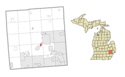
Location within Oakland County
|
|
| Country | United States |
| State | Michigan |
| County | Oakland |
| Incorporated | 1955 |
| Government | |
| • Type | Council–manager |
| Area | |
| • City | 0.57 sq mi (1.47 km2) |
| • Land | 0.49 sq mi (1.28 km2) |
| • Water | 0.07 sq mi (0.19 km2) |
| Elevation | 932 ft (284 m) |
| Population
(2020)
|
|
| • City | 2,764 |
| • Density | 5,583.84/sq mi (2,153.87/km2) |
| • Metro | 4,296,250 (Metro Detroit) |
| Time zone | UTC-5 (EST) |
| • Summer (DST) | UTC-4 (EDT) |
| ZIP code(s) |
48320
|
| Area code(s) | 248 |
| FIPS code | 26-42460 |
| GNIS feature ID | 0629495 |
Keego Harbor is a small city in Oakland County, Michigan. It's a northern suburb of Detroit, located about 27 miles (43 km) from downtown Detroit. Keego Harbor is also about 3 miles (5 km) southwest of Pontiac. In 2010, the city had 2,970 people living there. It is one of the smallest cities in Michigan by land area.
Contents
Keego Harbor's Story
The first non-native people settled in the Keego Harbor area between 1825 and 1830. Cass Lake attracted many wealthy people who bought land there for vacations. In 1890, a railway line was built through Keego Harbor. This made it much easier to travel to and from Detroit and Pontiac.
Around 1900, a lawyer from Pontiac named Joseph E. Sawyer bought land near Orchard Lake. He dug a canal to connect the smaller Dollar Lake to Cass Lake. He called this area a "harbor" on the eastern side of Cass Lake. He named the area "Keego." This name came from "giigoonh," an Anishinaabemowin word meaning "fish." The spelling "Keego" was inspired by Henry Wadsworth Longfellow's poem, The Song of Hiawatha. Keego Harbor was originally part of West Bloomfield Township. It became its own independent city in 1955.
Where is Keego Harbor?
Keego Harbor is a small city with a total area of about 0.55 square miles (1.42 square kilometers). Most of this area, about 0.50 square miles (1.29 square kilometers), is land. The rest, about 0.05 square miles (0.13 square kilometers), is water.
The small Dollar Lake and its canal are still inside Keego Harbor. The city is on the eastern shore of Cass Lake. It is surrounded by other towns and townships. These include Sylvan Lake to the east, Orchard Lake Village to the southwest, Waterford Township to the north, and West Bloomfield Township to the south and northwest.
People of Keego Harbor
| Historical population | |||
|---|---|---|---|
| Census | Pop. | %± | |
| 1960 | 2,761 | — | |
| 1970 | 3,092 | 12.0% | |
| 1980 | 3,083 | −0.3% | |
| 1990 | 2,932 | −4.9% | |
| 2000 | 2,769 | −5.6% | |
| 2010 | 2,970 | 7.3% | |
| 2020 | 2,764 | −6.9% | |
| U.S. Decennial Census | |||
According to the 2010 census, 2,970 people lived in Keego Harbor. There were 1,292 households. The city had a population density of about 5,940 people per square mile (2,293.4 per square kilometer).
Many different people live in Keego Harbor. About 24.8% of the residents were under 18 years old. The average age in the city was 35.6 years.
Learning in Keego Harbor
Students in Keego Harbor attend schools within the West Bloomfield School District.
See also
 In Spanish: Keego Harbor para niños
 | Precious Adams |
 | Lauren Anderson |
 | Janet Collins |


