
National Register of Historic Places listings in Oakland County, Michigan facts for kids

Oakland County, Michigan, is home to many amazing places that are part of history! These special spots are called Registered Historic Places. They are recognized by the United States government because they are important for their history, architecture, or what they mean to our culture.
This list will take you on a journey through some of these cool places in Oakland County. You'll learn about old homes, unique buildings, and even a famous zoo!
Contents
Historic Buildings and Homes
Many old houses and buildings in Oakland County have stories to tell. They show us how people lived and what buildings looked like long ago.
Cool Houses to Discover
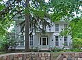
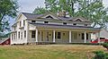
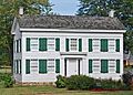
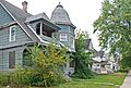
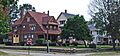
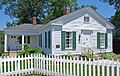
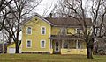
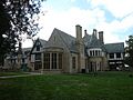
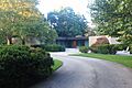
- Gregor S. and Elizabeth B. Affleck House: This unique home in Bloomfield Hills was built in 1985. It's a great example of interesting architecture.
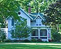
- Eli and Sidney Teeter Albertson House: Located in Oakland Township, this house was added to the list in 2002.
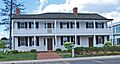
- Royal Aldrich House: You can find this historic home in Farmington Hills, recognized in 1994.
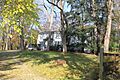
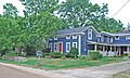
- Andrews-Leggett House: This house in Commerce Township became a historic place in 1987.
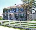
- Botsford-Graser House: Another Farmington Hills gem, listed in 2002.
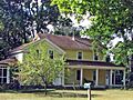
- Caswell House: Built in 1832 by Solomon and Hulda Caswell, this house in Troy is a fantastic example of Greek Revival architecture. It was moved in 1968 and is now part of the Troy Historic Village.
- John & Mary Elizabeth Booth Endicott House: This beautiful house in Bloomfield Hills was added to the list in 2008.
- Caleb Everts House: Found in Davisburg, this home has been a historic site since 1980.
- Dr. Henry K. Foote House: Located in Milford, this house was recognized in 1985.
- Horatio N. Howard House: This Pontiac house became historic in 1984.
- Hubbard-Kesby House: In Milford, this house was listed in 1996.
- John W. Hunter House: This Birmingham house was recognized in 1972.
- Kittie C. McCoy House: A historic home in Commerce Township, listed in 2009.
- Milo Prentice Newberry House: This house in Rochester was added to the list in 2018.
- H. Augustus and Agnes Cleveland O'Dell House-Inch House: Located in Bloomfield Hills, this house was listed in 2009.
- Rowe House: Northwest of Milford, this house became historic in 1975.
- Thomas W. and Margaret Taliaferro House: This Bloomfield Hills home was added in 2011.
- Charles Torrey House: In Bloomfield Township, this house was recognized in 1992.
- Walbri Hall: A historic building in Bloomfield Hills, listed in 2022.
- Wisner House: This Pontiac house was recognized in 1970.
- Minoru and Teruko (Hirashiki) Yamasaki House: This home in Bloomfield Hills was designed by the famous architect Minoru Yamasaki himself in 1972 and listed in 2013.
Special Buildings and Sites
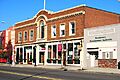
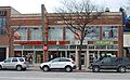
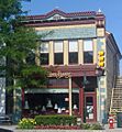
- B and C Grocery Building: This building in Royal Oak was built in 1946. It has a cool Art Modern style front made of metal panels. It was a grocery store until 2002!
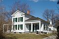
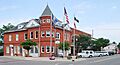
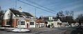
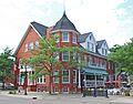
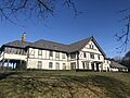
- Botsford Inn: A historic inn in Farmington, recognized in 1979.
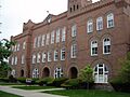
- Central School: This old school building in Pontiac was listed in 1984.
- Eagle Theater: An old theater in Pontiac, recognized in 1984.
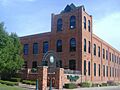
- Grinnell Brothers Music House: This music house in Pontiac was added to the list in 1984.
- Hilzinger Block: Completed in 1925 for the Hilzinger Hardware Store in Royal Oak. The store was there until 2002!
- Holly Hotel: This historic hotel in Holly was listed in 1980.
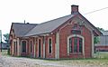
- Holly Union Depot: An old train station in Holly, recognized in 2000.
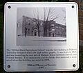
- Milford Rural Agricultural School: This school in Milford was added to the list in 1992.
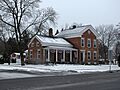
- Myrick-Palmer House: A historic house in Pontiac, recognized in 1970.
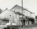
- Ortonville Mill: This old mill in Ortonville was listed in 1971.
- Rollin Sprague Building-Old Stone Store: A historic building in Rochester, recognized in 1999.
- St. Vincent DePaul Catholic Church, Convent, and School: This church in Pontiac was built in 1885. It's a significant religious site.
- Western Knitting Mills: An old knitting mill in Rochester, listed in 2000.
Historical Districts and Communities
Some areas have many historic buildings grouped together, forming a "historic district." These districts give us a glimpse into how whole towns or communities looked and functioned in the past.
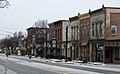
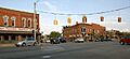
- Clarkston Village Historic District: This district in Clarkston Village includes over 100 historic buildings! It's located along M-15 and has many streets with old-time charm.
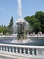
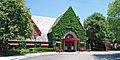
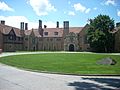
- Cranbrook Educational Community: Founded in the early 1900s by newspaper owner George Gough Booth in Bloomfield Hills. It started as a farm and grew into a famous educational center. It includes schools, an art academy, an art museum, a science institute, and beautiful gardens. Many parts were designed by famous architects like Albert Kahn and Eliel Saarinen.
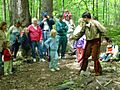
- Detroit Finnish Co-operative Summer Camp: This camping spot in Wixom was started in 1925 by people of Finnish descent. They wanted to keep their traditions alive and share them.
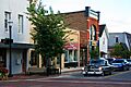
- Downtown Holly Commercial District: This area in Holly is full of historic businesses and buildings. It was recognized in 1986.
- Eastern Michigan Asylum Historic District: This was once a large psychiatric hospital in Pontiac, built in 1878. It was designed by Elijah E. Myers, who also designed the Michigan State Capitol. The hospital closed in 1997 and was torn down in 2000, but the historic district still marks its important past.
- Fairgrove Avenue Historic District: A historic neighborhood in Pontiac, recognized in 1985.
- Farmington Historic District: This district in Farmington includes Grand River Avenue and Shiawassee Avenue, showing the town's early development.
- Franklin Historic District: Located in Franklin, this district was first recognized in 1969 and later expanded.
- Franklin Boulevard Historic District: Another historic area in Pontiac, recognized in 1983.
- Lake Orion Historic District: This district in Lake Orion was listed in 2006.
- Lathrup Village Historic District: A historic area in Lathrup Village, recognized in 1998.
- Modern Housing Corporation Addition Historic District: This district in Pontiac was listed in 1989.
- North Milford Village Historic District: This historic area in Milford was recognized in 2000.
- Northland Gardens: A historic neighborhood in Southfield, listed in 2020.
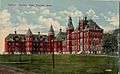
- Orchard Lake Schools Historic District: This area in Orchard Lake was home to the Michigan Military Academy, an all-boys military school, from 1877 to 1908. Later, a Polish Seminary bought the campus, and it's now home to SS. Cyril and Methodius Seminary and St. Mary's Preparatory.
- Oxford Downtown Historic District: The downtown area of Oxford, recognized in 2019.
- Pleasant Ridge East Historic District: This historic neighborhood in Pleasant Ridge was listed in 2007.
- Pleasant Ridge Historic District: Another historic district in Pleasant Ridge, first recognized in 1992 and later expanded.
- Plumbrooke Estates: A historic neighborhood in Southfield, listed in 2019.
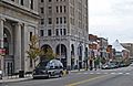
- Pontiac Commercial Historic District: This district covers the main business area of Pontiac, recognized in 1984 and later expanded.
- Stony Creek Village Historic District: Northeast of Rochester, this village district was recognized in 1972.
- Waterford Village Historic District: This historic village area in Waterford Township was listed in 1979.
Parks, Bridges, and Other Unique Sites
Oakland County also has historic parks, bridges, and other interesting places that are important to its past.
- Apple Island Historic Archaeological Site: This island in Orchard Lake Village is an archaeological site, meaning it holds clues about ancient human activity. It was listed in 2018.
- Axford-Coffin Farm: This historic farm in Oakland Township was recognized in 2002.
- Brooks Farm: Also known as the William Brooks Farm or Washington Stanley Farm, this Troy farm has an 1852 farmhouse. It was farmed by the Stanley family from 1826-1911 and then used as a dairy farm by the Brooks family. Today, it's the headquarters of the Kresge Foundation.
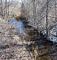
- Clinton-Kalamazoo Canal: This canal was started in 1838 to connect Mount Clemens to the Kalamazoo River. However, only 13 miles were finished before funding ran out in 1843. Parts of this historic canal can still be seen in Oakland County.
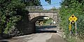
- Derby Street-Grand Trunk Western Railroad Bridge: This bridge in Birmingham, which goes over the Grand Trunk Western Railroad, was listed in 2000.
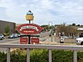
- Detroit Zoological Park: The famous Detroit Zoo in Huntington Woods and Royal Oak opened in 1928. It's a huge park with over 3,300 animals and gets more than a million visitors every year! It was recognized as a historic district in 1990.
- Gillespie Street-Clinton River Bridge: This bridge in Pontiac, crossing the Clinton River, was listed in 2000.
- Grand Trunk Western Railroad Birmingham Depot: This old train station in Birmingham was recognized in 1985.
- Griggs Brothers-Rochester Elevator Company Grain Elevator: This wooden grain elevator in Rochester, built in 1880, was very important for farming in the area for many years. It was listed in 2010.
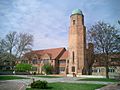
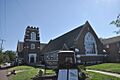
- Highland United Methodist Church: This beautiful Gothic Revival church in Highland was built in 1886. An old schoolhouse from 1835 was even moved to the site! Today, it's used by the Huron Valley Council for the Arts.
- Indian Lake Road Stone Arch Bridge: This stone bridge in Orion Township, built in 2005, is now part of a walking and biking path.
- Lower Trout Lake Bathhouse Complex and Contact Station: Located near Auburn Hills, this complex in the Bald Mountain Recreation Area was listed in 2013.
- Meadow Brook Hall: Also known as Meadow Brook Farm, this amazing Tudor Revival mansion in Rochester was built between 1926 and 1929. It was the home of Matilda Dodge Wilson, the widow of auto pioneer John Francis Dodge. In 1957, the mansion and its land were given to start Michigan State University–Oakland, which is now Oakland University.
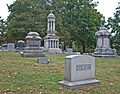
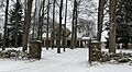
- Oak Hill Cemetery: This historic cemetery in Pontiac was recognized in 1989.
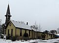
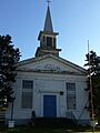
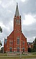
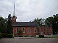
- Sashabaw Presbyterian Church: Northeast of Clarkston, this church was built in 1856. It's still used by the Sashabaw United Presbyterian Church today.
- William Edmund and Nina A. Downey Scripps Estate: Also called the Scripps Mansion or Moulton Manor, this Tudor Revival mansion in Lake Orion was built in 1927 by William Edmund Scripps. It now serves as a Catholic guest house and retreat center.
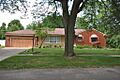
- Melvyn Maxwell and Sara Stein Smith House: This unique home in Bloomfield Township, also known as Myhaven, was designed by the famous architect Frank Lloyd Wright and built in 1949-1950. The owners were public school teachers on a budget!
- Trowbridge Road-Grand Trunk Western Railroad Bridge: This bridge in Bloomfield Hills, crossing the Grand Trunk Western Railroad, was listed in 2000.
Images for kids
-

Gregor S. and Elizabeth B. Affleck House
-
Eli and Sidney Teeter Albertson House
-
Royal Aldrich House
-
Andrews-Leggett House
-
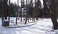
Apple Island Historic Archaeological Site
-
Axford-Coffin Farm
-

B and C Grocery Building
-
Botsford Inn
-
Botsford-Graser House
-
Brooks Farm
-

Casa del Rey Apartments
-
Caswell House
-

Central School
-
Clarkston Village Historic District
-
Clinton-Kalamazoo Canal
-
Cranbrook Educational Community
-
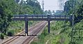
Derby Street-Grand Trunk Western Railroad Bridge
-

Detroit Finnish Co-operative Summer Camp
-
Detroit Zoological Park
-
Downtown Holly Commercial District
-

Eagle Theater
-
Eastern Michigan Asylum Historic District
-

John & Mary Elizabeth Booth Endicott House
-

Caleb Everts House
-
Fairgrove Avenue Historic District
-
Farmington Historic District
-
First Methodist Episcopal Church of Farmington
-
Dr. Henry K. Foote House
-
Franklin Boulevard Historic District
-
Franklin Historic District
-

Gillespie Street-Clinton River Bridge
-
Grand Trunk Western Railroad Birmingham Depot
-

Griggs Brothers-Rochester Elevator Company Grain Elevator
-

Grinnell Brothers Music House
-
Highland United Methodist Church
-
Hilzinger Block
-
Holly Hotel
-
Holly Union Depot
-

Horatio N. Howard House
-
Hubbard-Kesby House
-
John W. Hunter House
-
Indian Lake Road Stone Arch Bridge
-
Lake Orion Historic District
-
Lathrup Village Historic District
-

Lower Trout Lake Bathhouse Complex and Contact Station
-
Kittie C. McCoy House
-
Meadow Brook Hall
-
Milford Rural Agricultural School
-

Modern Housing Corporation Addition Historic District
-
Myrick-Palmer House
-
North Milford Village Historic District
-
Oak Hill Cemetery
-
Orchard Lake Schools Historic District
-
Ortonville Mill
-
Oxford Downtown Historic District
-

Pleasant Ridge East Historic District
-

Pleasant Ridge Historic District
-
Pontiac Commercial Historic District
-
Rowe House
-
Sashabaw Presbyterian Church
-
William Edmund and Nina A. Downey Scripps Estate
-

Melvyn Maxwell and Sara Stein Smith House
-
Rollin Sprague Building-Old Stone Store
-
St. Vincent DePaul Catholic Church, Convent, and School
-
Stony Creek Village Historic District
-
Thomas W. and Margaret Taliaferro House
-

Charles Torrey House
-

Trowbridge Road-Grand Trunk Western Railroad Bridge
-
Walbri Hall
-
Waterford Village Historic District
-
Western Knitting Mills
-

Wisner House
-
Minoru and Teruko (Hirashiki) Yamasaki House
-
Robert Yerkes House


