Erie Township, Michigan facts for kids
Quick facts for kids
Erie Township, Michigan
|
|
|---|---|

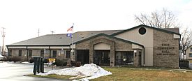
Erie Township Hall
|
|

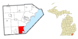
Location within Monroe County and the state of Michigan
|
|
| Country | United States |
| State | Michigan |
| County | Monroe |
| Established | 1827 |
| Area | |
| • Total | 29.59 sq mi (76.6 km2) |
| • Land | 23.88 sq mi (61.8 km2) |
| • Water | 5.72 sq mi (14.8 km2) |
| Elevation | 584 ft (178 m) |
| Population
(2020)
|
|
| • Total | 4,299 |
| • Density | 180.0/sq mi (69.5/km2) |
| Time zone | UTC-5 (Eastern (EST)) |
| • Summer (DST) | UTC-4 (EDT) |
| ZIP Codes |
48133 (Erie)
48182 (Temperance) |
| Area code(s) | 734 |
| FIPS code | 26-26320 |
| GNIS feature ID | 1626245 |
Erie Township is a community in Monroe County, Michigan, in the United States. It is called a civil township, which is a type of local government area. In 2020, about 4,299 people lived here.
Erie Township is located in the very southeast part of Michigan. It shares a border with Toledo, Ohio, a city in Ohio. It's also about 45 miles (72 km) southwest of Detroit. The township is part of a larger area called the Detroit–Warren–Ann Arbor Combined Statistical Area, also known as Metro Detroit.
The township was officially started in 1827. It is the most southeastern local government area in Michigan. The city of Luna Pier is mostly surrounded by Erie Township. However, Luna Pier became its own city in 1963, so it has its own government.
Contents
Exploring Erie Township's Past
Erie Township began around 1790. Early settlers, including Métis people, moved south from Monroe. They built a log church called St. Joseph sur la Baie Miami. A priest named Father Gabriel Richard often held church services there.
How Erie Township Was Formed
Erie Township was one of the first five townships created in Monroe County in 1827. Back then, it was much bigger. It included areas that are now Bedford and La Salle townships. It also had a small part of what was called the Toledo Strip.
When a post office opened in 1827, it was named "Bay Settlement." The township's name changed to Erie in 1835. Bedford Township and La Salle Township became separate townships in 1836. That same year, the part of Erie Township in the Toledo Strip was given to Ohio.
Luna Pier, located in the northeast, became a city in 1963. This meant it was no longer part of Erie Township.
Changes to the Township Borders
The last change to Erie Township's border happened in 1973. The Supreme Court of the United States helped settle a disagreement about a small island. This island was called Turtle Island. It is about 2 miles (3.2 km) offshore in Lake Erie.
The island is only about 1.5 acres (0.61 ha) big. It was divided in half. One side was given to Erie Township. The other side, which has an old lighthouse, was given to Ohio.
Communities Within Erie Township
Erie Township is home to several smaller communities, some of which are historic.
- Alexis was a settlement that started in 1878. It was a place where two railway lines met, heading south from Detroit. It was also known as Detroit Junction.
- Erie is a community without its own separate government. It is in the northwest part of the township. It was first settled around 1790 by people from Frenchtown. It had a post office called "Bay Settlement" starting in 1827. The name changed to "Erie" in 1835, and the post office is still open today.
- Havre was a settlement located about 1.5 miles (2.4 km) north of the state border. It was on the north side of Maumee Bay. A post office was open there for a very short time in 1837.
- Vienna is a historic spot that started in 1882. It was a stop on the Michigan Central Railroad line.
- Vistula was a settlement that used to be within the township's old borders. A company bought and planned out this community in 1832. A post office opened in Vistula in 1834 but closed quickly in 1835. This happened during the start of the Toledo War, a border dispute. When the border issue was fixed in 1836, Vistula became part of Ohio. Today, parts of the old settlement are in the Vistula Historic District in Toledo.
Understanding Erie Township's Geography
Erie Township covers a total area of about 29.59 square miles (76.64 km²). About 23.88 square miles (61.85 km²) of this is land, and 5.72 square miles (14.81 km²) is water. This means about 19% of the township is water.
Islands and Waterways
Erie Township includes a few islands in Lake Erie. These are Gard Island, Indian Island, and part of Turtle Island. The Ottawa River flows through the southeast part of the township. It empties into North Maumee Bay within the township.
The township also contains the North Maumee Bay Archeological District. This area has important historical sites. Parts of the Detroit River International Wildlife Refuge are also in the township.
The Lost Peninsula
A unique part of Erie Township is the Lost Peninsula. It is in the very southeast corner of the township. This area is on the Point Place Peninsula. The Ottawa River is to its west, and Maumee Bay is to its east.
The Lost Peninsula is an exclave. This means it is a piece of land that belongs to Erie Township (and Michigan) but is separated from the main part. Its only land border is with Ohio. The Toledo neighborhood of Point Place borders the Lost Peninsula to the south.
Neighboring Areas
Erie Township has borders with several other places:
- Lake Erie to the east.
- Bedford Township to the west.
- La Salle Township to the north.
- The city of Luna Pier to the northeast.
- The state of Ohio to the south, including parts of Toledo and Washington Township.
Major Roads in Erie Township
Several important highways pass through Erie Township, helping people travel around.
 I-75 runs north and south through the eastern part of the township. It has one exit at Otter Creek Road (exit 9).
 US 24 (Telegraph Road) also runs north and south through the middle of the township.
- M-125 (S. Dixie Highway) runs next to US 24.
 US 25 was an older highway that existed from 1926 to 1973. It has now been replaced by M-125.
Who Lives in Erie Township?
| Historical population | |||
|---|---|---|---|
| Census | Pop. | %± | |
| 1850 | 1,144 | — | |
| 1860 | 1,362 | 19.1% | |
| 1870 | 1,527 | 12.1% | |
| 1880 | 1,721 | 12.7% | |
| 1890 | 1,463 | −15.0% | |
| 1900 | 1,426 | −2.5% | |
| 1910 | 1,477 | 3.6% | |
| 1920 | 1,226 | −17.0% | |
| 1930 | 2,433 | 98.5% | |
| 1940 | 2,871 | 18.0% | |
| 1950 | 4,442 | 54.7% | |
| 1960 | 5,456 | 22.8% | |
| 1970 | 4,451 | −18.4% | |
| 1980 | 4,576 | 2.8% | |
| 1990 | 4,492 | −1.8% | |
| 2000 | 4,850 | 8.0% | |
| 2010 | 4,517 | −6.9% | |
| 2020 | 4,299 | −4.8% | |
| U.S. Decennial Census | |||
In 2000, there were 4,850 people living in Erie Township. There were 1,789 households, and 1,343 of these were families.
About 34.5% of households had children under 18 living with them. The average household had about 2.71 people. The average family had about 3.13 people.
The population was spread out by age. About 27.1% of the people were under 18 years old. About 10.6% were 65 years or older. The average age was 37 years old. For every 100 females, there were about 102.7 males.
Education in Erie Township
Most of Erie Township is served by Mason Consolidated Schools. This means students living in these areas attend schools in that district. However, a small part of the western border of the township is served by Bedford Public Schools. These schools are located in Bedford Township.
Notable People from Erie Township
- Elroy M. Avery: He was a historian, author, and politician. He was born in Erie Township.
See also
 In Spanish: Municipio de Erie (Míchigan) para niños
 | Toni Morrison |
 | Barack Obama |
 | Martin Luther King Jr. |
 | Ralph Bunche |


