Southgate, Michigan facts for kids
Quick facts for kids
Southgate, Michigan
|
|||||
|---|---|---|---|---|---|

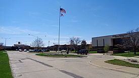
Southgate Municipal Complex
|
|||||
|
|||||
| Nickname(s):
"The Dining Capital of Downriver"
|
|||||
| Motto(s):
"The Heart of Downriver"
|
|||||

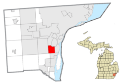
Location of Southgate in Wayne County, Michigan
|
|||||
| Country | United States | ||||
| State | Michigan | ||||
| County | Wayne | ||||
| Settled | 1795 | ||||
| Incorporated | October 8, 1958 | ||||
| Government | |||||
| • Type | Mayor–council | ||||
| Area | |||||
| • City | 6.875 sq mi (17.805 km2) | ||||
| • Land | 6.875 sq mi (17.805 km2) | ||||
| • Water | 0.000 sq mi (0.000 km2) | ||||
| Elevation | 591 ft (180 m) | ||||
| Population
(2020)
|
|||||
| • City | 30,014 | ||||
| • Estimate
(2023)
|
29,002 | ||||
| • Rank | MI: 38th | ||||
| • Density | 4,220/sq mi (1,629/km2) | ||||
| • Urban | 3,776,890 (US: 12nd) | ||||
| • Metro | 4,342,304 (US: 14th) | ||||
| Time zone | UTC−5 (Eastern (EST)) | ||||
| • Summer (DST) | UTC−4 (EDT) | ||||
| ZIP Code |
48195
|
||||
| Area code(s) | 734 | ||||
| FIPS code | 26-74960 | ||||
| GNIS feature ID | 0638446 | ||||
| Sales tax | 6.0% | ||||
Southgate is a city located in Wayne County, Michigan, United States. In 2020, about 30,047 people lived there. Southgate became an official city on October 8, 1958. It was one of the last parts of what used to be a larger area called Ecorse Township. Southgate is part of a group of communities known as Downriver, which are located south of the big city of Detroit.
Contents
History of Southgate
Early Settlers and Farming Life
The first European settler in the Southgate area was Pierre Michel Campau. He arrived in 1795. The area then grew into a farming community. Other people from the Detroit area, especially near the Rouge and Detroit Rivers, soon followed him to Southgate.
How Southgate Got Its Name
Southgate was once a rural part of Ecorse Township. Streets were first planned in the 1920s, but most building happened after World War II. The Old Homestead neighborhood is one of the oldest places to live in the city.
There are two main stories about how Southgate got its name. One idea is that it's the "South Gate" or entrance to the Metro Detroit area. This idea was shared in a newspaper story in 1956.
The city's first mayor, Thomas J. Anderson, gave another explanation in 1956. He said the name came from the new Southgate Shopping Center. This shopping center was being planned at the corner of Eureka and Trenton roads. Anderson explained that they wanted their own post office. They were told it would help if the township created a special "unincorporated village." The name Southgate was chosen because of the shopping center. Anderson had also thought of the name because of the city's location south of Detroit. He had learned about South Gate, California during World War II. The name was officially chosen in the summer of 1953.
First Mayor and City Growth
Thomas Anderson became Southgate's first mayor in 1958. Before that, he was the supervisor for Ecorse Township for five years. Southgate Anderson High School was named after him in 1982. The city's flag was created in 1973.
Geography of Southgate
Southgate covers a total area of about 6.875 square miles (17.805 square kilometers). All of this area is land.
Southgate shares its borders with several other cities. To the south, it borders Riverview. To the east, it borders Wyandotte. Allen Park is to the northwest, and Taylor is to the west. To the north, you'll find Lincoln Park. Finally, Brownstown Charter Township is to the southwest.
Population and People
| Historical population | |||
|---|---|---|---|
| Census | Pop. | %± | |
| 1960 | 29,404 | — | |
| 1970 | 33,909 | 15.3% | |
| 1980 | 32,058 | −5.5% | |
| 1990 | 30,771 | −4.0% | |
| 2000 | 30,136 | −2.1% | |
| 2010 | 30,047 | −0.3% | |
| 2020 | 30,014 | −0.1% | |
| 2023 (est.) | 29,002 | −3.5% | |
| U.S. Decennial Census 2020 Census |
|||
2020 Population Data
| Race | Number | Percentage |
|---|---|---|
| White (NH) | 22,544 | 75.1% |
| Black or African American (NH) | 2,283 | 7.6% |
| Native American or Alaska Native (NH) | 109 | 0.4% |
| Asian (NH) | 759 | 2.5% |
| Pacific Islander (NH) | 6 | 0.0% |
| Some Other Race (NH) | 122 | 0.6% |
| Mixed/Multi-Racial (NH) | 1,448 | 4.8% |
| Hispanic or Latino | 2,743 | 9.1% |
| Total | 30,014 | 100.0% |
In 2020, Southgate had 30,014 people living in the city. There were 13,497 households and 7,784 families. The city had about 4,366 people per square mile. Most residents were White (77.9%), with African Americans making up 7.8% and Asians 2.5%. About 9.1% of the population identified as Hispanic or Latino.
Almost 20% of the residents were under 18 years old. About 18.7% were 65 years or older.
2010 Population Data
In 2010, Southgate had 30,047 people. There were 13,062 households. About 27.4% of households had children under 18. The average household had 2.29 people.
The average age in the city was 40.8 years. About 20.3% of residents were under 18. About 16.3% were 65 or older. The population was slightly more female (52.3%) than male (47.9%).
Economy and Shopping
The Southgate Shopping Center first opened its doors in 1957. It has been a central place for shopping in the city for many years.
Parks and Recreation
Southgate is home to the Southgate Civic Center. It also has the Southgate Fun and Fitness Centre YMCA. These places offer activities and spaces for residents to stay active and have fun.
Education in Southgate
Public Schools
The Southgate Community School District runs several public schools for students of all ages:
- Anderson High School
- Davidson Middle School
- Allen Elementary
- Fordline Elementary
- Grogan Elementary
- North Pointe IB Elementary
- Shelters Elementary
Private Schools
There are also private schools in Southgate:
- Christ the King Lutheran
- St. Pius X (opened in September 1950)
- Creative Montessori Academy
Local News and Media
Southgate is where the main office of The News-Herald is located. This is a local newspaper that covers over twenty communities in the Downriver area. In the past, a newspaper called The Southgate Sentinel was published here. Southgate also gets news from larger regional newspapers like Detroit Free Press and The Detroit News. People in Southgate can also listen to Detroit's radio stations and watch its television channels.
Transportation in Southgate
Highways and Roads
 I-75 is a major highway that runs through the northwest part of the city, going south to north.
- Dix-Toledo Highway used to be called
 US 25 from 1929 to 1967.
  M-85, also known as Fort Street, runs north to south. It forms most of the eastern border of Southgate with Wyandotte.
Railways
The Conrail Shared Assets Lincoln Secondary is a railway line that goes through the northwest part of Southgate. It is mostly used by CSX Transportation freight trains that travel between Detroit and Toledo, Ohio. This railway is known for a very large grade crossing (where the train tracks cross a road at the same level) at the intersection of Northline and Allen Roads. There is also a crossing at Reeck Road.
Public Buses
Four bus routes operated by the Suburban Mobility Authority for Regional Transportation (SMART) pass through Southgate. These buses help people get around the city and to nearby areas.
Notable People from Southgate
- Ashley Qualls, a young internet business owner.
- Marcie Bolen, a musician from the rock and roll garage band Von Bondies.
See also
 In Spanish: Southgate (Míchigan) para niños
 | Misty Copeland |
 | Raven Wilkinson |
 | Debra Austin |
 | Aesha Ash |


