Woodhaven, Michigan facts for kids
Quick facts for kids
Woodhaven, Michigan
|
|
|---|---|

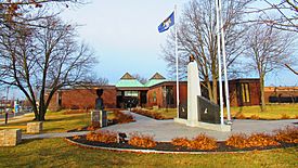
Woodhaven City Hall on Hall Road
|
|

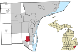
Location within Wayne County
|
|
| Country | |
| State | |
| County | |
| Incorporated | 1965 |
| Government | |
| • Type | Mayor–council |
| Area | |
| • City | 6.44 sq mi (16.69 km2) |
| • Land | 6.39 sq mi (16.55 km2) |
| • Water | 0.06 sq mi (0.15 km2) |
| Elevation | 604 ft (184 m) |
| Population
(2020)
|
|
| • City | 12,941 |
| • Density | 2,025.83/sq mi (782.12/km2) |
| • Metro | 4,285,832 (Metro Detroit) |
| Time zone | UTC-5 (EST) |
| • Summer (DST) | UTC-4 (EDT) |
| ZIP code(s) | |
| Area code(s) | 734 |
| FIPS code | 26-88380 |
| GNIS feature ID | 1616746 |
Woodhaven is a city located in Wayne County, Michigan, United States. It is part of a group of communities known as Downriver. In 1965, Woodhaven officially became a city. According to the 2020 United States census, about 12,941 people live there.
Contents
Where is Woodhaven Located?
Woodhaven is in Wayne County, Michigan. The city covers a total area of about 6.45 square miles (16.69 square kilometers). Most of this area is land, with a small part being water.
What are Woodhaven's ZIP Codes?
Woodhaven uses two main ZIP Codes. The 48183 ZIP Code covers most of the city. It is also shared with nearby Trenton and parts of Brownstown Township. A smaller section in the southwest of Woodhaven uses the 48134 ZIP Code. This code is shared with Flat Rock.
How Many People Live in Woodhaven?
| Historical population | |||
|---|---|---|---|
| Census | Pop. | %± | |
| 1970 | 3,566 | — | |
| 1980 | 10,902 | 205.7% | |
| 1990 | 11,631 | 6.7% | |
| 2000 | 12,530 | 7.7% | |
| 2010 | 12,875 | 2.8% | |
| 2020 | 12,941 | 0.5% | |
| U.S. Decennial Census | |||
Woodhaven's Population in 2010
In 2010, the city had 12,875 residents. There were 5,159 households, with 3,535 being families. The city had about 2,015 people per square mile.
- Most residents (88.9%) were White.
- About 5.3% were African American.
- Around 2.3% were Asian.
- About 5.5% of the population identified as Hispanic or Latino.
The average age in Woodhaven was 40.3 years. About 22.3% of the people were under 18 years old.
Education in Woodhaven
Most students in Woodhaven attend schools within the Woodhaven-Brownstown School District. A small part of the city's southern area is served by the Gibraltar School District.
Major Roads and Highways
Several important roads pass through or near Woodhaven:
 I-75: This major highway runs north and south right through the middle of Woodhaven.
 US 25: This was an older U.S. highway. It used to run along what is now Dix–Toledo Road. This road touches a small part of Woodhaven's northwest corner.
 M-85: This state highway touches the far southeastern edge of Woodhaven but does not go through the city itself.
Interesting Places in Woodhaven
Ford Stamping Plant
Woodhaven is well-known for being home to the Ford Stamping Plant. This large factory opened in 1964. It is located on the north side of West Road, close to I-75. The plant covers 360 acres and the building itself is huge, at 2,673,000 square feet. Many people work here, with about 470 employees.
Woodhaven Commons
The main shopping area in Woodhaven is called Woodhaven Commons. It started to develop in 1971 when a Kmart store opened. This area is centered around the intersection of Allen and West Roads. Over time, more stores and businesses joined the area.
Woodhaven Village Square
In the late 1990s, an old Mobil Oil Refinery and canning site was taken down. This area, on the west side of Allen Road, was then redeveloped. Between 2001 and 2005, it became the Woodhaven Village Square, offering new places for shopping and businesses.
See also
 In Spanish: Woodhaven (Míchigan) para niños
 | May Edward Chinn |
 | Rebecca Cole |
 | Alexa Canady |
 | Dorothy Lavinia Brown |


