
Wolverine, Michigan facts for kids
Quick facts for kids
Wolverine, Michigan
|
|
|---|---|
|
Village
|
|
| Village of Wolverine | |

Main Street and South Straits Highway
|
|
| Motto(s):
This is Sturgeon River Country
|
|
,_MI_location_2020.png)
Location within Cheboygan County
|
|

Wolverine, Michigan
Location in Michigan

Wolverine, Michigan
Location in the United States
|
|
| Country | United States |
| State | Michigan |
| County | Cheboygan |
| Townships | Nunda and Wilmot |
| Settled | 1874 |
| Incorporated | 1903 |
| Government | |
| • Type | Village council |
| Area | |
| • Total | 0.99 sq mi (2.56 km2) |
| • Land | 0.98 sq mi (2.54 km2) |
| • Water | 0.01 sq mi (0.02 km2) |
| Elevation | 817 ft (249 m) |
| Population
(2020)
|
|
| • Total | 309 |
| • Density | 314.34/sq mi (121.42/km2) |
| Time zone | UTC-5 (Eastern (EST)) |
| • Summer (DST) | UTC-4 (EDT) |
| ZIP code(s) |
49799
|
| Area code(s) | 231 |
| FIPS code | 26-88240 |
| GNIS feature ID | 1616712 |
Wolverine is a small village located in Cheboygan County, in the state of Michigan, USA. In 2020, about 309 people lived there.
The village is mostly in Nunda Township. A small part of it also stretches into Wilmot Township. Wolverine is found just west of Interstate 75. It is about 40 miles (64 km) south of the Mackinac Bridge.
Contents
History of Wolverine Village
Early Settlement and Naming
The area where Wolverine is now located was first settled around 1874. Jacob Shook and his family were among the first to live there. Later, George Richards moved to the area. He named the community "Torrey."
Getting to Torrey was hard back then. The closest train line ended in Gaylord, which was about 20 miles (32 km) south. George Richards often traveled to Gaylord for mail and supplies. He would usually stop halfway in Vanderbilt.
The First Post Office
Because of the long trip, Richards asked for a post office closer to his community. His request was approved in late 1880. The post office officially opened on January 3, 1881. It was named "Wolverine" and is still open today. George Richards became the first postmaster, which means he was in charge of the post office.
Richards was an important early settler. He helped set up the local school system. He also worked as a real estate dealer and a lumberman, someone who works with wood. In 1903, he was elected to the Michigan House of Representatives.
Growth and Decline
In 1881, only 18 people lived in Wolverine. Soon after, a company called the Jackson, Lansing, and Saginaw Railroad Company started building a train line nearby. By 1891, Wolverine's population grew to about 1,000 people. Most of them worked for the railroad or in the lumber industry.
Wolverine officially became a village in 1903. By 1905, the population reached around 1,800. However, the lumber industry started to slow down in the 1930s. Many people left Wolverine, and the population dropped a lot.
Geography and Location
Village Area
According to the U.S. Census Bureau, Wolverine covers a total area of about 0.99 square miles (2.56 square kilometers). Most of this area, about 0.98 square miles (2.54 square kilometers), is land. A very small part, about 0.01 square miles (0.02 square kilometers), is water.
The Sturgeon River
Wolverine is located on the Sturgeon River. This is where the west branch of the river joins the main branch. The river flows through the village.
Wolverine's ZIP Code
Wolverine has its own post office with the ZIP Code 49799. This is the highest number for a ZIP Code in Michigan's Lower Peninsula. The Wolverine post office serves a much larger area than just the village itself. It covers most of Nunda Township and Wilmot Township. It also serves smaller parts of other nearby townships. These include Ellis Township, Mentor Township, Corwith Township in Otsego County, Chandler Township in Charlevoix County, and Springvale Township in Emmet County.
Population and People
| Historical population | |||
|---|---|---|---|
| Census | Pop. | %± | |
| 1910 | 794 | — | |
| 1920 | 413 | −48.0% | |
| 1930 | 300 | −27.4% | |
| 1940 | 257 | −14.3% | |
| 1950 | 318 | 23.7% | |
| 1960 | 292 | −8.2% | |
| 1970 | 303 | 3.8% | |
| 1980 | 364 | 20.1% | |
| 1990 | 283 | −22.3% | |
| 2000 | 359 | 26.9% | |
| 2010 | 244 | −32.0% | |
| 2020 | 309 | 26.6% | |
| U.S. Decennial Census | |||
Population in 2010
In 2010, there were 244 people living in Wolverine. These people lived in 94 households, and 64 of these were families. The village had about 249 people per square mile (96 people per square kilometer). There were 146 homes in total.
Most of the people in Wolverine were White (94.3%). A small number were Asian (0.8%), and 4.9% were from two or more races. About 1.2% of the population identified as Hispanic or Latino.
Households and Families
Out of the 94 households, about 37% had children under 18 living with them. More than half (51.1%) were married couples living together. About 12.8% of households had a female head with no husband present. A small number (4.3%) had a male head with no wife present. About 31.9% of households were not families.
About 25.5% of all households had only one person living there. About 14.9% had someone aged 65 or older living alone. On average, there were 2.60 people per household and 3.14 people per family.
Age Groups
The average age of people in Wolverine was 40.3 years old. About 27% of the residents were under 18 years old. About 4.9% were between 18 and 24 years old. People aged 25 to 44 made up 23.7% of the population. Those aged 45 to 64 were 28.7%. Finally, 15.6% of the residents were 65 years old or older. The village had slightly more females (53.7%) than males (46.3%).
Images for kids
-
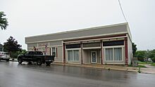
Village office and library -
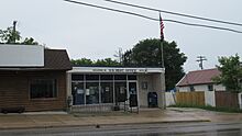
U.S. Post Office in Wolverine -
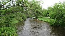
Sturgeon River flowing through Wolverine -
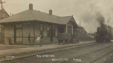
Michigan Central Depot in 1920 -
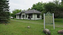
Michigan Central Depot in 2021


.jpg)
_1920.png)
.jpg)
See also
 In Spanish: Wolverine (Míchigan) para niños
