South Higgins Lake State Park facts for kids
Quick facts for kids South Higgins Lake State Park |
|
|---|---|
|
IUCN Category III (Natural Monument)
|
|

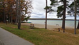
Beachfront area along Higgins Lake
|
|
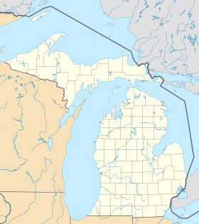
| Location | Gerrish and Markey townships, Roscommon County, Michigan |
| Nearest city | Grayling, Michigan |
| Area | 1,000 acres (400 ha) |
| Elevation | 1,152 feet (351 m) |
| Designation | Michigan state park |
| Established | 1927 |
| Administrator | Michigan Department of Natural Resources |
| Website | South Higgins Lake State Park |
South Higgins Lake State Park is a cool outdoor spot in Michigan. It covers about 1,000 acres (400 ha) (that's like 750 football fields!) on the southern side of Higgins Lake. This park is a great place for families and friends to enjoy nature. It's located in Roscommon County, not too far from the town of Roscommon. The park also completely surrounds a smaller lake called Marl Lake and parts of the Cut River.
Contents
Exploring South Higgins Lake State Park
This park is split into two main parts by a road called County Road 100.
North Section: Fun by the Lake
The northern part of the park is about 300-acre (120 ha). This is where you'll find most of the park's main areas. It's located right between Higgins Lake and County Road 100. This section is perfect for swimming, boating, and enjoying the beach.
Marl Lake Section: Trails and Nature
The southern part of the park is much bigger, covering about 700-acre (280 ha). This area is less developed, which means it's more wild and natural. It has about 5.5 miles (8.9 km) of trails that are great for hiking. The park has a mix of different trees, like pine, oak, and maple.
Wildlife You Might See
South Higgins Lake State Park is home to many cool animals. If you're lucky, you might spot:
- Bald eagles, which build their nests here
- Migratory loons, a type of water bird
- Kingfishers
- Wild turkeys
Park History: How it Grew
South Higgins Lake State Park first opened its doors in 1927. When it started, it was much smaller, only about 100 acres (40 ha). It had a campground with just 15 spots for tents or RVs.
Over the years, the park became very popular. Its campground grew a lot and now has 400 spots! This makes it the second-largest camping area in the entire Michigan state park system.
A big change happened in 1984. The state bought the 700 acres (280 ha) section around Marl Lake. This made the park much larger and protected the natural area from being developed by private companies.
Things to Do at the Park
South Higgins Lake State Park offers tons of fun activities for everyone:
- Swimming: Enjoy the clear waters of Higgins Lake.
- Boating: Bring your boat or rent one to explore the lake.
- Fishing: Try to catch some fish in Higgins Lake or Marl Lake.
- Hiking: Walk or run on the 5.5 miles (8.9 km) of trails.
- Cross-country skiing: In winter, the trails are great for skiing.
- Hunting: Some areas allow hunting during specific seasons.
- Picnicking: Have a nice outdoor meal with your family and friends.
- Camping: Stay overnight at the large 400-site campground.
 | Selma Burke |
 | Pauline Powell Burns |
 | Frederick J. Brown |
 | Robert Blackburn |


