
Ecorse River facts for kids
Quick facts for kids Ecorse River |
|
|---|---|

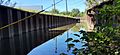
The north branch at Council Point Park
|
|

Location within the state of Michigan
|
|
| Other name(s) | Rivière aux Écorces |
| Physical characteristics | |
| River mouth | Detroit River 42°14′06″N 83°08′50″W / 42.23500°N 83.14722°W |
| Length | 18.8 miles (30.3 km) |
The Ecorse River is a river in southern Michigan that is about 18.8-mile-long (30.3 km). Because it's not very big, people often call it Ecorse Creek. It flows through the Downriver area of Metro Detroit and eventually joins the Detroit River.
Early French settlers named it Rivière aux Écorces, which means "bark river." They gave it this name because they saw local Native American tribes wrapping their deceased in birch or elm bark before burying them near the river's mouth. The Ecorse River has two main branches. These branches meet at Council Point Park in Lincoln Park. This park is famous because Chief Pontiac held an important meeting there in 1763 before attacking Fort Detroit.
Contents
About the Ecorse River
The Ecorse River system has two main parts: a South Branch and a North Branch. The South Branch is about 4.5-mile-long (7.2 km), but if you include the Sexton-Kilfoil Drain, it's about 10.7-mile-long (17.2 km). The North Branch is longer, at about 18.2-mile-long (29.3 km). After these two branches meet, they flow together for another 0.6-mile-long (0.97 km) before reaching the Detroit River.
The land around the river, called its watershed, covers about 43.4 square miles (112 km2). The highest point in the watershed is 670 feet (200 m) above sea level, and it drops to 575 feet (175 m) at the Detroit River. On average, the river flows at about 3.2 cubic feet (0.091 m3) of water per second each year.
River Branches and Drains
The North Branch of the river drains an area of about 18.75 square miles (48.6 km2). It has smaller streams, called tributaries, that flow into it. These include the Trouton Drain, Freeman Drain, Black Creek, and the Douglas and Kelly Drain.
The South Branch drains about 12 square miles (31 km2). Its tributaries include the Grams Drain in Southgate and the Brighton, Bondie, and the Sloss and Ganong Drains in Taylor. The Sexton and Kilfoil Drain also joins the South Branch in Taylor.
There are also underground drains that feed into the river. The largest of these is the La Blanc Drain, which drains about 12 square miles (31 km2) of land. It joins the North Branch close to where the North and South branches meet.
Where the River Flows
The North Branch flows through several cities: Romulus, Dearborn Heights, Allen Park, a small part of Melvindale, and Lincoln Park. It also forms part of the border between Lincoln Park and Ecorse.
The South Branch flows through Romulus, Taylor, Allen Park, and Lincoln Park. After the two branches join in Lincoln Park, the river continues along the border between Ecorse and Wyandotte until it reaches the Detroit River. Near where the river meets the Detroit River, there's a marina with boats on both sides.
River Challenges
The Ecorse River flows downhill very slowly, which means it collects a lot of mud and dirt. This "silting" makes seasonal flooding worse. The soil in the watershed is mostly clay, which doesn't soak up much water. Also, about 85% of the land in the area is covered by homes, businesses, or factories. This means less open ground to absorb rainwater.
Because of these issues, homes near the river often need flood insurance, and damaging floods happen regularly. For example, on May 21, 2004, 4 inches (100 mm) of rain caused the river to rise over 6 feet (1.8 m) in just three hours!
The Ecorse River flows into the Detroit River roughly in the middle of its path. To the north of the Ecorse River is the Rouge River, and to the south is the Huron River.
The area around the river is very developed, with many people living there. In 2000, there were about 3,711 people per square mile. There are also many factories and businesses. Because of this, the river has faced problems with pollution from industries and homes, as well as from old steel factories along its lower parts.
Controlling Floods
In September 2008, officials announced a big project to help protect the nine towns along the North Branch from sudden floods. This project was planned to cost $239 million. The first part of the project, which started in early 2009, cost between $7 million and $10 million. It was paid for by special fees on the 48,000 properties in the river's watershed. This first phase involved changing 80 places where paths cross the creek and building new drains and basins to help manage water.
Important Notes
Some people call the North and South branches "Ecorse Creek" and only refer to the short section where they combine as the "Ecorse River."
In April 2009, a high amount of E. coli bacteria, which comes from human waste, was found in the creek water. Officials warned people to stay away from the water for safety.
Images for kids
-
The Sexton and Kilfoil Drain in Taylor, Michigan

