
Romulus, Michigan facts for kids
Quick facts for kids
Romulus, Michigan
|
||
|---|---|---|
| City of Romulus | ||
|
Top: Downtown Romulus, looking west from Goddard Road and Hunt Street; bottom: Detroit Metropolitan Wayne County Airport.
|
||
|
||
| Nickname(s):
"Rom-town"
|
||
| Motto(s):
"Home of Opportunity"
|
||

Location within Wayne County
|
||

Romulus, Michigan
Location in Michigan

Romulus, Michigan
Location in the United States
|
||
| Country | ||
| State | ||
| County | Wayne | |
| Settled | 1826 | |
| Organized | 1835 (Romulus Township) | |
| Incorporated | 1970 | |
| Government | ||
| • Type | Mayor–council | |
| Area | ||
| • City | 35.95 sq mi (93.12 km2) | |
| • Land | 35.61 sq mi (92.22 km2) | |
| • Water | 0.34 sq mi (0.89 km2) | |
| Elevation | 659 ft (201 m) | |
| Population
(2020)
|
||
| • City | 25,178 | |
| • Density | 707.09/sq mi (273.01/km2) | |
| • Metro | 4,285,832 (Metro Detroit) | |
| Time zone | UTC-5 (Eastern (EST)) | |
| • Summer (DST) | UTC-4 (EDT) | |
| ZIP code(s) |
48174, 48184
48242 (Detroit) |
|
| Area code(s) | 734 | |
| FIPS code | 26-69420 | |
| GNIS feature ID | 0636147 | |


Romulus is a city in Wayne County, Michigan, in the United States. In 2020, about 25,178 people lived there. Romulus is a western suburb of Metro Detroit. It is also part of the Downriver area, a group of communities along the Detroit River. The city is best known as the home of the Detroit Metropolitan Airport. This airport is a major hub for Delta Air Lines.
Contents
History of Romulus
The first European settler in Romulus was Samuel Polyne in 1826. He was French-Canadian. He settled on a piece of land but left soon after.
Samuel McMath moved to the area from New York in 1827. He worked on the land and planned to bring his family. Sadly, he died before they could join him.
Other early settlers arrived in the 1830s. In 1833, Jenks Pullen and his six sons settled at a spot called "Pullen's Corners." This area is now known as "Five Points."
How Romulus Became a City
Romulus Township was officially created on March 17, 1835. It was separated from Huron Township. The first meeting for the township was held on April 16, 1835. This was two years before Michigan became a state.
The township's name was briefly changed to "Wayne" in 1845. However, it was changed back to Romulus in 1848. Romulus officially became a city in 1970.
Underground Railroad Stops
Romulus was an important stop on the Underground Railroad in the 1800s. The Underground Railroad was a secret network of safe houses. It helped enslaved people escape from the Southern states to freedom in the North.
There were two known stops in Romulus. These buildings are still standing today.
- Samuel Kingsley Home: Samuel R. Kingsley lived in a house on Ozga Road. He helped hide enslaved people in a secret underground cellar. Today, this historic house is on Hunt Street. It is across from the Romulus Historical Museum.
- The White Church: This church was also a stop on the Underground Railroad. It is located at Pullen's Corner, also known as Five Points. Today, it is called 5 Points Church.
Major Events in Romulus
On August 16, 1987, a plane crash happened near Detroit Metro Airport in Romulus. The plane crashed shortly after taking off. A memorial for those who died is located at the crash site.
On August 9, 2005, a chemical plant in Romulus caught fire. Smoke filled the sky, and people living nearby had to leave their homes. Fire crews from Romulus and other towns worked to put out the fire. No one was seriously hurt.
Geography of Romulus
Romulus covers about 35.95 square miles (93.12 square kilometers). Most of this area is land. A small part is water.
The city is in the south-central part of Wayne County. Two major highways, Interstate 94 (I-94) and I-275, run through Romulus.
Romulus has clear borders. Van Born Road is to the north. Pennsylvania Road is to the south. Inkster Road is to the east. Hannan Road is to the west.
Population of Romulus
| Historical population | |||
|---|---|---|---|
| Census | Pop. | %± | |
| 1970 | 22,900 | — | |
| 1980 | 24,857 | 8.5% | |
| 1990 | 22,897 | −7.9% | |
| 2000 | 22,979 | 0.4% | |
| 2010 | 23,989 | 4.4% | |
| 2020 | 25,178 | 5.0% | |
| U.S. Decennial Census 2018 Estimate |
|||
Who Lives in Romulus?
In 2010, there were 23,989 people living in Romulus. There were 8,975 households. About 6,135 of these were families.
The population density was about 673.7 people per square mile. This means many people live close together.
The people living in Romulus come from different backgrounds. In 2010:
- 50.5% were White
- 43% were African American
- 0.5% were Native American
- 1.1% were Asian
- 0.1% were Pacific Islander
- 0.9% were from other races
- 3.9% were from two or more races.
About 3.0% of the population was Hispanic or Latino.
The average age in Romulus was 36.2 years old. About 26.8% of residents were under 18. About 9.8% were 65 or older. The population was almost evenly split between males (48.4%) and females (51.6%).
Parks and Recreation
Romulus has several parks where you can play and relax. For a short time in 2011, some parks closed due to money issues. But thanks to city officials and citizens, most parks have reopened. Some have even been improved. A new park has also opened.
Some of the parks in Romulus include:
- Elmer Johnson Park
- Eugenio Fernandez Park
- Mary Ann Banks Park
- Oakbrook Neighborhood Park
- Downtown Historical Park
- St. Johns Lodge No.#44 Park
The Romulus Athletic Center is a large building for sports and events. It opened in 2008. You can find it on Northline Road.
Education in Romulus


The Romulus Community School District teaches children in Romulus. The district has:
- A high school (Romulus Senior High School)
- A middle school
- An early childhood center
- Four elementary schools: Barth, Halecreek, Romulus, and Wick.
Some parts of Romulus are in the Wayne-Westland Community Schools district. Students there go to schools in Wayne, Michigan.
There are also charter schools in the area. These include Summit Academy Schools and Metro Charter Academy.
Notable People from Romulus
Many talented people have come from Romulus, Michigan. Some of them became professional athletes.
- Charley Lau – a professional baseball player and hitting coach.
- John Long – a professional basketball player.
- Grant Long – a professional basketball player.
- Terry Mills – a professional basketball player.
- Fred Russell – a professional football player.
- Frank Sacka – a professional baseball player for the Washington Senators.
Images for kids
-
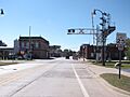
Downtown Romulus
-

Detroit Metropolitan Wayne County Airport
-
Seal of Romulus
-
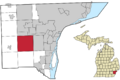
Location of Romulus in Wayne County
See also
 In Spanish: Romulus (Míchigan) para niños
